On the afternoon of March 28, Myanmar experienced a strong earthquake measuring 7.3 on the Richter scale with an epicenter 10 km deep, causing seismic energy to spread across the border and shake many areas in Vietnam. In Ho Chi Minh City and Hanoi, people witnessed unusual movements of the ground, accompanied by chaotic scenes as furniture and equipment in offices and apartments were moved, raising concerns about serious consequences.
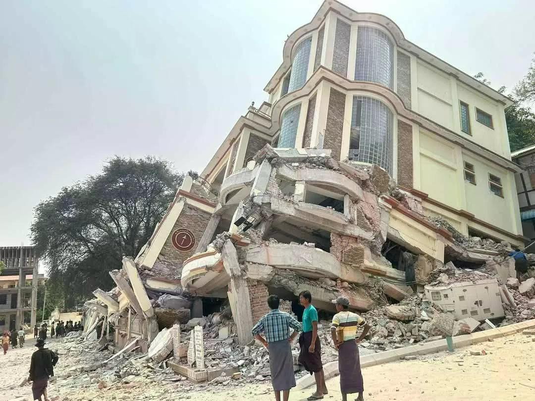
According to witnesses, at around 1:30 p.m., employees working in high-rise buildings in the center of Ho Chi Minh City felt the tremors clearly and were afraid to leave their workplaces. At the same time, in Hanoi, residents in districts such as Cau Giay and Hoang Mai also recorded strong shaking of household items from chandeliers to wall-mounted devices. Some residents in apartment buildings, especially those on the upper floors, quickly moved to the ground floor due to safety concerns.
Experts assessed that although some areas of Vietnam felt the tremors, the impact on infrastructure and people was not too serious, but it still affected the psychology of some people.
What are the main vibration points in the heart of Indochina?
According to the Institute of Geophysics – Vietnam Academy of Science and Technology, earthquakes are natural phenomena caused by the movement of tectonic plates in the Earth’s crust, or may be related to volcanic activity. When they occur, accumulated energy is released in the form of seismic waves, transmitted to the surface and causing shaking. The level of impact of an earthquake depends on its intensity and depth, ranging from mild shaking to severe damage to infrastructure and human life.
Although Vietnam is not located in an area with strong seismic activity like Japan or Indonesia, history has shown that many earthquakes of moderate to very strong intensity have occurred in many areas of the S-shaped strip of land.
Throughout its history from 114 to 2003, Vietnam has recorded 1,645 earthquakes with a magnitude of 3 or higher on the Richter scale. Notably, earthquakes of magnitude 7 and 8 occurred in many areas such as Bac Dong Hoi, Hanoi, Yen Dinh - Vinh Loc - Nho Quan and Nghe An. Some events even date back hundreds of years, such as the magnitude 8 earthquakes in Hanoi that occurred in 1277, 1278 and 1285, followed by strong earthquakes in other areas such as Phan Thiet in the late 19th century. These events not only demonstrate the power of nature but also serve as a warning about the possibility of future seismic phenomena.
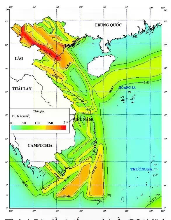
According to the Vietnam and East Sea Earthquake Hazard Probability Map published by the group of authors Nguyen Hong Phuong and Pham The Truyen, there are 37 areas with the highest risk of earthquakes in Vietnam.
Studies show that the strongest earthquake intensity is concentrated in the Northwest region, where there are Dien Bien - Lai Chau and Song Ma fault zones, as well as on the South Central continental shelf, especially the source area of Meridian 109. In the Dien Bien - Lai Chau and Son La source areas, the maximum ground acceleration value reaches a level equivalent to the surface earthquake intensity level IX on the MSK-64 scale, for a return period of about 10,000 years. In addition, some other source areas such as the Red River - Chay River, Rao Nay, Ca River - Khe Bo and Tra Bong are also identified to have strong ground vibrations corresponding to level VIII.
On the South Central continental shelf, the source area of Meridian 109 recorded the highest maximum ground acceleration value, while there were two other strong source areas, Cuu Long - Con Son and Thuan Hai - Minh Hai, reaching levels equivalent to level VIII on the MSK-64 scale. Meanwhile, the North East Sea and Hoang Sa - Truong Sa archipelago recorded low ground acceleration levels, only equivalent to surface earthquake intensity up to level VI.
Although Hanoi and Ho Chi Minh City are currently experiencing a relatively seismically quiet period, experts warn that the capital Hanoi, which sits on the Red River-Chay River fault zone, is at risk of earthquakes in the future. Studies estimate that the recurrence cycle of earthquakes of magnitude 5.4 on the Richter scale is about 1,100 years, while the last strong earthquake in Hanoi was recorded more than 700 years ago, in 1285. In addition, the capital is also at risk of being affected by strong earthquakes occurring in neighboring fault zones such as the Lo River, Dong Trieu and Son La.
The largest earthquakes in history ever recorded in Vietnam
Other areas of Vietnam such as the Northwest, North Central and Central Coast are also frequently affected by earthquakes. According to historical data, the 1935 earthquake in Dien Bien - recorded on the Ma River fault zone - with a magnitude of about 6.9 on the Richter scale, created severe tremors that spread to many neighboring areas. This event is considered one of the first earthquakes clearly recorded in our country.
In 1983, the Tuan Giao area of Dien Bien province continued to suffer a strong earthquake with a magnitude of up to 6.7 on the Richter scale. This is considered one of the strongest earthquakes of the 20th century in Vietnam, causing significant damage to houses and infrastructure in the Northwest region, while creating tremors felt in more remote areas, raising concerns about geological instability.
Entering the 21st century, seismic activity in the Central region has shown signs of a clear increase. Since 2012, the area around the Song Tranh 2 hydropower reservoir in Quang Nam province has continuously recorded stimulating earthquakes. Notably, the earthquake that occurred at 14:24 on November 15, 2012, with a magnitude of 4.7 on the Richter scale, caused cracks in houses, aroused panic in the community and led to many controversies about the safety of the Song Tranh 2 hydropower project.
Next, from 2021 to 2022, the Kon Plong area, Kon Tum province, also continuously recorded induced earthquakes due to the influence of the reservoir. The strongest earthquake here was about 4.5 on the Richter scale. Although it did not cause serious damage, the series of consecutive earthquakes has made people in the Central Highlands region worry about the risk of induced earthquakes in the future.
Although they do not occur frequently, earthquakes in Vietnam still have significant impacts, especially on infrastructure. Large earthquakes can crack walls, collapse houses and cause serious damage to buildings. In addition, the psychological impact of these events is not small, causing the community to face feelings of confusion and anxiety and promoting the urgent need to find effective response measures.
Source: https://baolaocai.vn/dong-dat-myanmar-canh-bao-nhung-vung-dut-gay-viet-nam-post399482.html


![[Photo] Closing of the 11th Conference of the 13th Central Committee of the Communist Party of Vietnam](https://vstatic.vietnam.vn/vietnam/resource/IMAGE/2025/4/12/114b57fe6e9b4814a5ddfacf6dfe5b7f)
![[Photo] Overcoming all difficulties, speeding up construction progress of Hoa Binh Hydropower Plant Expansion Project](https://vstatic.vietnam.vn/vietnam/resource/IMAGE/2025/4/12/bff04b551e98484c84d74c8faa3526e0)



























Comment (0)