
Ho Chi Minh City Nearly 200 meters of Thanh Da canal bank, Binh Thanh district, continues to sink nearly 2 cm per day after the embankment top collapsed, directly affecting 13 households living above.
The information has just been released by the Ho Chi Minh City Department of Transport after 9 days of monitoring and measurement by the Port Design and Marine Engineering Joint Stock Company (consultant). The results show that the nearly 200 m long Thanh Da canal bank is sinking vertically at an average of 1.78 cm per day and horizontally, sliding towards the canal bed about 2 cm. This situation is forecast to continue, with the risk of landslides affecting the constructions and houses built above.
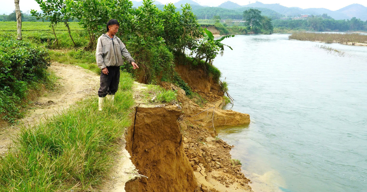
Nearly a month ago, this section of the canal bank collapsed, damaging about 120 meters of embankment. Many houses above it collapsed and cracked, and some leaned toward the canal. The city then had to urgently evacuate 13 households, and warned that the area at risk of landslides should be restricted to ensure safety.
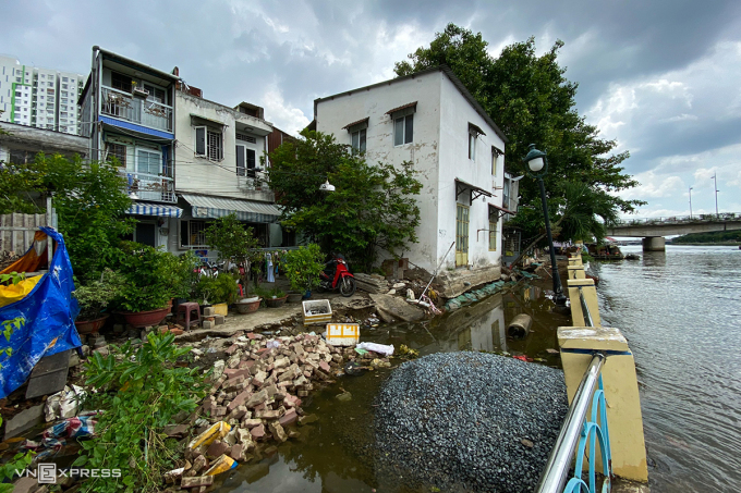
The embankment collapsed in Thanh Da nearly a month ago. Photo: Thanh Tung
To accurately assess the cause and solution, the consulting unit proposed a general survey and collection of additional data on topography, geology, hydrology, etc. However, the immediate measure is to lower the load of some houses near the top of the embankment to reduce the impact on the canal bank, temporarily ensuring the safety of the people. This was agreed upon by a number of related units.
According to Deputy Director of the Ho Chi Minh City Department of Transport Bui Hoa An, the Thanh Da embankment was completed in 2009. At that time, the residential buildings above had not been built and the safety corridor was 10 meters. Up to now, houses have been built about 3.5 meters from the top of the embankment, leading to a large load above.
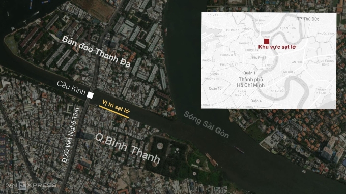
Landslide location on Thanh Da canal bank, Binh Thanh district on June 28. Graphics: Khanh Hoang
The Department has assigned the Waterway Management Center to provide documents related to the construction of the above embankment section to the consulting unit for research, assessment of specific causes and proposed solutions. Relevant units will also coordinate with local authorities to closely monitor and ensure safety for the people.
In addition, this agency requested Binh Thanh district to compile legal documents of houses, land, assets... of affected households to prepare for site clearance for embankment reinforcement after finding a solution.
In addition to the above area, on Thanh Da peninsula, construction projects to build embankments to prevent landslides in many other sections are also being implemented. Of which, the two construction packages of section 2 (Saigon River - Saigon Domaine Hotel) and section 4 (Saigon River - Ly Hoang Villa to La San Mai Thon Church) are behind schedule, so the investor plans to terminate the contract and choose a new contractor to speed up the progress.
Gia Minh
Source link

![[Photo] General Secretary To Lam receives French Ambassador to Vietnam Olivier Brochet](https://vstatic.vietnam.vn/vietnam/resource/IMAGE/2025/4/17/49224f0f12e84b66a73b17eb251f7278)
![[Photo] Promoting friendship, solidarity and cooperation between the armies and people of the two countries](https://vstatic.vietnam.vn/vietnam/resource/IMAGE/2025/4/17/0c4d087864f14092aed77252590b6bae)
![[Photo] Nhan Dan Newspaper announces the project "Love Vietnam so much"](https://vstatic.vietnam.vn/vietnam/resource/IMAGE/2025/4/17/362f882012d3432783fc92fab1b3e980)
![[Photo] Closing of the 4th Summit of the Partnership for Green Growth and the Global Goals](https://vstatic.vietnam.vn/vietnam/resource/IMAGE/2025/4/17/c0a0df9852c84e58be0a8b939189c85a)
![[Photo] National Assembly Chairman Tran Thanh Man meets with outstanding workers in the oil and gas industry](https://vstatic.vietnam.vn/vietnam/resource/IMAGE/2025/4/17/1d0de4026b75434ab34279624db7ee4a)


![[Photo] Welcoming ceremony for Chinese Defense Minister and delegation for friendship exchange](https://vstatic.vietnam.vn/vietnam/resource/IMAGE/2025/4/17/fadd533046594e5cacbb28de4c4d5655)


![[Video] Viettel officially puts into operation the largest submarine optical cable line in Vietnam](https://vstatic.vietnam.vn/vietnam/resource/IMAGE/2025/4/17/f19008c6010c4a538cc422cb791ca0a1)


Comment (0)