
According to the National Center for Hydro-Meteorological Forecasting, as of 7:00 a.m. this morning (September 5), the center of storm No. 3 Yagi was located in the northern sea area of the North East Sea, about 520 km east of Hainan Island (China). The strongest wind near the center of the storm was level 15 (167-183 km/h), gusting over level 17. In the past hours, the storm has been moving slowly westward at a speed of about 10 km/h.
Thus, in the past 2 days, storm No. 3 has increased in intensity by 7 levels since entering the East Sea. Experts say that the intensity may increase to a super storm level 16, gusting over level 17 today in the northern waters of the North East Sea, faster than previous assessments. This can be considered the time when the storm reaches its maximum intensity.
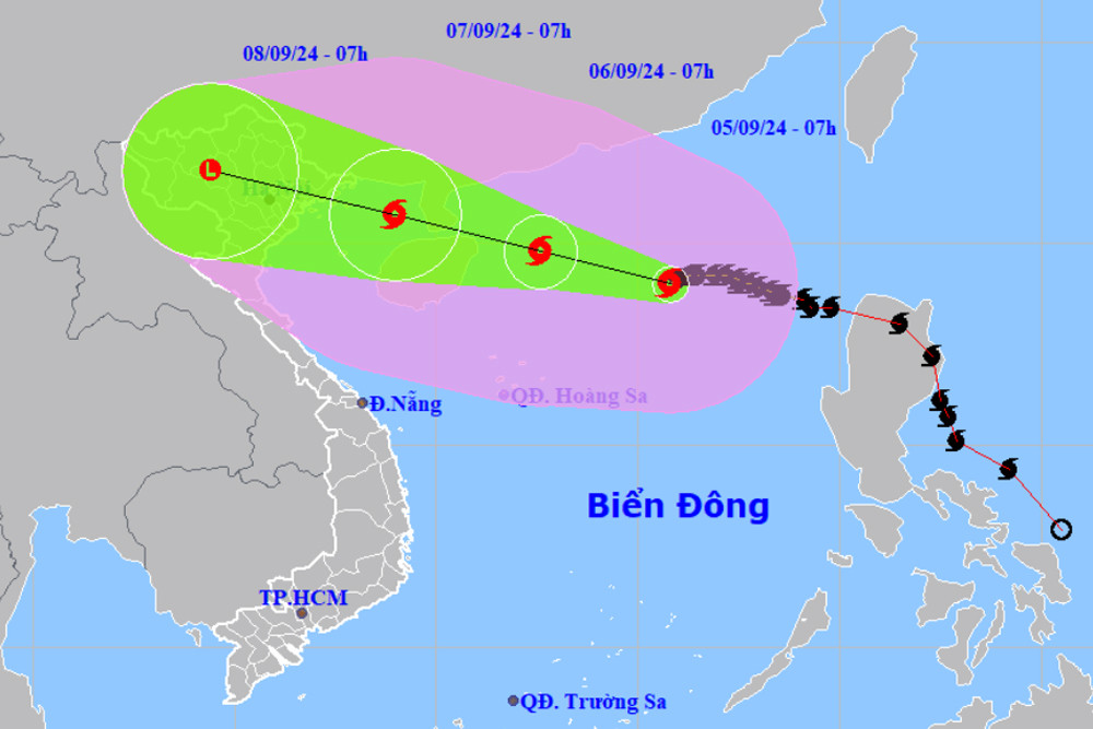
Forecast by 7am tomorrow morning (September 6), the eye of the storm is about 190km east of Hainan Island (China), about 590km east southeast of Quang Ninh. The strongest wind near the eye of the storm remains at level 16, gusting over level 17; moving west-northwest at a speed of 10-15km/h.
After passing Hainan Island, due to friction with the terrain, the storm will weaken and will no longer be a super typhoon. However, when entering the Gulf of Tonkin, the storm will still maintain a very strong intensity of level 13-14, gusting to level 17, due to warm sea conditions.
It is forecasted that around tomorrow night, the storm will enter the Gulf of Tonkin and begin to impact the mainland of the northeastern and north central provinces.
At 7:00 a.m. on September 7, the storm's center was in the northern Gulf of Tonkin, about 190 km east-southeast of Quang Ninh; it maintained its moving direction at 15-20 km/h and gradually weakened.
According to Mr. Hoang Phuc Lam, Deputy Director of the National Center for Hydro-Meteorological Forecasting, the most likely scenario at present is that the eye of the storm will make landfall in the Quang Ninh - Hai Phong area. However, due to the thousands of kilometers wide area of thunderstorms, the directly affected area (wind level 6 or higher with heavy rain) covers the entire North and North Central regions, focusing on Quang Ninh, Hai Phong, Thai Binh, Nam Dinh and Ninh Binh.
Mr. Lam also noted that when entering the mainland of our country, Typhoon Yagi will accelerate, so it will move quickly and end quickly. Specifically, on September 6, in the Gulf of Tonkin (Bach Long Vi and Co To island districts), the wind will gradually increase to level 6-7, gusting to level 9, and then quickly increase to level 10-13 when the storm enters the Gulf of Tonkin.
From the morning and noon of September 7, the mainland will begin to be affected by storm winds; the most dangerous time for strong winds is from the afternoon and night of September 7 to the morning of September 8.
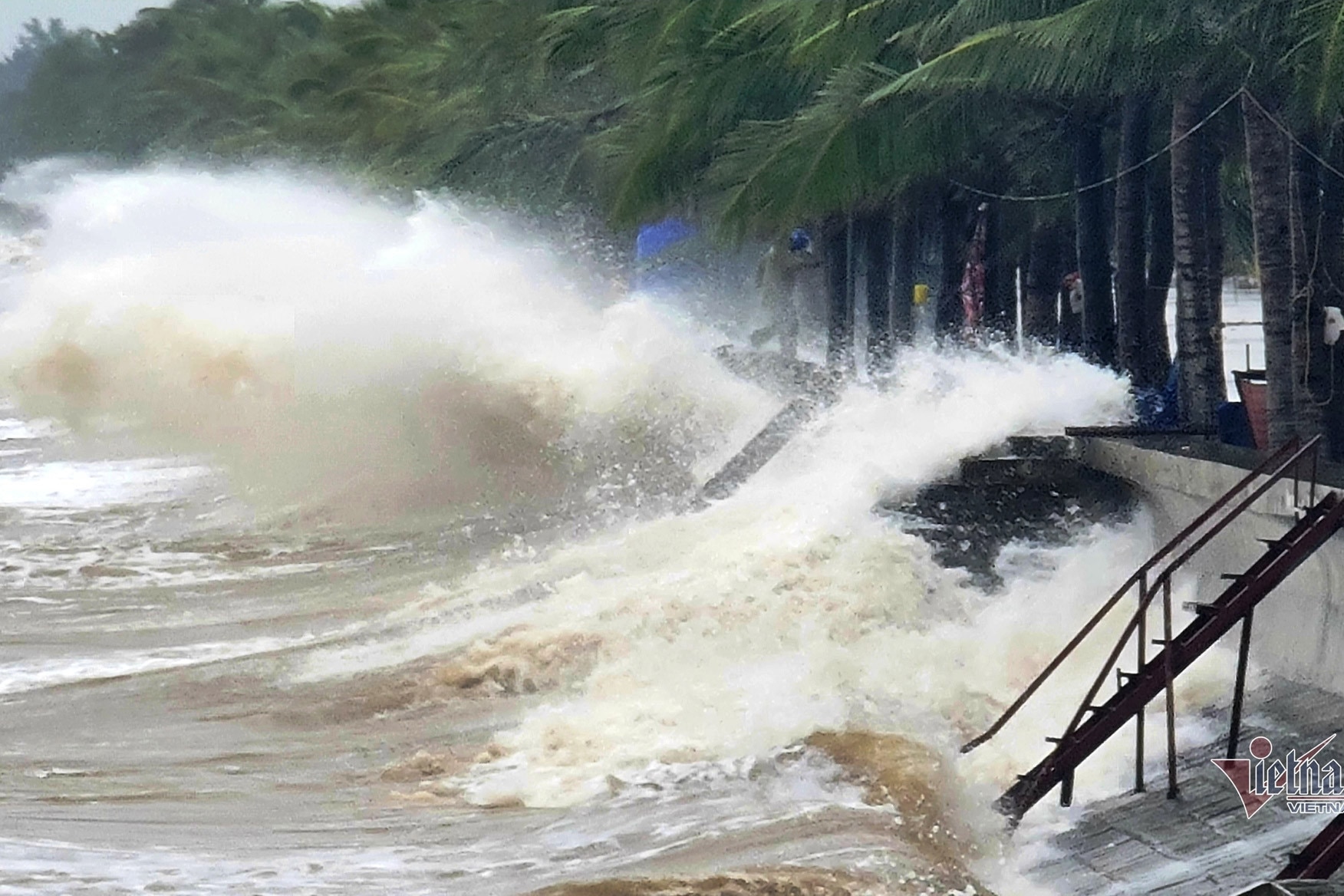
Storm No. 3 Yagi will cause widespread heavy rain in the Northern and North Central provinces; heavy to very heavy rain will cause widespread flooding in the plains and coastal areas of the provinces from Thanh Hoa to Ha Tinh. Heavy rain, concentrated in a short period of time, is a special danger of flash floods and landslides, concentrated in the mountainous and midland areas of the Northern and North Central regions.
Specifically, from the night of September 6 to the morning of September 9, in the Northern and North Central regions, there is a possibility of heavy rain, locally very heavy rain and thunderstorms with total rainfall ranging from 100-300mm, in some places over 500mm.
Waves up to 12m high Due to the influence of storm No. 3, the North East Sea has strong winds of level 11-13, near the eye of the storm level 14-16, gusting to level 17; waves 7-9m high, near the eye of the storm 10-12m. The sea is very rough. From the night of September 6, the Gulf of Tonkin (including Bach Long Vy and Co To island districts) has strong winds of level 10-12, near the eye of the storm level 13-14, gusting to level 17; the sea is very rough; waves 2-4m high, later increasing to 3-5m, near the eye of the storm 6-8m. From early morning on September 7, coastal areas from Quang Ninh to Thanh Hoa provinces will have winds gradually increasing to level 6-7, then increasing to level 8-9, near the storm center level 10-12, gusting to level 14; inland areas in the Northeast region, winds will be strong at level 6-8, gusting to level 9-11. Provinces need to be on guard against storm surges: Quang Ninh from 1.5-1.8m; Hai Phong and Thai Binh from 1.2-1.5m; Nam Dinh and Ninh Binh from 0.8-1.2m; Thanh Hoa: 0.5-1.0m. Boat mooring areas, aquaculture areas, dykes and seawalls in the above-mentioned dangerous areas are all likely to be affected by strong winds, large waves and storm surges. |

Storm No. 3 Yagi likely to enter the Gulf of Tonkin 70-80%, heavy rain in the North
The possibility of storm No. 3 making landfall in the Gulf of Tonkin is 70-80%, with storm intensity reaching level 15 or 16. From around the night of September 6, although far away, the storm's edge will still cause heavy rain in the North.

Hanoi weather for the next 3 days: Heavy rain, strong wind right after hot weather
Weather forecast for Hanoi in the next 3 days (September 5-7) is that it will be hot and sunny with temperatures reaching 36 degrees Celsius. Then, due to the influence of storm No. 3 Yagi, from the night of September 6, the area will start to have heavy rain and strong winds.
2 scenarios of storm number 3 making landfall, heavy rain across the North and North Central regions
According to experts, storm No. 3 is likely to reach a maximum level of 14, gusting to level 17 in the northern East Sea. When the storm makes landfall, its circulation will be wide, along the northern and north central provinces.
![[Photo] Closing of the 4th Summit of the Partnership for Green Growth and the Global Goals](https://vstatic.vietnam.vn/vietnam/resource/IMAGE/2025/4/17/c0a0df9852c84e58be0a8b939189c85a)

![[Photo] Nhan Dan Newspaper announces the project "Love Vietnam so much"](https://vstatic.vietnam.vn/vietnam/resource/IMAGE/2025/4/17/362f882012d3432783fc92fab1b3e980)
![[Photo] General Secretary To Lam receives French Ambassador to Vietnam Olivier Brochet](https://vstatic.vietnam.vn/vietnam/resource/IMAGE/2025/4/17/49224f0f12e84b66a73b17eb251f7278)
![[Photo] Promoting friendship, solidarity and cooperation between the armies and people of the two countries](https://vstatic.vietnam.vn/vietnam/resource/IMAGE/2025/4/17/0c4d087864f14092aed77252590b6bae)
![[Photo] National Assembly Chairman Tran Thanh Man meets with outstanding workers in the oil and gas industry](https://vstatic.vietnam.vn/vietnam/resource/IMAGE/2025/4/17/1d0de4026b75434ab34279624db7ee4a)


![[Photo] Welcoming ceremony for Chinese Defense Minister and delegation for friendship exchange](https://vstatic.vietnam.vn/vietnam/resource/IMAGE/2025/4/17/fadd533046594e5cacbb28de4c4d5655)


![[Video] Viettel officially puts into operation the largest submarine optical cable line in Vietnam](https://vstatic.vietnam.vn/vietnam/resource/IMAGE/2025/4/17/f19008c6010c4a538cc422cb791ca0a1)


Comment (0)