

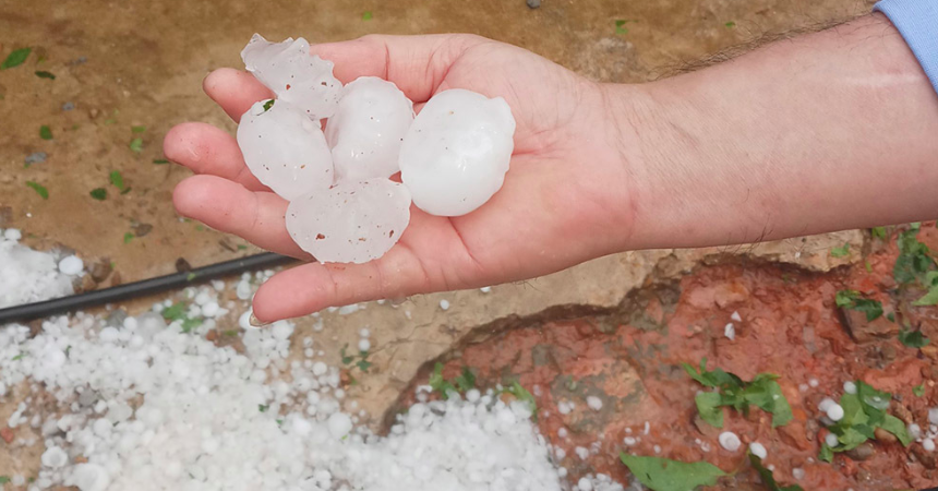
According to the National Center for Hydro-Meteorological Forecasting, on the day and night of July 2, many areas will be sunny, some places will be extremely hot with temperatures above 38 degrees Celsius; in the evening and at night there will be thunderstorms, beware of the possibility of tornadoes, lightning, hail and strong gusts of wind.
From the evening of July 2 to the morning of July 4, the mountainous and midland areas of the North will have moderate rain, heavy rain and thunderstorms, locally very heavy rain with rainfall ranging from 40-80mm, locally over 150mm. The Northern Delta will have showers and thunderstorms, locally heavy rain with rainfall ranging from 15-30mm, locally over 80mm.
In addition, in the evening and night of July 2, the area from Khanh Hoa to Ninh Thuan, the Central Highlands and the South will have scattered showers and thunderstorms, locally heavy rain with rainfall from 15-30mm, locally over 70mm.
Warning, from the afternoon of July 4, heavy rain in the mountainous and midland areas of the North is likely to gradually decrease. The risk level of natural disasters due to heavy rain, tornadoes, lightning, and hail is level 1.
Mountainous areas are at risk of flash floods, landslides and flooding in low-lying areas. Heavy rain in a short period of time can cause flooding in urban areas. Thunderstorms can cause tornadoes, lightning, hail and strong gusts of wind.
At sea, currently the central and southern East Sea (including the Truong Sa sea area), the sea area from Binh Thuan to Ca Mau has scattered showers and thunderstorms.
Forecast, on the day and night of July 2, the central East Sea area, the southern East Sea area (including the sea area of Truong Sa), the sea area from Binh Thuan to Ca Mau, Ca Mau to Kien Giang and the Gulf of Thailand will have scattered showers and thunderstorms, with the possibility of tornadoes and strong gusts of wind of level 6-7, beware of wave heights sometimes increasing to over 2m.
In addition, in the northern Gulf of Tonkin on the night of July 2, there will be strong southerly winds of level 5, sometimes level 6, gusting to level 7-8, waves 1.5-2.5m high, rough seas. All vessels operating in the above areas are at high risk of being affected by tornadoes, strong gusts of wind and big waves.
Weather in the regions during the day and night of July 2: The Northwest region will be sunny during the day, with hot sun in Hoa Binh. In the afternoon and evening, there will be moderate rain, heavy rain, thunderstorms, and locally very heavy rain. Thunderstorms may cause tornadoes, lightning, hail, and strong gusts of wind. The lowest temperature is 25-28 degrees Celsius, with some places below 24 degrees Celsius. The highest temperature is 31-34 degrees Celsius, with Hoa Binh at 35-36 degrees Celsius.
In the Northeast, there will be showers and thunderstorms in some places during the day, especially in the plains where it will be hot and sunny, with showers and scattered thunderstorms in the evening and at night, with some places having heavy rain. In the mountainous and midland areas, there will be moderate rain, heavy rain, thunderstorms, and some places having very heavy rain. During the thunderstorms, there is a possibility of tornadoes, lightning, hail, and strong gusts of wind. Wind from the South to the Southeast at level 2-3. The lowest temperature is 25-28 degrees Celsius, in the mountainous areas, some places below 24 degrees Celsius. The highest temperature is 31-34 degrees Celsius, especially in the plains where it will be 35-37 degrees Celsius.
Hanoi capital is hot during the day, with showers and scattered thunderstorms in the evening and at night, with heavy rain in some places. Thunderstorms are likely to have tornadoes, lightning, hail and strong gusts of wind. South to Southeast wind level 2-3. Lowest temperature 26-28 degrees Celsius. Highest temperature 35-37 degrees Celsius.
Provinces from Thanh Hoa to Thua Thien - Hue will have hot and extremely hot days, with scattered showers and thunderstorms in the evening and at night. There is a possibility of tornadoes, lightning, hail and strong gusts of wind during thunderstorms. Southwest wind level 2-3. Lowest temperature 27-30 degrees Celsius. Highest temperature 35-38 degrees Celsius, some places above 38 degrees Celsius.
Provinces and cities from Da Nang to Binh Thuan will have hot and extremely hot days, with showers and thunderstorms in some places in the afternoon and evening. In the South, there will be scattered showers and thunderstorms, with some places having heavy rain. During thunderstorms, there is a possibility of tornadoes, lightning, hail and strong gusts of wind. Southwest wind level 2-3. Lowest temperature 26-29 degrees Celsius, in the South some places below 26 degrees Celsius. Highest temperature 35-38 degrees Celsius, in the North some places above 38 degrees Celsius.
In the Central Highlands, there will be scattered showers and thunderstorms during the day, scattered showers and thunderstorms in the evening and at night, with some places experiencing heavy rain. During thunderstorms, there is a possibility of tornadoes, lightning, hail and strong gusts of wind. Southwest wind level 2-3. Lowest temperature 21-24 degrees Celsius. Highest temperature 30-33 degrees Celsius, some places above 33 degrees Celsius.
In the Southern region, there will be scattered showers and thunderstorms during the day, scattered showers and thunderstorms in the evening and at night, with some places experiencing heavy rain. During thunderstorms, there is a possibility of tornadoes, lightning, hail and strong gusts of wind. West to Southwest wind level 2-3. Lowest temperature 24-27 degrees Celsius. Highest temperature 31-34 degrees Celsius.
According to the Communist Party of Vietnam Electronic Newspaper
Source

![[Photo] Prime Minister Pham Minh Chinh commends forces supporting Myanmar in overcoming earthquake consequences](https://vstatic.vietnam.vn/vietnam/resource/IMAGE/2025/4/10/e844656d18bd433f913182fbc2f35ec2)

![[Photo] April Festival in Can Tho City](https://vstatic.vietnam.vn/vietnam/resource/IMAGE/2025/4/10/bf5ae82870e648fabfbcc93a25b481ea)
![[Photo] Opening of the 11th Conference of the 13th Party Central Committee](https://vstatic.vietnam.vn/vietnam/resource/IMAGE/2025/4/10/f9e717b67de343d7b687cb419c0829a2)


![[Photo] Reliving the heroic memories of the nation in the program "Hanoi - Will and belief in victory"](https://vstatic.vietnam.vn/vietnam/resource/IMAGE/2025/4/10/19ce7bfadf0a4a9d8e892f36f288e221)


Comment (0)