
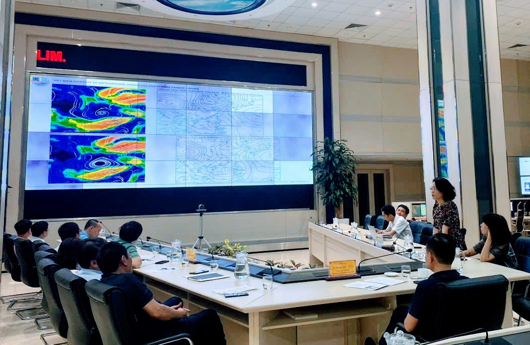
On the evening of July 15, Director General of the General Department of Hydrometeorology (GDM) Tran Hong Thai chaired a meeting to proactively respond to the tropical depression strengthening into storm No. 1 (storm TALIM).
Mr. Tran Hong Thai said that this is a strong storm in the context of El Nino, so it will have many impacts. To respond to the storm, there needs to be close coordination between agencies, and strict implementation of information provision and sharing between agencies and localities to promptly respond to the complex developments of the storm.
At the same time, it is necessary to receive opinions from all levels and localities; information to people needs to be clear, specific, easy to understand, early and timely to limit damage to people and property.

Mr. Nguyen Van Huong - Head of Weather Forecast Department (National Center for Hydro-Meteorological Forecasting) said that storm No. 1 is moving mainly in the West-Northwest direction, at a speed of 10 - 15km/h.
The storm is forecast to move into the Gulf of Tonkin in the early morning of July 18 and will directly affect our country that night.
Storm No. 1 caused heavy and very heavy rain in many places from July 18 such as the Northern region, Thanh Hoa, Nghe An with forecasted rainfall from 200 - 300mm; the Northeast region had some places with heavy rain over 500mm; the Northwest region had rainfall from 100 - 200mm, some places over 300mm.
After July 21, the Northern region and Thanh Hoa and Nghe An provinces will be affected by the post-storm circulation, so there will continue to be heavy rain with forecasted rainfall from 70 - 150mm, in some places over 250mm.
Ms. Pham Thi Thanh Nga - Director of the Institute of Hydrometeorology and Climate Change also agreed with the assessment of the National Center for Hydrometeorological Forecasting that storm No. 1 will gradually increase in intensity and reach its peak when entering the Gulf of Tonkin around the morning of July 18.
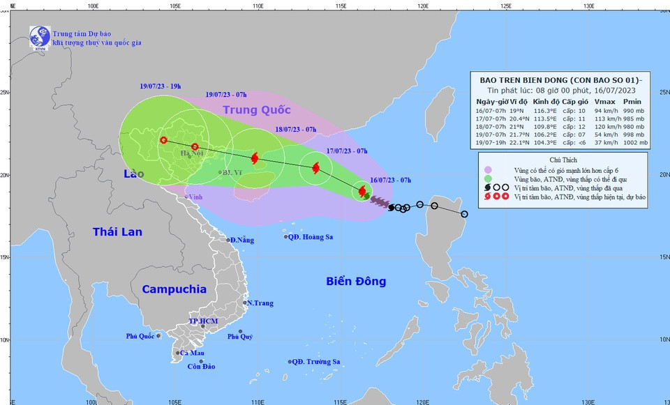
The National Center for Hydro-Meteorological Forecasting said that at 7:00 a.m. on July 16, the center of the storm was located at approximately 19.0 degrees North latitude; 116.3 degrees East longitude, approximately 670 km East Southeast of Leizhou Peninsula (China). The strongest wind near the center of the storm was level 9-10 (75-102 km/h), gusting to level 13.
This agency assesses the storm's developments in the next 24 to 72 hours:
At 7:00 a.m. on July 17, the storm moved northwest at a speed of about 10-15 km/h. The storm is likely to strengthen. The center of the storm is at about 20.4N-113.5E; in the northern sea area of the North East Sea, about 340km east-southeast of the Leizhou Peninsula (China). The strongest wind near the center of the storm is level 11, gusting to level 14. The dangerous area at sea in the next 24 hours is from 17.0-22.0N; east of longitude 112.0E. Disaster risk level 3: north of the North East Sea area.
At 7:00 a.m. on July 18, storm No. 1 moved in the West Northwest direction, at about 15 km/h. The center of the storm was at about 21.0N-109.8E; in the Leizhou peninsula (China). The strongest wind near the center of the storm was at level 12, gusting to level 15. The dangerous area at sea in the next 48 hours was north of latitude 18.0N; 108.5-117.5E. Disaster risk level 3: north of the North East Sea.
At 7:00 a.m. on July 19, storm No. 1 moved in the West-Northwest direction, at about 15 km/h and gradually weakened. The center of the storm was at about 21.7N-106.2E; in the Northeast region. The strongest wind near the center of the storm was at level 6-7, gusting to level 9. Disaster risk level 3: Northwest of the North East Sea and North Gulf of Tonkin.
In the next 72 - 84 hours, the tropical depression will move mainly in the West Northwest direction, traveling 15km per hour and continue to weaken.
Regarding the impact of the storm in the next 24 hours, the sea area north of the North East Sea will have strong winds of level 7, near the storm center will have strong winds of level 9-10, then increase to level 11, gusting to level 14. The sea is very rough. Rising water, big waves. The sea area north of the North East Sea will have waves 5-7m high.
The Hydrometeorological Forecasting Agency warns that on the day and night of July 17, the northern sea area of the North East Sea will have strong winds of level 11-12, gusting to level 15; waves of 6-8m; very rough seas.
Source
![[Photo] Promoting friendship, solidarity and cooperation between the armies and people of the two countries](https://vstatic.vietnam.vn/vietnam/resource/IMAGE/2025/4/17/0c4d087864f14092aed77252590b6bae)
![[Photo] Nhan Dan Newspaper announces the project "Love Vietnam so much"](https://vstatic.vietnam.vn/vietnam/resource/IMAGE/2025/4/17/362f882012d3432783fc92fab1b3e980)
![[Photo] National Assembly Chairman Tran Thanh Man meets with outstanding workers in the oil and gas industry](https://vstatic.vietnam.vn/vietnam/resource/IMAGE/2025/4/17/1d0de4026b75434ab34279624db7ee4a)

![[Photo] Closing of the 4th Summit of the Partnership for Green Growth and the Global Goals](https://vstatic.vietnam.vn/vietnam/resource/IMAGE/2025/4/17/c0a0df9852c84e58be0a8b939189c85a)
![[Photo] General Secretary To Lam receives French Ambassador to Vietnam Olivier Brochet](https://vstatic.vietnam.vn/vietnam/resource/IMAGE/2025/4/17/49224f0f12e84b66a73b17eb251f7278)


![[Photo] Welcoming ceremony for Chinese Defense Minister and delegation for friendship exchange](https://vstatic.vietnam.vn/vietnam/resource/IMAGE/2025/4/17/fadd533046594e5cacbb28de4c4d5655)


![[Video] Viettel officially puts into operation the largest submarine optical cable line in Vietnam](https://vstatic.vietnam.vn/vietnam/resource/IMAGE/2025/4/17/f19008c6010c4a538cc422cb791ca0a1)


Comment (0)