
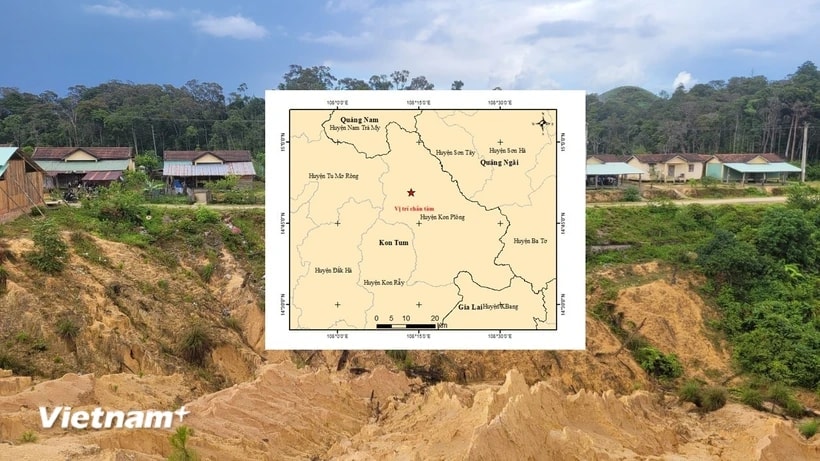
On the morning of April 1, information from the Earthquake Information and Tsunami Warning Center - Institute of Earth Sciences (Vietnam Academy of Science and Technology) said that in March 2025, the whole country experienced 26 earthquakes with magnitudes ranging from 2.5 to 3.7, mainly concentrated in the "earthquake hotspot" area in Kon Tum province.
Updated data from the Earthquake Information and Tsunami Warning Center - Institute of Earth Sciences, shows that out of the total 26 earthquakes that occurred in March, 23 occurred in Kon Plong district, Kon Tum province; 3 earthquakes occurred in Nam Tra My district, Quang Nam province (Nam Tra My district has been an "earthquake hotspot" since 2012, when Song Tranh 2 Hydropower Plant stored water to generate electricity).
In particular, some days had many consecutive earthquakes such as: On March 2, there were 3 consecutive earthquakes with magnitudes from 3.0 to 3.2; on March 6, there were 3 earthquakes with magnitudes from 2.6 to 3.7; on March 18, there were 3 earthquakes with magnitudes from 2.6 to 3.0; on March 25, there were 3 earthquakes with magnitudes from 2.5 to 2.9...
Notably, on March 31, there were 5 consecutive earthquakes with magnitudes ranging from 2.6 to 3.1. All the earthquakes that occurred on this day were concentrated in Kon Plong district.
Notably, on March 28, although the Earthquake and Tsunami Warning Center only recorded a magnitude 3.0 earthquake occurring in Kon Plong, due to the impact of aftershocks from the strong earthquake that occurred in Myanmar, people in several high-rise buildings in many provinces and cities across the country (especially Hanoi and Ho Chi Minh City) still felt the shaking clearly.
According to the Institute of Earth Sciences, in Vietnam, recently, most earthquakes have been small earthquakes, stimulated earthquakes, caused by the water storage process of hydroelectric reservoirs affecting the active fault system below.
Some factors related to earthquake stimulation such as reservoir water level, reservoir filling rate, total water volume will affect earthquakes. However, scientists note that these effects can occur after several months, several years when enough water seeps down below.
In the past 10 years, areas with frequent earthquakes have been concentrated mainly in provinces such as Kon Tum and Quang Nam. In particular, Nam Tra My district is adjacent to Kon Plong district - this is a "hot spot" of earthquake stimulation at the present time in the Central Highlands region.
Statistics from the Institute of Earth Sciences show that earthquakes have occurred frequently in Kon Plong from 2021 to present.
Previously, in February 2025, Kon Plong and Nam Tra My also had 26 earthquakes with magnitudes from 2.5 to 3.7; of which 19 occurred in Kon Plong district, the remaining 7 earthquakes occurred in Nam Tra My district.
A representative of the Institute of Earth Sciences said that the earthquake situation in Kon Plong and Nam Tra My districts is still ongoing and may affect key construction areas, especially the epicenter.
Therefore, local authorities need to update information regularly to develop seismic design plans for all types of buildings.
According to the regulations on "earthquake and tsunami prevention and control regulations," when receiving news of an earthquake or tsunami warning, people's committees at all levels must notify the people in the area; organize evacuation instructions and mobilize local means to help people evacuate to safety while taking measures to ensure security and order in the area.
Upon receiving news of an earthquake or tsunami warning, all citizens in the affected area must proactively evacuate from the dangerous area to ensure safety.
TH (according to VNA)Source: https://baohaiduong.vn/xay-ra-26-tran-dong-dat-trong-thang-3-tai-cac-diem-nong-o-kon-tum-quang-nam-408509.html
![[Photo] Prime Minister Pham Minh Chinh receives Deputy Prime Minister of the Republic of Belarus Anatoly Sivak](https://vstatic.vietnam.vn/vietnam/resource/IMAGE/2025/4/2/79cdb685820a45868602e2fa576977a0)

![[Photo] General Secretary To Lam receives Russian Ambassador to Vietnam](https://vstatic.vietnam.vn/vietnam/resource/IMAGE/2025/4/2/b486192404d54058b15165174ea36c4e)
![[Photo] Prime Minister Pham Minh Chinh receives CEO of Standard Chartered Group](https://vstatic.vietnam.vn/vietnam/resource/IMAGE/2025/4/2/125507ba412d4ebfb091fa7ddb936b3b)


![[Podcast] News on March 27, 2025](https://vstatic.vietnam.vn/vietnam/resource/IMAGE/2025/4/2/de589137cda7441eb0e41ee218b477e8)


Comment (0)