
TPO - The meteorological agency predicts that from now until the end of February, the Ho Chi Minh City area will continue to have unseasonal rains caused by high-altitude easterly wind disturbances.
TPO - The meteorological agency predicts that from now until the end of February, the Ho Chi Minh City area will continue to have unseasonal rains caused by high-altitude easterly wind disturbances.
On the afternoon of February 13, the Southern Hydrometeorological Station reported that Ho Chi Minh City and the provinces and cities in the South are currently experiencing unseasonal rain. The reason is that the continental cold high pressure is strengthening to the South. The low pressure trough with an axis of 10-13 degrees North latitude connects with the tropical low pressure operating in the western sea area of the central East Sea. Above, the subtropical high pressure with an axis crossing the Central region is weak.
Monitoring satellite cloud images, weather radar images and lightning positioning shows that on the afternoon of February 13, the thunderstorm area was developing and causing rain with thunderstorms and lightning in Can Gio and Nha Be districts.
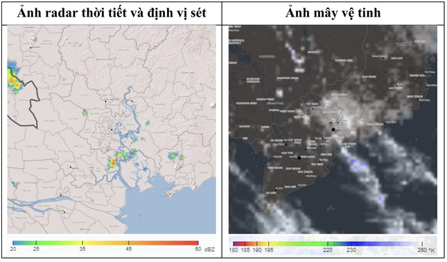 |
Satellite cloud images and weather radar, lightning location in Ho Chi Minh City area on the afternoon of February 13. Source: Southern Hydrometeorological Station |
It is forecasted that in the afternoon of February 13, thunderstorms will continue to develop, causing showers, accompanied by thunderstorms and lightning in the above districts, then expanding to other neighboring areas. Rainfall is generally from 2-10mm, in some places over 10mm. During thunderstorms, beware of strong gusts of wind of about level 5-7 (8-17m/s), heavy rain causing localized flooding.
Regarding the weather situation in Ho Chi Minh City in the next 10 days, the Southern Hydrometeorological Station said that the cold air will gradually weaken, and around the night of February 15-16, it is likely to strengthen and shift east again, then stabilize and gradually weaken.
Above, the subtropical high pressure system with an axis over the Central region is stable. The tropical low pressure system moves northwest and gradually weakens. The equatorial low pressure trough weakens and gradually fades away. The easterly wind disturbance above (causing rain) operates better from around February 18-20.
Based on the above main weather patterns, the Southern Hydrometeorological Station forecasts that tomorrow (February 14) in Ho Chi Minh City, there will be a 60-70% chance of rain depending on the area. During the period from February 15 to 20, there will be scattered showers in some places for a few days.
 |
Prolonged unseasonal rain caused flooding at the Nguyen Van Linh - Nguyen Huu Tho intersection, District 7, Ho Chi Minh City on the morning of February 13. Photo: MH |
Despite unseasonal rain, the Southern Hydrometeorological Station also forecasts that Ho Chi Minh City will have some locally hot days from mid to late February.
Specifically, in the last week of February, the cold air is still quite strong, but the strengthening waves are less frequent and mainly strengthen from the east. Therefore, the temperature in Ho Chi Minh City will increase significantly and there will be a few hot days with the highest temperature above 35 degrees Celsius.
In addition, the Indo-Burma low pressure area is forecast to become more active in the middle and late February, and will continue to expand southward. Heat waves generated from this low pressure area will begin to affect the regional weather and cause heat waves in the city center for a few days.


Source: https://tienphong.vn/tphcm-tiep-tuc-co-nhieu-dot-mua-trai-mua-trong-thang-2-post1716886.tpo


Comment (0)