
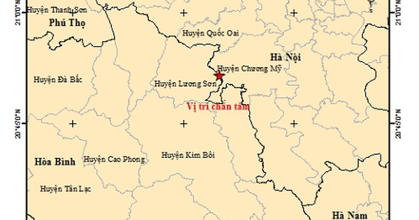
The Earthquake Information and Tsunami Warning Center (Institute of Geophysics) has just issued a warning about an earthquake in Chuong My, Hanoi.
Specifically, according to information from the Earthquake Information and Tsunami Warning Center (Institute of Geophysics), the earthquake in Chuong My district, Hanoi occurred at 12:52:41 (GMT), February 3, 2025, or 19:52:41, February 3, 2025 (local time).
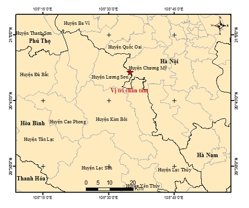
Map of earthquake epicenter in Hanoi. Photo: Institute of Geophysics
Earthquake coordinates: 20.860N-105.582E. Depth: about 8.0km. Magnitude: M = 2.6. Disaster risk level: 0.
The Earthquake Information and Tsunami Warning Center - Institute of Geophysics is continuing to monitor this earthquake.
Previously, in March 2024, a magnitude 4 earthquake occurred in My Duc district, Hanoi, with a focal depth of about 16km. The earthquake occurred in the Red River - Lo River - Chay River fault zone. When these faults accumulate enough energy, an earthquake occurs.
According to Dr. Nguyen Xuan Anh, Director of the Institute of Geophysics, the Red River - Lo River - Chay River fault zone has experienced earthquakes in the past. In Hanoi, in the 12th century, there was a magnitude 8 earthquake.
The Director of the Institute of Geophysics also said that it is necessary to study the Red River fault segment to assess earthquake hazards in more detail. The Hanoi area needs to conduct an earthquake risk assessment, and at the same time propose to set up a number of monitoring devices in high-rise buildings in the city to quantitatively assess the level of shaking caused by earthquakes.
According to Mr. Xuan Anh, there needs to be a more detailed earthquake assessment map for Hanoi, which updates new earthquakes, from which scenarios for assessing earthquake hazards in inner-city districts can be developed to serve the seismic resistance of infrastructure works.
Source: https://danviet.vn/nong-dong-dat-o-ha-noi-20250203215318698.htm


Comment (0)