
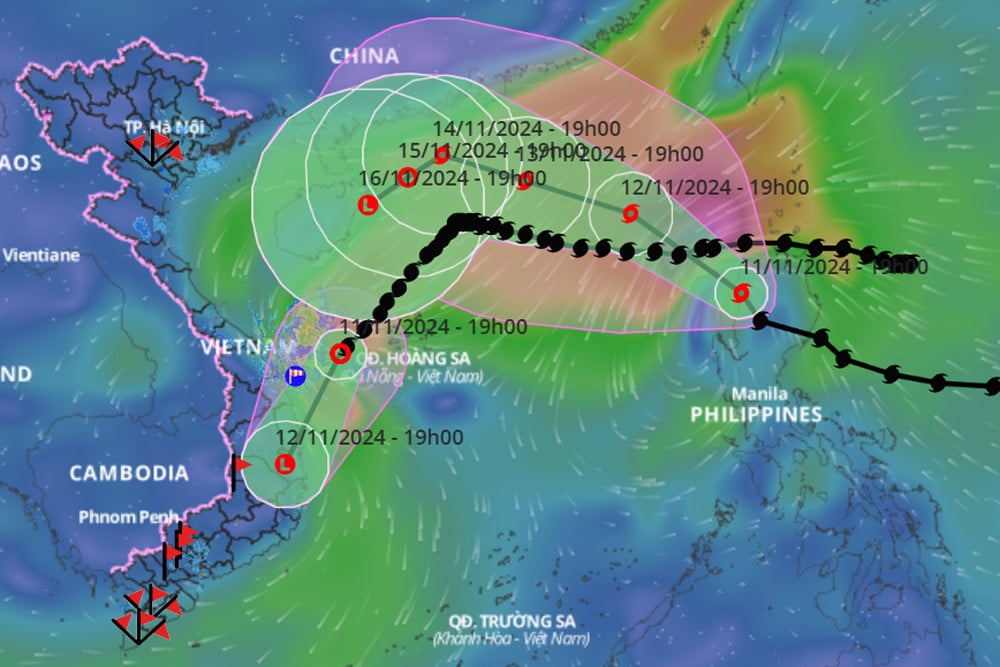
Around tonight (November 11), storm Toraji entered the East Sea and became storm number 8. At the same time, storm number 7 Yinxing, after moving into the waters west of the Hoang Sa archipelago, weakened into a tropical depression.
According to the National Center for Hydro-Meteorological Forecasting, tonight (November 11), after moving into the western sea area of the Hoang Sa archipelago, storm No. 7 Yinxing weakened into a tropical depression.
At 7:00 p.m., the strongest wind near the center of the tropical depression is level 7 (50-61 km/h), gusting to level 9. Moving southwest, speed 15-20 km/h.
In the next 24 hours, the tropical depression will maintain its direction of movement at a speed of about 15km/h, weakening into a low pressure area over the mainland provinces of Quang Ngai - Phu Yen.
Due to the influence of storm No. 7, Ly Son Island (Quang Ngai) has strong winds of level 6, gusting to level 7.
From tonight to tomorrow night (November 12), the area from Thua Thien Hue to Phu Yen will have moderate rain, heavy rain, locally very heavy rain and thunderstorms with rainfall from 70-150mm, locally over 250mm. Warning of the risk of local heavy rain (>100mm/6 hours).
At the same time, tomorrow day and night, the Central Highlands will have moderate rain, heavy rain, locally very heavy rain and thunderstorms with rainfall from 40-90mm, locally over 180mm. From November 13, heavy rain will gradually decrease.
Also due to the influence of storm No. 7, the sea area of Hoang Sa archipelago has strong winds of level 6-7, waves 2-4m high; rough seas.
The sea area off Thua Thien Hue to Binh Dinh (including the sea area of Ly Son island district) has strong winds of level 6-7, gusts of level 9, waves 2-4m high; rough seas.
Also at 7pm tonight, the eye of storm Toraji is on the west coast of Luzon Island (Philippines). The strongest wind near the eye of the storm is level 11-12 (103-133km/h), gusting to level 14. Moving northwest at a speed of about 20km/h. It is forecasted that tonight or early tomorrow morning (November 12), storm Toraji will enter the East Sea and become storm number 8 .
Storm forecast (next 24 to 72 hours) :
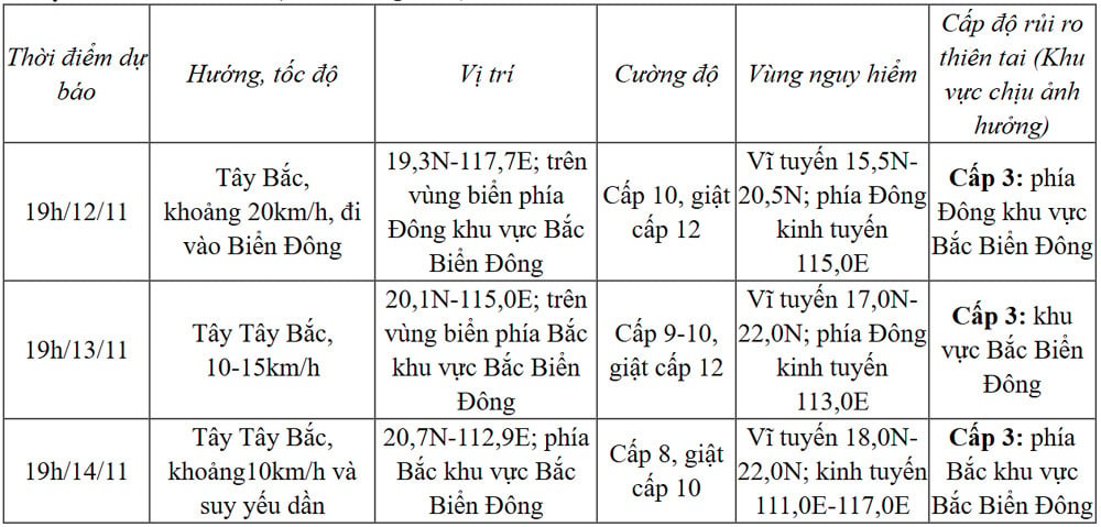
From the next 72 to 120 hours, storm No. 8 Toraji moved in the West Southwest direction, about 5km per hour, and continued to weaken.
Due to the influence of storm Toraji, later storm No. 8, the weather in the eastern sea area of the North East Sea is strong wind level 6-7, then increasing to level 8, near the storm center level 9-10, gust level 12, waves 3-5m high, near the storm center 5-7m; very rough seas.
Ships operating in the above mentioned dangerous areas are susceptible to the effects of storms, whirlwinds, strong winds and large waves.
The meteorological agency added that the East Sea is experiencing a situation of overlapping storms. It is forecasted that after storm number 7 and storm number 8, the East Sea may welcome storm number 9 in the near future, when off the coast of the Philippines there is a tropical depression and a storm.
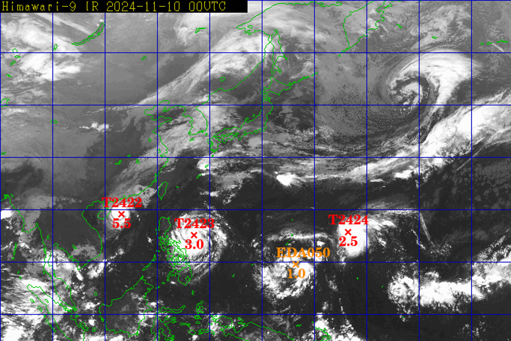
Series of 3 storms and tropical depressions, possibility of storm number 9

Source: https://vietnamnet.vn/bao-toraji-dang-vao-bien-dong-bao-so-7-suy-yeu-thanh-ap-thap-nhiet-doi-2341012.html


Comment (0)