
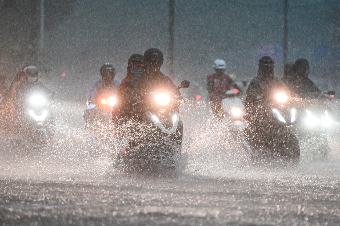
Storm No. 10 has been moving slowly for the past 6 hours and is forecast to weaken into a tropical depression. The influence of the circulation will cause showers and thunderstorms in Ho Chi Minh City and some southern provinces and cities.
According to the National Center for Hydro-Meteorological Forecasting, in the past 6 hours, storm No. 10 (international name Pabuk) has barely moved.
As of 1 p.m. on December 24, the storm's eye was still in the southwest sea area of the Central East Sea. The strongest wind near the storm's eye was level 8 (62-74 km/h), gusting to level 10; moving in a West Southwest direction at a speed of about 5 km/h.
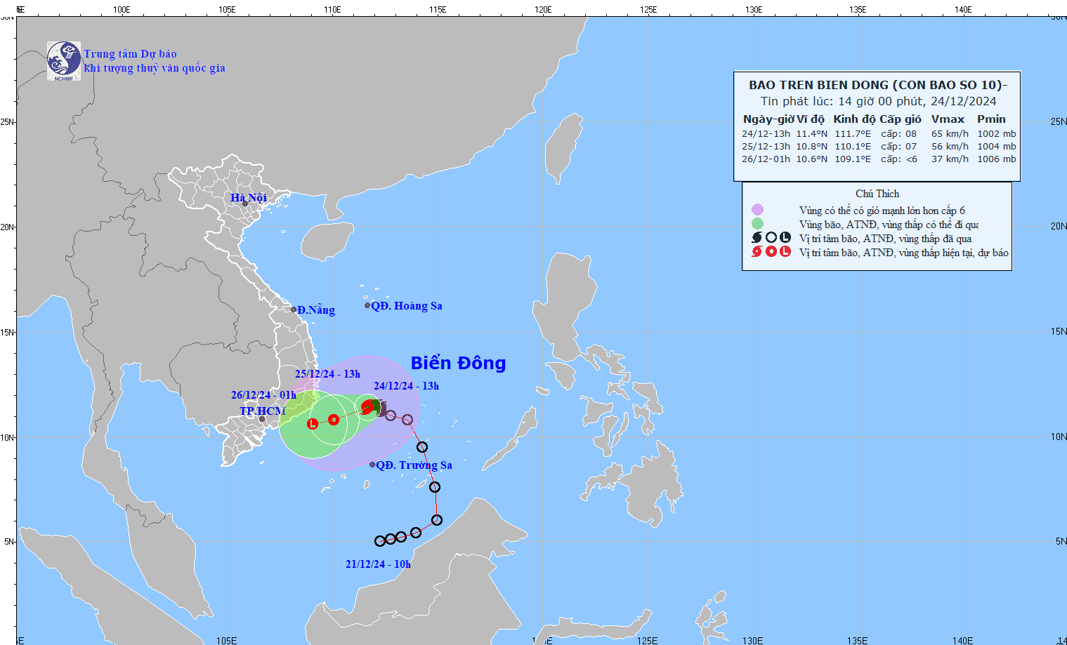
Storm No. 10 moves slowly in the East Sea. Source: NCHMF
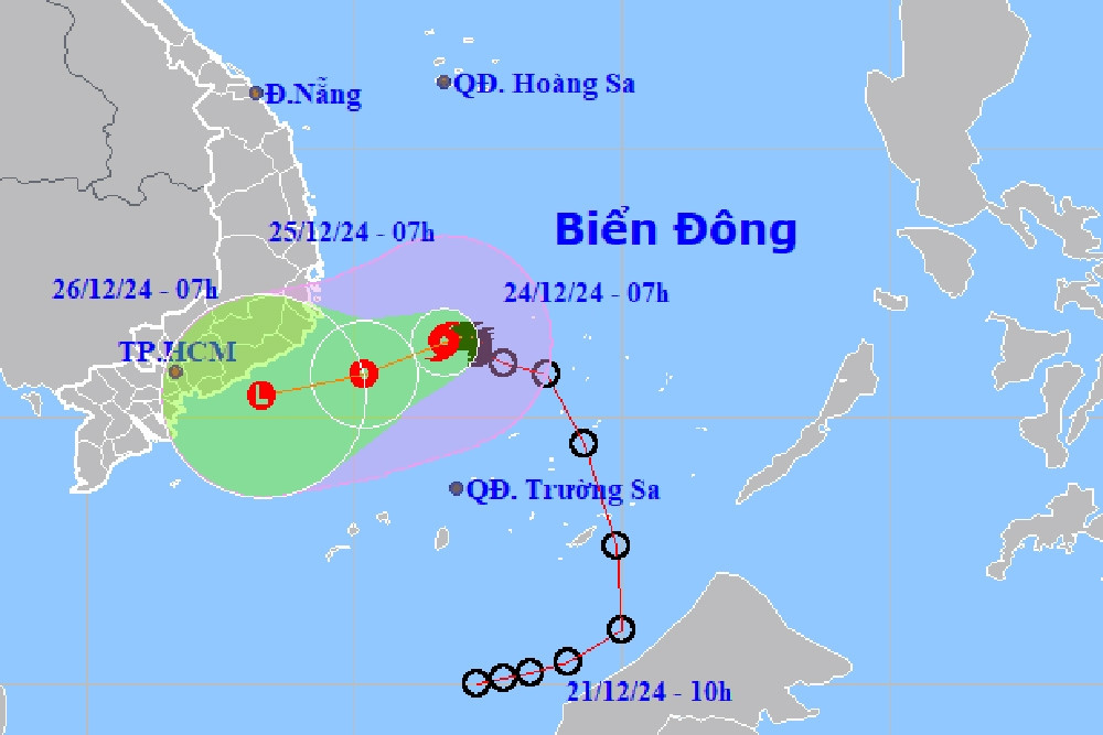
At 1:00 p.m. on December 25, the storm moved west-southwest at 5-10km/h and gradually weakened into a tropical depression over the sea from Khanh Hoa to Binh Thuan with the strongest wind at level 6-7, gusting to level 9.
About 12 hours later, the tropical depression maintained its direction of movement, at a speed of about 10km/h, and gradually weakened into a low pressure area over the sea from Ninh Thuan to Ba Ria - Vung Tau with winds below level 6.
The sea area southwest of the Central East Sea and the sea area northwest of the South East Sea (including the sea area northwest of Truong Sa archipelago) has strong winds of level 6-7, the area near the storm center has strong winds of level 8, gusts of level 10, waves 4-6m high; rough seas. The sea area from Khanh Hoa to Binh Thuan (including Phu Quy island) has strong winds of level 6, sometimes level 7, gusts of level 8-9, waves 3-6m high; rough seas.
Ships operating in the above mentioned dangerous areas are susceptible to the effects of storms, whirlwinds, strong winds and large waves.
Thus, according to the forecast of the meteorological agency, storm No. 10 will weaken and become a low pressure area at sea, with little chance of making landfall. However, the influence of the storm's circulation combined with the northeast monsoon will cause rain in the Central and South Central regions, the Eastern Central Highlands and the Southeast.
The Southern Regional Hydrometeorological Station said that the weather in the South will be cloudy, sunny during the day, with scattered showers in the evening, moderate rain in some places, heavy rain and thunderstorms in some places.
Ho Chi Minh City weather is cloudy, sunny during the day, no rain at night; light fog in the early morning; showers and thunderstorms in some places in the late afternoon and evening.
The Ministry of Agriculture and Rural Development issued a telegram requesting coastal provinces of Phu Yen - Ca Mau to monitor the storm's developments, guide ships to move out of dangerous areas, and prepare rescue vehicles when requested.
Storm No. 10 weakens, combines cold air and heavy rain from Da Nang to the south
Storm No. 10 enters the sea area from Phu Yen to Ba Ria - Vung Tau, where is the rain center?

Hanoi weather for the next 3 days: Cold air shifts to the east, coldest night 13 degrees
Source: https://vietnamnet.vn/bao-so-10-it-dich-chuyen-6-gio-qua-tphcm-xuat-hien-mua-giong-2355918.html
![[Photo] Prime Minister Pham Minh Chinh receives Swedish Minister of International Development Cooperation and Foreign Trade](https://vphoto.vietnam.vn/thumb/1200x675/vietnam/resource/IMAGE/2025/5/12/ae50d0bb57584fd1bbe1cd77d9ad6d97)
![[Photo] Prime Minister Pham Minh Chinh starts construction of vital highway through Thai Binh and Nam Dinh](https://vphoto.vietnam.vn/thumb/1200x675/vietnam/resource/IMAGE/2025/5/12/52d98584ccea4c8dbf7c7f7484433af5)


![[Photo] Prime Minister Pham Minh Chinh works with the Standing Committee of Thai Binh Provincial Party Committee](https://vphoto.vietnam.vn/thumb/1200x675/vietnam/resource/IMAGE/2025/5/12/f514ab990c544e05a446f77bba59c7d1)


Comment (0)