
Internet Technology
- Saturday, April 29, 2023 10:40 (GMT+7)
- 10:40 April 29, 2023
Google Maps reported traffic congestion and jams on highways and national roads from Ho Chi Minh City to many neighboring provinces on the morning of April 29.
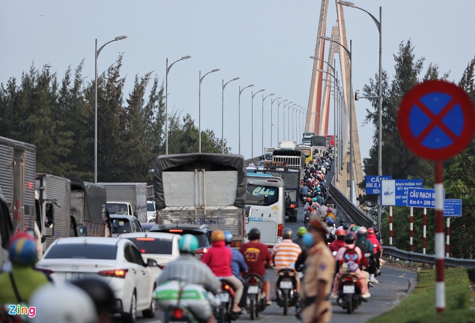 |
Traffic jam about 2km long on Highway 60 on the road leading to Rach Mieu Bridge on Tien Giang bank. Photo: Hoang Giam . |
Updated map data from Google Maps shows severe congestion on many routes originating from major cities. Combining information shared by users, the platform calculates travel times plus 1-5 hours for familiar routes.
On the bus back to her hometown, Ms. Bao Trang, a resident of Tan Binh District, Ho Chi Minh City, said she was very frustrated because after more than 4 hours of travel, the vehicle still had not left Dong Nai province. "Google Maps shows that the route from Ho Chi Minh City to Phan Thiet has many dark red traffic jams. I don't know when I will get home," the user shared.
This is also the situation of many people who choose to return to their hometowns and travel by road on April 29. Today is the first day of a 5-day long break during the April 30-May 1 holiday this year. Therefore, a large number of people from big cities such as Hanoi and Ho Chi Minh City are moving away from the central area. This leads to prolonged congestion on major traffic routes in the morning of the same day.
  |
Google Maps reports dozens of traffic jams on the main traffic route from Ho Chi Minh City to neighboring provinces. Photo: Xuan Sang. |
For example, the route from Ho Chi Minh City to Can Tho, traveling by car is 167 km long, estimated by Google Maps to take about 3 hours and 32 minutes. However, on this route, there are 4 local congestion points, moving very slowly. The total waiting time on these sections is 1 hour and 14 minutes. Thus, users can spend nearly 5 hours traveling on the highway.
Similarly, for the Ho Chi Minh City - Phan Thiet route, at the city gate and in Dong Nai province, there are 7 local congestion points along the Ho Chi Minh City - Long Thanh - Dau Giay Expressway and National Highway 1A. The total waiting time at these points, according to Google Maps' calculations, is 90 minutes. In addition, there are many slow-moving sections on the route, with vehicles congested.
In addition, Google Maps has not updated the Long Thanh - Phan Thiet expressway, which was inaugurated on the morning of April 29. Therefore, the platform does not guide users through this route.
In Hanoi, the southern gateways (Ring Road 3 via Thanh Tri Bridge), eastern (Vinh Tuy Bridge) and northern (Thang Long Bridge to National Highway 2) all show prolonged congestion. Only the western gateway (via Thang Long Avenue) has clear roads.
In particular, the Hanoi - Ninh Binh route is only 94 km long but has 5 jams, making it impossible to move. The total waiting time at these locations is nearly 2 hours. The national highway section is displayed by the app in orange and dark red, showing slow to very slow movement speed.
 |
Less than 100 km from Hanoi to Ninh Binh, there are 5 traffic jams that last up to 2 hours. Photo: Xuan Sang. |
For motorbikes, Google Maps directs users to side streets and alleys along the main route or further away to save time.
The app displays green, orange, red, and brown colors to classify real-time road travel speeds. Orange, red, and brown indicate slow to very slow travel. Traffic data is also used to estimate travel time between two points.
This Google Maps feature works by collecting data from users who share their location on the app. This way, the company provides real-time traffic updates on Maps.
Before using a user’s location, Google uses cameras and traffic sensors installed by authorities to update traffic conditions. These devices use radar technology or infrared lasers to scan the overall volume of vehicles and their speeds.
However, these tools are only available in certain roads and countries. Therefore, Google Maps' traffic coverage is not widespread.
If there are a lot of people moving slowly on the same road, a large amount of data at the same location is provided to Google. From there, the app has enough information to display a yellow line to indicate slow-moving vehicles, or red or brown if there are obstacles ahead.
Google's two founders did it all themselves
Telling the stories of 25 entrepreneurs around the world, the book "What did they do to change the world?" is both a "treasure trove" of documents about the entrepreneurial spirit and a source of inspiration for those who want to create meaningful things themselves.
Spring Sang
Google Maps traffic jam Google Maps traffic jam
You may be interested in
Source link

![[Photo] General Secretary To Lam receives Russian Ambassador to Vietnam](https://vstatic.vietnam.vn/vietnam/resource/IMAGE/2025/4/2/b486192404d54058b15165174ea36c4e)

![[Photo] Third meeting of the Organizing Subcommittee serving the 14th National Party Congress](https://vstatic.vietnam.vn/vietnam/resource/IMAGE/2025/4/2/3f342a185e714df58aad8c0fc08e4af2)


![[Photo] Relatives of victims of the earthquake in Myanmar were moved and grateful to the rescue team of the Vietnamese Ministry of National Defense.](https://vstatic.vietnam.vn/vietnam/resource/IMAGE/2025/4/2/aa6a37e9b59543dfb0ddc7f44162a7a7)


Comment (0)