
Storm No. 6 (Tra Mi) has weakened into a tropical depression. The storm's circulation is causing heavy to very heavy rain in the area from South Ha Tinh to Thua Thien Hue. Storm Kong-rey, which formed later, is strengthening and is likely to approach the East Sea.
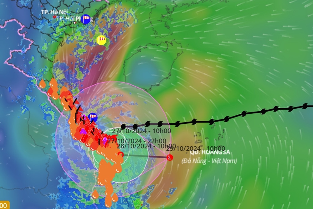
This afternoon (October 27), after moving deep into the mainland of Thua Thien Hue, Quang Nam - Da Nang provinces, storm No. 6 (storm Tra Mi) weakened into a tropical depression.
At 4 p.m., the center of the tropical depression was located on the mainland of Thua Thien Hue, Quang Nam - Da Nang provinces. The strongest wind near the center of the tropical depression was level 7, gusting to level 9. Moving in the South-Southwest direction, at a speed of about 5 km/h.
In the next 12 hours, the tropical depression moved slowly, only 3-5km/h, in the Southeast direction with intensity level 6, gusting to level 8. Then, at 13:00 on October 28, the tropical depression moved in the East direction, about 5km/h, weakening into a low pressure area in the coastal waters of Thua Thien Hue - Quang Nam.
On the same afternoon, Mr. Vu Anh Tuan, Deputy Head of Weather Forecast Department, National Center for Hydro-Meteorological Forecasting, also announced the forecasts and warnings at 5:00 p.m.
Accordingly, based on monitoring station data, this afternoon storm No. 6 entered Quang Tri - Quang Nam provinces and weakened into a tropical depression in the area of Thua Thien Hue - Quang Nam - Da Nang provinces by evening.
Mr. Tuan assessed that the tropical depression is moving south and in the coming hours it is likely to move out to sea; it is likely to weaken into a low pressure area over the central central sea.
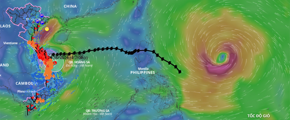
Storm Kong-rey strengthens, likely to approach East Sea
In addition, Mr. Tuan added, the center's monitoring shows that currently a storm with the international name Kong-rey is active in the offshore waters east of Lu Dong Island (Philippines).
At 1pm today, the storm was over 1,000km from shore and continued to strengthen. According to the center, the storm is likely to continue moving west and shift to the right.
“Products collected in recent sessions show that the development of this storm is tending to the left and is likely to go lower than initially assessed.
Therefore, it is not impossible that this storm will approach the East Sea area," Mr. Tuan commented.
The forecast center is closely monitoring this storm and will provide further information as it becomes available.
Heavy rain from South Ha Tinh to Thua Thien Hue
Due to the influence of storm No. 6 , Con Co Island (Quang Tri) has strong winds of level 8, gusting to level 9; Cu Lao Cham Island (Quang Nam) has strong winds of level 8, gusting to level 10; Ly Son Island (Quang Ngai) has level 6, gusting to level 7; Le Thuy (Quang Binh) has strong winds of level 7, gusting to level 9; Nam Dong (Thua Thien Hue) has strong winds of level 8, gusting to level 10; Cam Le (Da Nang) has strong winds of level 8, gusting to level 9; Son Tra (Da Nang) has strong winds of level 9, gusting to level 10.
On land from Quang Binh to Quang Nam, there are strong gusts of wind at level 6-8; areas near the center of the tropical depression have strong winds at level 6-7, gusts at level 8-9.
From last night to this afternoon, the area from Ha Tinh to Quang Nam has had heavy to very heavy rain. Total rainfall as of 4pm on October 27, generally 150-250 mm, locally over 400 mm.
It is forecasted that from now until the end of tomorrow night (October 28), in the area from South Ha Tinh to Thua Thien Hue, there will be heavy to very heavy rain with rainfall from 150-250 mm, locally over 400 mm; warning of the risk of local heavy rain (>100 mm/3 hours). The area from Da Nang to Quang Ngai and Kon Tum will have heavy rain, locally very heavy rain with rainfall from 70-150 mm, locally over 200 mm.
Water levels in many rivers above alert level 3
Mr. Phung Tien Dung, Head of Hydrological Forecasting Department, National Center for Hydro-Meteorological Forecasting, said that due to very heavy rain in the Central Central provinces, floods on rivers in Quang Binh - Quang Tri - Thua Thien Hue are rising very quickly.
This afternoon, the water level on Kien Giang River (Quang Binh) exceeded alert level 3 by 0.5m. Rivers in Quang Tri are at alert level 2-3, some rivers exceed alert level 3; rivers in Thua Thien Hue are above alert level 2, especially on Huong River.
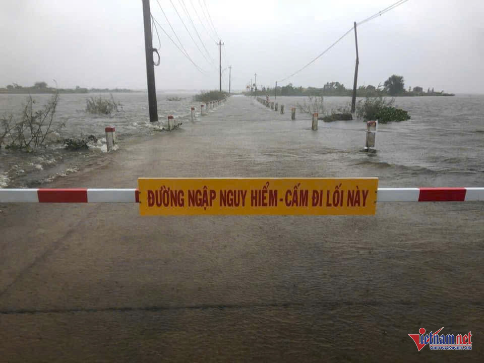
Due to heavy rain and rapid river flooding, flooding occurred in Le Thuy, Quang Ninh districts, Dong Hoi city (Quang Binh); Trieu Phong, Hai Lang, Gio Linh, Dong Ha city and Quang Tri town (Quang Tri province). In Thua Thien Hue, flooding also occurred in Phu Loc, Phu Vang, Huong Thuy, Huong Tra districts and Hue city.
According to the assessment, in the next 24 hours, the water level on Kien Giang River will continue to rise rapidly and peak at level above BĐ3. In Quang Tri, from 6-12 hours, floods on rivers will continue to rise and peak at level below BĐ3, when above BĐ3, the flood peak will remain at a high level...
Storm No. 6 with level 11 winds makes landfall in Thua Thien Hue - Da Nang, then turns out to sea

Heavy rain in Ho Chi Minh City and the Southeast due to the influence of storm No. 6

![[Photo] Close-up of Vietnam's sniffer dog team searching for earthquake victims in Myanmar](https://vstatic.vietnam.vn/vietnam/resource/IMAGE/2025/4/1/d4949a0510ba40af93a15359b5450df2)
![[Photo] Prime Minister Pham Minh Chinh meets with King Philippe of Belgium](https://vstatic.vietnam.vn/vietnam/resource/IMAGE/2025/4/1/be2f9ad3b17843b9b8f8dee6f2d227e7)

![[Photo] President Luong Cuong and King Philippe of Belgium visit Thang Long Imperial Citadel](https://vstatic.vietnam.vn/vietnam/resource/IMAGE/2025/4/1/cb080a6652f84a1291edc3d2ee50f631)

![[Photo] General Secretary To Lam receives King Philippe of Belgium](https://vstatic.vietnam.vn/vietnam/resource/IMAGE/2025/4/1/e5963137a0c9428dabb93bdb34b86d7c)


![[6pm News] Of the 40 newly discovered gold mines, 4 are in Thanh Hoa](https://vstatic.vietnam.vn/vietnam/resource/IMAGE/2025/4/1/08644991aa1b4030a549159f2f87c0d6)


![[Photo] Myanmar's capital in disarray after the great earthquake](https://vstatic.vietnam.vn/vietnam/resource/IMAGE/2025/4/1/7719e43b61ba40f3ac17f5c3c1f03720)


Comment (0)