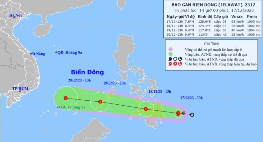
On the afternoon of December 17, the National Center for Hydro-Meteorological Forecasting said a storm with the international name Jelawat is active in the southeastern sea of the southern Philippines.
 |
| Forecast track of storm active in Philippine waters heading towards the East Sea. (Source: NCHMF) |
At 1 p.m., the storm's strongest wind reached level 8 (62-74 km/h), gusting to level 10, moving west at a speed of about 20 km/h.
The meteorological agency said that in the next 24 hours, the storm will maintain its speed and change direction to the west-northwest, then weaken into a tropical depression. This form is likely to enter the East Sea on the afternoon of December 19, then continue to weaken into a low pressure area.
At this time, the directly affected area is located in the southeast of the area between the East Sea and the northeast of the southern East Sea. The wind gradually increases to level 6, gusting to level 8, rough seas with waves 2-3.5m high.
Thus, storm Jelawat is likely to only affect the sea weather for a short time, with little risk of affecting our mainland.
On the same day, the Standing Office of the National Steering Committee for Natural Disaster Prevention and Control sent a telegram to relevant units in coastal provinces and cities from Quang Binh to Kien Giang, requesting close monitoring of the storm's developments.
Units are required to organize the counting and strictly manage vehicles going out to sea, notify owners of vehicles and captains of ships and boats of the location, direction of movement and developments of storms and tropical depressions so that they can proactively avoid, escape or not move into dangerous areas; and prepare forces and means for rescue when required.
On land, the North continues to be under the influence of strong cold air causing widespread severe cold. The place suffering the lowest temperature in the region is Mau Son (Lang Son), when the temperature measured on the morning of December 17 was only 1.2 degrees Celsius.
The meteorological agency warned of the risk of frost and snow in many mountainous areas in the North as temperatures continue to drop tonight.
Notably, heavy rain continued in the area from Quang Tri to Quang Ngai with the amount of 40-80mm, in some places over 120mm. From December 18, heavy rain tended to decrease gradually.
In addition, during the day and night of December 17, Quang Binh and from Binh Dinh to Khanh Hoa will have showers and thunderstorms but the amount will be small, ranging from 15-30mm. Localized heavy rain is likely to occur in some places with rainfall over 60mm.
Source


Comment (0)