
In which, the urban area is developed on the basis of green, identity and happiness, creating motivation, increasing attractiveness and competitiveness, adapting to integration trends, being able to respond to climate change and contributing to improving the quality of life for residents.
Forming a new urban area on the right bank of the Red River

Immediately after leaving the Van Phu intersection of Noi Bai - Lao Cai Expressway on the connecting route to Yen Bai city center, we were surprised by a large-scale urban area project gradually emerging. The project is called Yen Bai Riverside urban area, built on a total area of 23.85 hectares, located on Bach Lam street, Gioi Phien commune, Yen Bai city. Yen Bai Riverside urban area has a total investment of nearly 1,000 billion VND, was granted a construction permit by Yen Bai city People's Committee in March 2024, and is expected to be completed in 2025. This is one of the projects showing the urban shift of Yen Bai city from the left bank to the right bank of the Red River.
 introduce urban projects on the right bank of the Red River that are being implemented.")
The Red River flows through Yen Bai province, stretching from Lang Thip area (Van Yen district) bordering Bao Yen district of Lao Cai province, through Van Yen, Tran Yen districts, Yen Bai city. Due to the characteristics of different elevations, frequent large floods, high flow rates, and high risk of landslides, urban development along the river is very difficult. However, over the decades, with efforts to regulate the river, stable residential areas have been formed and developed into urban areas. In addition to the largest urban area, Yen Bai city, from the North down, you can find Co Phuc, Bao Dap, Mau A, An Thinh towns... According to the plan until 2023, along the Red River, 7 urban areas will be formed, including 1 type II urban area, 2 type IV urban areas, and 4 type V urban areas.
To enhance urban connectivity along the Red River, Yen Bai has invested in building vertical and horizontal routes, connecting Yen Bai's urban areas with each other and with urban areas in the region to take advantage of connecting infrastructure from national traffic axes that have been and are being invested in such as Noi Bai - Lao Cai expressway, Lao Cai - Hanoi - Hai Phong railway, and soon Sa Pa Airport.
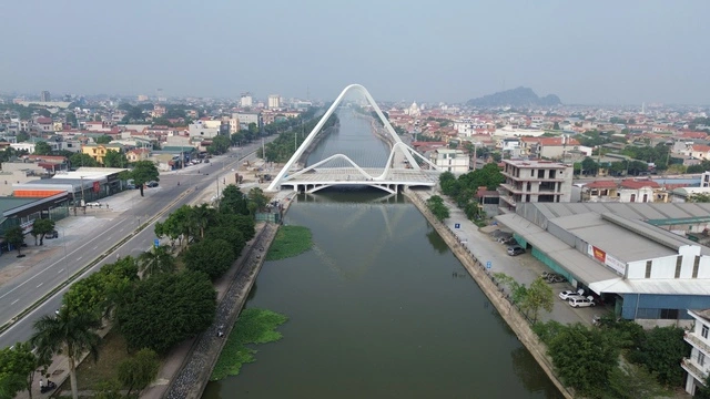
The traffic infrastructure has opened up space for urban development, creating momentum for the formation of new urban areas, attracting people and investors to live, produce, do business, and promote local economic growth. This policy has been shaped by Yen Bai city over the years with key projects and works that have spread to the whole region. Most recently, at the end of 2023, Gioi Phien bridge with a total investment of 650 billion VND across the Red River was officially inaugurated. Along with the existing bridges including Yen Bai bridge, Van Phu bridge, Tuan Quan bridge, Bach Lam bridge, this is also the 5th bridge across the Red River in Yen Bai city, contributing to connecting the two banks, connecting the urban space being planned on the right bank of the Red River with the central urban area, creating a highlight for Yen Bai city.

The leader of the Department of Construction of Yen Bai province said that the new planning project to expand Yen Bai city was approached with a new mindset, creating development space to the right bank of the Red River. At the same time, to build an urban area on both sides of the river, bridges must be built. That is why, as the crow flies from Yen Bai bridge down, it is only more than 7km, but the city has 5 bridges. When the planning project was announced, showing the urban development space along the traffic axes through 3 newly built bridges along with 2 existing bridges before forming 5 urban development axes, it was agreed and supported by the people and businesses. When the State spends 1,000 billion VND to invest in infrastructure, it will attract thousands of billions of VND in private investment capital. Thus, "the urban itself will nurture the urban itself" and the urban itself will create growth, while the state only invests in the framework infrastructure as Prime Minister Pham Minh Chinh often directs, "using public investment to lead and attract private investment".
Spatial orientation on both sides of the Red River
Yen Bai city, initially formed an urban residential area on the riverside, about 40 years ago, the administrative center of Yen Bai province was built into the hill area and formed a new urban center. Today, when the highway as well as many bridges across the Red River have been built, urbanization is expected to be carried out in the area along the Red River.

To be worthy of being the “heart” city of the Northwest region, Yen Bai province has built a plan to reasonably develop the city on both sides of the river, limit the risk of flooding and minimize land development costs; build urban areas associated with the creation of a system of green and public spaces along both sides of the Red River. The advantages of this plan are the formation of public green spaces along the Red River; strengthening the connection between existing and new urban areas on both sides of the Red River; promoting riverside traffic infrastructure; creating the face of the urban area along the Red River, improving the quality of the living environment; exploiting and rationally using the land fund along the Red River.

The orientation of Yen Bai urban space development includes 6 functional zones. In which, the central urban area is the development center of the planning area, including existing urban areas and newly developed urban areas with the Red River axis as the center of dynamic development. The industrial - service area at the Hanoi - Lao Cai expressway intersection is two industrial - service areas closely linked to the IC12, IC13 expressway intersections and the main roads of the urban area, adjacent to the central urban area, here promoting the development of industry, logistics services and trade services, tourism.
The industrial zone is an industrial zone in the southeast of the central urban area, developed on the basis of continued investment in building an industrial zone in the south of Yen Bai city. The Thac Ba lake tourism service urban area is an area that develops diverse types of eco-tourism that promote the nature of Thac Ba lake; develops and expands the urban area in Yen Binh town to become a commercial and logistics service urban area for the Thac Ba lake tourist area. The Van Hoi lake eco-tourism area is an area that develops tourism and high-tech agriculture and forestry in Van Hoi lake and surrounding areas. The agricultural and forestry - rural area is the agricultural and forestry production areas and rural residents located around the urban and industrial areas.
Three main spatial axes form the framework for urban development, including the cultural - tourism axis: The axis from Thac Ba Lake to Van Hoi Lake, passing through the central urban area, connecting tourist areas, new urban areas, trade and service centers, industrial centers with IC12 intersection. Strengthening spatial connectivity and economic activities between existing urban areas, new urban areas along the Red River corridor with this axis.
Historical urban development axis: The urban axis connects the existing urban area with new future development centers and with IC12 and IC13 intersections. A branch from IC13 intersection connects the existing urban centers north of the Red River of Yen Bai city and the service and tourism center in Yen Binh town. A branch connecting from the existing urban area across the Red River via Bach Lam bridge connects with trade and service centers, industrial centers, and new urban areas south of the Red River.

Red River axis - dynamic axis: Is the framework for developing new modern urban areas along the Red River, will become a symbol of outstanding economic development, strong urbanization of Yen Bai city in the future, realizing the urban structure model in the direction of: "Reasonably developing the city on both sides of the Red River, limiting the risk of flooding and minimizing land development costs; building urban areas associated with creating a system of green and public spaces along both sides of the Red River".
Two main traffic axes are identified, including inter-regional traffic axes (highways and national highways connecting the planning area with domestic and foreign economic zones) and urban traffic axes (main urban traffic axes in the belt and radial direction connecting the main urban centers and industrial centers).
Lesson 3: Ecological green belt in Viet Tri
Source: https://baolaocai.vn/bai-2-xay-dung-thanh-pho-ben-song-post399207.html
![[Photo] Unique folk games at Chuong Village Festival](https://vstatic.vietnam.vn/vietnam/resource/IMAGE/2025/4/10/cff805a06fdd443b9474c017f98075a4)
![[Photo] Phuc Tho mulberry season – Sweet fruit from green agriculture](https://vstatic.vietnam.vn/vietnam/resource/IMAGE/2025/4/10/1710a51d63c84a5a92de1b9b4caaf3e5)


![[Photo] Prime Minister Pham Minh Chinh chairs meeting to discuss tax solutions for Vietnam's import and export goods](https://vstatic.vietnam.vn/vietnam/resource/IMAGE/2025/4/10/19b9ed81ca2940b79fb8a0b9ccef539a)


Comment (0)