
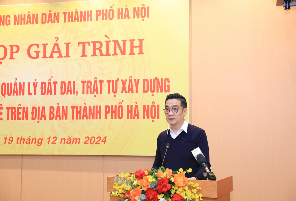
Kinhtedothi - On the morning of December 19, at the explanation session of the Standing Committee of the Hanoi People's Council, Director of the Department of Planning and Architecture (QH-KT) Nguyen Trong Ky Anh reported on planning, land management, and construction order in riverbank areas and outside the dike in the city.
Approval of 9 Master Plans related to the areas on both sides of the Red River and Duong River
Accordingly, the riverbank area, outside the Red River and Duong River dykes passing through Hanoi City, has a total area of about 23,551 hectares, belonging to 17 districts and Son Tay town, involving about 363,987 people. Of which, the Red River route has about more than 339,000 people, including 86,056 households; the Duong River route has 24,585 people, with 6,022 households).
The total length of the Red River dike through Hanoi is 130km (of which the right bank dike is 114.089km long and the left bank dike is 48.781km long). The total length of the Duong River dike through the city is 22km (of which the right bank dike is 21.5km long and the left bank dike is 22.5km long).
In recent times, planning work has continued to be directed resolutely, planning management has had clear changes, basically completing plans after the General Planning for Capital Construction was approved by the Prime Minister with a large volume of general planning projects, zoning plans, sectoral plans and architectural planning management regulations approved, quality has been paid attention to and gradually improved.
Based on the approved Master Plan for the Capital Construction, the guidance of the Ministry of Construction in Official Dispatch No. 17/BXD-KTQH dated April 13, 2012, the City People's Committee has directed the organization to establish and complete the approval of 32/32 master plans for urban areas and master plans for district construction, including 9 master plans for construction of districts, towns, and satellite cities related to the areas on both sides of the Red River and Duong River; with the zoning plan, the approved Master Plan for Son Tay town and Phu Xuyen satellite city has been implemented. The City People's Committee has approved 3/3 urban zoning plans related to the Red River area...
For the area on both sides of the Red River and Duong River in the central urban development area, with the goals and characteristics of the green corridor of the Red River and Duong River stipulated in the Master Plan for the Capital Construction approved by the Prime Minister in 2011, the area has diverse landscape, cultural and historical factors, in the context of the complex existing situation and strict legal regulations, the City People's Committee has directed the Department of Planning and Architecture, the Hanoi Institute of Construction Planning to resolutely organize the establishment, appraisal and the City People's Committee has approved 2 important urban subdivision planning projects: the Red River urban subdivision planning at a scale of 1/5,000 and the Duong River urban subdivision planning at a scale of 1/5,000.

"The projects are unique and complex in nature, and are being implemented for the first time in the city and the whole country. The city has a policy of selecting plans and inviting foreign consultants to implement a number of projects to improve feasibility, access modern technology, preserve traditional values, and develop tourism," said the Director of the Department of Planning and Investment.
Attach responsibility to the head when there is a prolonged violation
Some specific results of the review of wharf areas, according to the Director of the Department of Planning and Investment, currently, along the rivers in the city, there are a total of 188 wharfs, riverside construction material transit areas, of which 42 wharfs have been leased land by the City People's Committee, allocated land to carry out construction material transit activities and Port activities, construction material production (with permission). Currently, 122/188 wharfs are operating and 66/188 wharfs are temporarily suspended.
The work of organizing and implementing the planning has been specifically directed by the City People's Committee, in which the People's Committees of the districts: Dan Phuong, Bac Tu Liem, Tay Ho, Ba Dinh, Hoan Kiem, Hai Ba Trung, Hoang Mai, Thanh Tri, Thuong Tin, Me Linh, Dong Anh, Long Bien, Gia Lam are responsible for drawing the 1/500 scale boundary drawings of existing residential areas that exist, protect... and submit them to the Department of Agriculture and Rural Development for confirmation in accordance with the Flood Prevention and Dike Planning of the Red River and Thai Binh River systems and the agreement of the Ministry of Agriculture and Rural Development, as a basis for land management, investment, construction... in the next phase according to legal regulations.
At the same time, organize the establishment of detailed planning at a scale of 1/500 for existing and protected residential areas; specifically determine the legal status of land use for each plot of land in existing residential areas, as a basis for granting land use right certificates and construction permits according to regulations.

Strictly manage the protection corridor of dykes, riverbanks, and floating areas in accordance with the provisions of the law on dykes, and prevent encroachment and violations, especially after the formation of roads on riverbanks according to the planning. Have solutions to manage existing concentrated residential areas and protect them according to regulations; do not allow the number of areas, areas, and households outside the riverbanks to increase. At the same time, review and develop plans and roadmaps to relocate residential areas in narrow riverbeds, at risk of insecurity during heavy floods (according to the Flood Prevention and Dike Planning Plan) and households violating the law on dykes, located within the dyke protection area, and areas that are experiencing dangerous landslides.
Regarding solutions in the coming time, the City will strengthen the responsibility of State management on planning, land, construction order, environment, and handling of violations of the law on dikes; attach responsibility to the heads in allowing violations to persist but not being handled resolutely and thoroughly. Regularly inspect and review the management and use of riverbank land, mid-bank land, and land within the dike protection corridor to ensure compliance with the law on land, dikes, and related legal regulations; resolutely handle and recover according to authority the area of riverbank land, mid-bank land, and land within the dike protection corridor that is used for the wrong purpose or in violation of the law.
Source: https://kinhtedothi.vn/ha-noi-quan-ly-chat-hanh-lang-bao-ve-de-dieu-dat-bai-song-bai-noi.html


Comment (0)