
On the morning of October 27, at the Government Information and Command Center, the Prime Minister and Deputy Prime Minister Tran Hong Ha held an online meeting with provinces from Ha Tinh to Quang Ngai and Kon Tum province on response to storm No. 6 (storm TRAMI) which will make landfall in the southern Quang Tri-northern Quang Nam provinces at noon on October 27.

According to the latest update report of the National Center for Hydro-Meteorological Forecasting, on the morning of October 27, storm No. 6 is in the sea area of South Quang Tri - Da Nang . The sea area of provinces from Quang Binh to Quang Ngai (including Con Co, Ly Son, and Cu Lao Cham islands) has winds of level 6-7, near the storm center is strong at level 9-10, gusting to level 12. Waves are 2-4 m high, near the storm center are 4-6 m high. The sea is very rough. The coastal areas of Quang Binh-Quang Tri and Quang Ngai-Binh Dinh have waves of 2-4 m high; the Hue-Quang Nam area has waves of 3-5 m high.
It is forecasted that at noon on October 27, storm No. 6 will make landfall in the southern Quang Tri-Da Nang area. The area near the storm will have strong winds of level 8-9, gusting to level 11. The coastal areas of Quang Tri, Thua Thien Hue, and Da Nang will have strong winds of level 8-9, gusting to level 10-11; further inland, there may be strong winds of level 6-7, gusting to level 8-9. The most dangerous time for strong winds is from the morning of October 27 to the afternoon of October 27.

In the next 12-24 hours, the storm will move eastward, move back to the sea, weaken into a tropical depression, then a low pressure area and gradually dissipate.
It is forecasted that from the morning of October 27 to the end of October 29, the Quang Binh-Quang Ngai area will continue to have heavy rain of 200-400 mm, some places over 600 mm. The areas of Southern Nghe An, Ha Tinh; Quang Ngai, Kon Tum will have rain from 150-250 mm, some places over 400 mm. The areas of Northern Nghe An, Gia Lai will have rain from 50-100 mm, some places over 150 mm. The possibility of flooding on rivers from Quang Tri to Quang Ngai is at level BĐ2-BĐ3, rivers in Quang Binh BĐ2, rivers in Ha Tinh, Binh Dinh, Kon Tum BĐ1.
From Quang Binh to Quang Ngai, there are over 30 districts and urban areas with 365 communes at risk of flooding. The risk of flash floods and landslides is high to very high on steep hillsides and talus in the area from South Nghe An to Binh Dinh, Kon Tum and Gia Lai, especially from Quang Binh to Quang Nam.
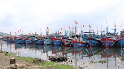
To date, authorities have counted and instructed 67,212 vehicles/307,822 people on the storm's developments and direction; currently no vehicles are in the danger zone.
Dr. Mai Van Khiem, Director of the National Center for Hydro-Meteorological Forecasting, said that with the forecast of storm No. 6 returning to the East Sea, the above storm prevention measures must be given close attention and extended in time.

At the meeting, the Deputy Prime Minister listened to a live report from the Quang Tri Meteorological Station on the developments of wind gusts, rainfall intensity, floods on rivers, the risk of flash floods, landslides, etc. The focus was on heavy rain in the southern region and landslides in the western mountainous region.
Chairman of the People's Committee of Thua Thien Hue province Nguyen Van Phuong said that since 7am this morning, the province has banned people from going out when there is strong wind; maintained police, border guards, and military forces on duty to promptly rescue and relief. Currently, throughout the province, especially in coastal areas, the wind is gradually increasing to level 6-7, the Thuan An estuary area has a high tide of 1.8 m, causing erosion, the province has evacuated 815 households from the affected area.
“With the total forecasted rainfall, all reservoirs in the area are guaranteed to prevent flooding. However, due to prolonged rain, the province will continue to monitor and plan to evacuate about 10,000 households with over 32,000 people from the landslide area,” said Mr. Nguyen Van Phuong.
Deputy Minister of Agriculture and Rural Development Nguyen Hoang Hiep said that reservoirs and hydroelectric lakes in the Central Central region are in the water storage phase, ensuring flood prevention requirements. However, it should be noted that the period of banning ships from operating in the sea area affected by storm No. 6 is longer than before; the risk of landslides is high in mountainous areas due to prolonged heavy rain.

A representative of the Ministry of National Defense said that the military forces and vehicles ready to respond to storm No. 6 are over 275,000 people, more than 6,000 cars, ships, boats, and planes. The Ministry of National Defense has directed Military Region 4, Military Region 5, and units stationed in provinces and cities to coordinate with local authorities to strictly implement proactive measures to respond to storm No. 6 and the storm's floods.
Concluding the meeting, Deputy Prime Minister Tran Hong Ha highly appreciated the preparation work to respond to storm No. 6 in the Central provinces, which was proactive, methodical, and at the highest level.
With the complicated developments of storm No. 6, after making landfall, it will turn out to sea and potentially form a low pressure or a new storm. The Deputy Prime Minister requested that the hydrometeorological system must accurately forecast the time of the storm's landfall and the vulnerable sea dike lines in order to concentrate forces and means to promptly handle incidents. In addition, with heavy and prolonged rainfall, hydrometeorological stations continue to update rainfall and give more specific warnings to people about areas at risk of landslides.
The Ministry of National Defense coordinates and supports localities to urgently deploy a plan to use flycams to inspect, review, and detect large, long-lasting cracks in areas at risk of landslides due to heavy, prolonged rain.
The Ministry of Agriculture and Rural Development, the Ministry of Industry and Trade, and the Ministry of Natural Resources and Environment must have a firm grasp of water flow information at lakes, supplement forecasts from the national hydrometeorological agency, and local hydrometeorological stations to regulate promptly, "not allowing a situation where all lakes have to release water to ensure safety".
The Ministry of Transport, the Ministry of Information and Communications, electricity and telecommunications enterprises closely coordinate with localities to maintain traffic, communication, information connection, and smooth direction and operation.
The Deputy Prime Minister noted that the hydrometeorological agency should closely forecast the time when storm No. 6 will make landfall and then head out to sea. The media should promptly provide full, timely, and accurate information about the complex nature of storm No. 6. Local leaders should continue to pay close attention to the management of vessels at sea.
Source: https://baotainguyenmoitruong.vn/pho-thu-tuong-tran-hong-ha-dua-ra-canh-bao-cu-the-hon-cho-nguoi-dan-ve-khu-vuc-co-nguy-co-xay-ra-sat-lo-382251.html
![[Photo] Ready for the top competitions of Vietnamese table tennis](https://vphoto.vietnam.vn/thumb/1200x675/vietnam/resource/IMAGE/2025/5/18/9c547c497c5a4ade8f98c8e7d44f5a41)

![[Photo] Party and State leaders attend the special art program "You are Ho Chi Minh"](https://vphoto.vietnam.vn/thumb/1200x675/vietnam/resource/IMAGE/2025/5/18/6895913f94fd4c51aa4564ab14c3f250)


![[Photo] Many young people patiently lined up under the hot sun to receive a special supplement from Nhan Dan Newspaper.](https://vphoto.vietnam.vn/thumb/1200x675/vietnam/resource/IMAGE/2025/5/18/6f19d322f9364f0ebb6fbfe9377842d3)


Comment (0)