
Hanoi: Solid constructions continue to spring up in the Soc Son protective forest area. Authorities say it is difficult to handle thoroughly because forest planning overlaps with residential land.
Having lived at the foot of Dong Chum hill (Phu Ninh village, Minh Phu commune) for 35 years, Ms. Nhung has never witnessed a flash flood as violent as that which buried so many cars on August 4.
Ban Tien Hamlet is located at the foot of the hill and was formed in 1988, when the government had a policy of sending people to Soc Son to plant forests. Ms. Nhung said that before, from the hamlet to the top of the hill were green patches, but in recent years, the road up the hill has been concreted. On both sides of the road are solid constructions and plots of land divided into lots and protected by walls.
Recurring violations after two inspections
The road was buried by rocks and soil because households arbitrarily poured concrete, not in the planning, without a construction permit. The records of the People's Committee of Minh Phu commune show that from April 2021 to July 2022, the interdisciplinary force made a record of homestays, houses, and solid structures along the concrete road in the flash flood area in Ban Tien hamlet. The act was determined to be converting protective forest land (planted forest) to non-agricultural land without permission from competent authorities.
About 2 km away, Dong Do irrigation lake (Minh Tan village, Minh Tri commune), where homestays and shops serving tourists are concentrated, is also undergoing a lot of construction activities. At the end of last year, Minh Tri commune issued two notices requesting individuals and organizations related to the illegal land leveling and encroachment of water surface in this area to come to the headquarters to work.
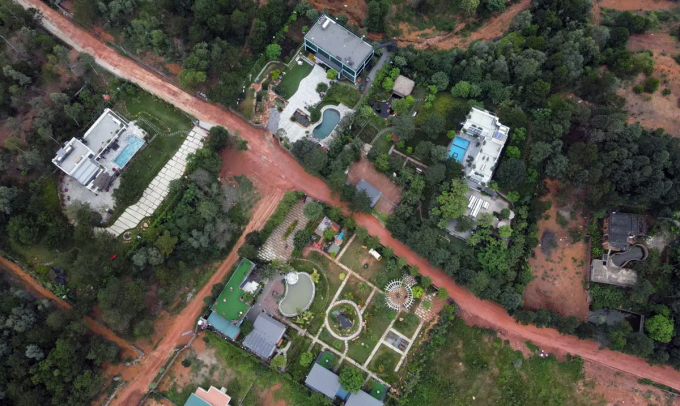
Many solid structures were built at the foot of Dong Chum hill, Ban Tien hamlet. Photo: Hoang Phong
Soc Son protective forest covers an area of 4,557 hectares spread over 10 communes of Soc Son district, including Minh Phu, Minh Tri, Hien Ninh, Bac Son, Nam Son, Hong Ky, Phu Linh, Quang Tien, Tien Duoc, Tan Minh and Soc Son town. The encroachment on Soc Son forest land has been going on for many years.
In 2006, the Government Inspectorate discovered many violations after inspecting the management and use of forest land at Soc Son Forestry and 9 communes. In the protective and special-use forest areas in Soc Son, the authorities counted more than 650 households building structures on forestry land with an area of 11 hectares. Of these, nearly 80 were solid houses and stilt houses; 26 cases were built according to the model of farms and production workshops.
However, the handling and remediation by the People's Committee of Soc Son district and departments and branches is very slow, not thorough and violations continue to occur. Therefore, the city has requested a comprehensive inspection of the management and use of forest land and construction order in Soc Son.
In 2019, the Hanoi Inspectorate announced its conclusion pointing out thousands of violations of protective forest land. In the two communes of Minh Phu, Minh Tri and the areas around large lakes (Dong Quan, Ham Lon, Dong Do...) alone, there were 797 illegal constructions in the forest planning. About 40 district officials were disciplined, and the illegal constructions were forcibly demolished.
A year later, the handling of violations had to be temporarily suspended for review due to complaints from local residents that the 2008 forest planning overlapped with residential areas.
While the authorities are still reviewing, many constructions continue to spring up on land planned for forest. After the flash flood on August 4, the Minh Phu commune authorities made a record of illegal constructions on a concrete road built by the people themselves and five constructions built along the road. Similarly, in the Dong Do lake area, the management agency has discovered and handled many cases of encroachment on water surface area.
According to statistics from Soc Son district, in the first 6 months of this year, authorities discovered 187 cases of violations of construction order on forest land. In addition, the government has handled 149 violating constructions from 2022 and earlier according to the city's inspection decisions and conclusions.
Overlapping planning of forest land and residential land
Minh Tan village, Minh Tri commune is one of the residential areas included in the forest planning in 2008. The village has an area of over 1,115 hectares, of which nearly 700 hectares of forest land are contracted, 290 hectares of orchard land, the rest is land for construction of cultural works, schools, traffic...

Minh Tan villagers look at the 2008 forest planning map on August 11. Photo: Vo Hai
Village chief Nguyen Van Hoa said that in 1985, following the government's policy of greening barren hills, about 100 households from communes in Soc Son district came to Dong Do area to settle down and plant forests. In 2019, when the authorities inspected, the people were shocked to learn that the entire residential area was included in the 2008 forest planning.
"No one came to investigate or ask us anything when we made the plan in 2008. Meanwhile, at that time, people had lived in Dong Do area for more than 20 years with a full grassroots government apparatus such as party secretary, village chief and school system," said Mr. Hoa.
After nearly 40 years, from the initial 100 households, Minh Tan village now has about 200 households. The village chief said that the population is larger, many families have multiple generations but still have to share a household registration because the government has not allowed separation since the planning in 2008.
Also because it is in the forest planning, the road and electricity infrastructure is degraded and not invested in, some households do not have electricity. Repairing and building houses is a violation because it is in the planning, but to ensure living conditions, people still have to build.
According to the People's Committee of Minh Tri commune, because Minh Tan village did not have a cadastral map drawn, in 1998, according to Decision 2334 on approving the planning of special-use protective forest land in Soc Son, this entire area was included in the forest planning.
In 2006, the district established a working group to count the number of households that needed to measure cadastral maps. However, the people of Minh Tan village did not agree with the policy of measuring 400 square meters of residential land and 2,000 square meters of garden and forest land per household, so the district could not implement it. Therefore, in the 2008 decision on the protection forest planning, the entire village was still included in the planning and had not been separated.
"The land management process has had many shortcomings for a long time. The capacity of officials over many terms is limited. Management records are lacking, land records are not kept in full, and households borrowing land in the form of forest registers in the area cannot be identified," the report of the People's Committee of Minh Tri commune stated, pointing out that the situation of buying and selling land in the 2008 forest planning was not monitored. Therefore, only when people registered land and had construction activities did the authorities discover violations.
Mr. Nguyen Manh Phuong, Deputy Director of the Hanoi Department of Agriculture and Rural Development, said that there are about 27,000 hectares of forest in 7 districts and towns (Ba Vi, Chuong My, My Duc, Quoc Oai, Soc Son, Thach That and Son Tay). In early 2022, the Department advised the city to issue a plan to direct forested areas to review, mark, digitize the entire area and assign the agricultural sector to manage.
However, after more than a year, the review has not been completed due to many reasons, including resolving the overlap between forest land and residential land in some areas.

Dong Do irrigation lake, where many constructions violated forest land, was handled by Soc Son district. Photo: Hoang Phong
According to Mr. Phuong, the city has directed Soc Son district to review and prepare complete records of residential land areas of people whose protective forest planning overlapped before 1993. After that, the district needs to coordinate with departments and branches to propose to the City People's Committee to separate the areas of these two types of land.
Vice Chairman of the People's Committee of Soc Son District Pham Quang Ngoc also said that the 2008 forest planning (Decision No. 2100 dated May 29, 2008) had many shortcomings. The city planned the entire 4,557 hectares of land into protective forests while there were only 3,266 hectares of real forests.
"In the remaining 1,300 hectares, there are about 3,000 plots of land belonging to villages, hamlets, and hamlets located in the forest, in addition to welfare projects, historical and cultural relics, and military projects," Mr. Ngoc informed, adding that the district is reviewing to propose to the city to adjust the 2008 forest planning in accordance with reality, expected to be completed in October.
"We hope that people who are in the 2008 planning overlap area will be patient, not build any projects, and wait for the government to review the statistics and have a plan to report to the city," Vice Chairman Soc Son advised.
However, recent statistics show that construction activities are still taking place vigorously in many areas planned for forestation.
Vo Hai


![[Photo] Prime Minister Pham Minh Chinh chairs meeting to discuss tax solutions for Vietnam's import and export goods](https://vstatic.vietnam.vn/vietnam/resource/IMAGE/2025/4/10/19b9ed81ca2940b79fb8a0b9ccef539a)

![[Photo] Phuc Tho mulberry season – Sweet fruit from green agriculture](https://vstatic.vietnam.vn/vietnam/resource/IMAGE/2025/4/10/1710a51d63c84a5a92de1b9b4caaf3e5)
![[Photo] Unique folk games at Chuong Village Festival](https://vstatic.vietnam.vn/vietnam/resource/IMAGE/2025/4/10/cff805a06fdd443b9474c017f98075a4)


Comment (0)