
To proactively respond to storms and heavy rains, the People's Committee of Da Nang City requires heads of armed forces, departments, branches, chairmen of district and commune People's Committees and related units to strictly implement response to storm No. 6.
Accordingly, the chairmen of the People's Committees of districts and towns regularly and closely monitor the developments of storm No. 6 and floods to immediately deploy plans to evacuate people living in boarding houses, temporary houses, non-permanent houses, and areas at risk of landslides, flash floods, and storm surges to safe places.
Localities must complete the evacuation of people before 10:00 p.m. on October 26, with priority given to evacuating high-risk areas due to heavy rain, flooding, flash floods, and landslides.
Da Nang closed the road to Son Tra peninsula from 5:00 p.m. on October 26.
The Chairman of the People's Committee of Da Nang City requested localities to propagate and remind people to limit leaving their homes from 10:00 a.m. on October 27 (except for forces on duty).
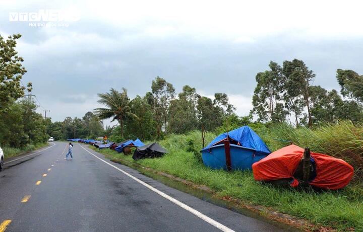
The People's Committees of coastal districts announced and requested that owners of vessels anchor their boats in the designated places and organize towing of small-capacity boats ashore, to be completed before 10:00 a.m. on October 27.
At the same time, the city Border Guard is required to mobilize crew members and fishermen to leave their boats and take safe shelter ashore before 10:00 a.m. on October 27.
Mr. Thai Van Hoai Nam, Chairman of the People's Committee of Hoa Bac Commune, Hoa Vang District, Da Nang City, said that the commune government is making plans and mobilizing forces to evacuate people in areas at risk of landslides and flooding tonight to safe places before storm Trami is expected to make landfall at noon on October 27.
The relocated households include the area along Dinh stream in Nam Yen village, households living at the foot of La Son - Hoa Lien highway (overflow bridge section, near Mui Trau tunnel - hamlet 7 houses) in Ta Lang village and households living close to the mouth of the La Son - Hoa Lien highway underpass, right in the center of Hoa Bac commune.
" We are making plans and will evacuate people tonight according to the direction of the District and City People's Committees ," said Mr. Nam.
According to the National Center for Hydro-Meteorological Forecasting, at 7:00 p.m. on October 26, the eye of the storm was located in the sea northwest of the Hoang Sa archipelago, about 290 km east-northeast of Da Nang. The strongest wind near the eye of the storm was level 11, gusting to level 14. The storm moved at a speed of about 20 km/h.
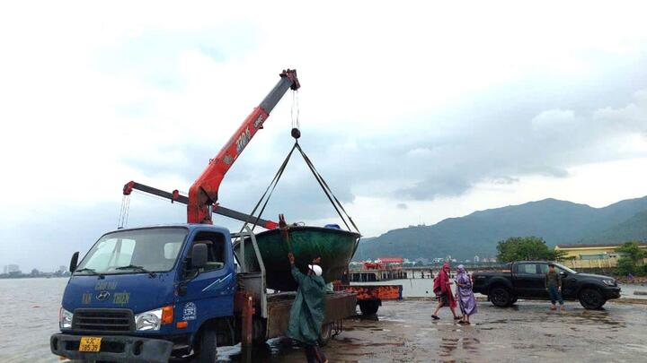
Da Nang fishermen bring their boats ashore to avoid the storm.
It is forecasted that by 7:00 p.m. on October 27, the center of the storm will be at about 15.9 degrees north latitude; 108.1 degrees east longitude, in the area of Quang Tri-Quang Nam provinces, with the strongest wind near the center of the storm at level 8, gusting to level 11. The storm will move in a West-Southwest direction at a speed of about 15km/hour.
At 7:00 p.m. on October 28, the center of the storm was at about 15.3 degrees north latitude; 109.8 degrees east longitude, in the sea off the Central Central Coast, the strongest wind near the center of the storm was level 7, gusting to level 10. The storm moved in a South-Southeast direction then turned East, at a speed of about 5km/hour, weakening into a tropical depression.
According to PV, at 9:00 p.m. on October 26, the weather in Da Nang, Quang Nam, Quang Ngai, Thua Thien-Hue, and Quang Tri had light rain and light winds.
Source: https://vtcnews.vn/bao-trami-cach-bo-290-km-da-nang-di-doi-dan-khan-cap-ar904070.html


Comment (0)