
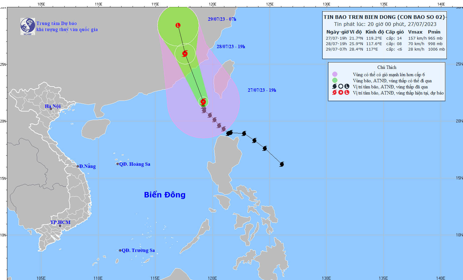
Storm forecast (in the next 24 to 48 hours):
| Forecast time | Direction, speed | Location | Intensity | Danger zone | Disaster Risk Level (Affected Area) |
| 19h/28/7 | North Northwest, about 20 km/h | 25.9N-117.6E | Level 8, level 10 jerk | North of latitude 18.5N; East of longitude 116.0E | Level 3: Northeast area of the North East Sea |
| 7h/29/7 | North Northwest, about 20km/h and gradually weakening | 28.4N-117.0E | North of latitude 22.5N; East of longitude 115.5E | Level 3: Northeast area of the North East Sea |
Forecasting the impact of storms
| Strong wind | |
| At sea: The eastern sea area of the North East Sea has stormy rain, strong winds of level 6-7, the northeastern area has strong winds of level 9-12, the area near the storm center has strong winds of level 13-14, gusts of level 16; the sea is very rough. | |
| Rising water, big waves | |
| In the eastern sea of the North East Sea, waves are 6.0-8.0m high, and near the storm center, waves are 8.0-10.0m high. |
Previously, in the bulletin issued at 4:00 p.m. on July 27, the National Center for Hydro-Meteorological Forecasting said that there would be storms and rain in the eastern sea of the North East Sea, showers and thunderstorms in the central and southern East Sea (including the waters of the Truong Sa archipelago) and the waters from Binh Thuan to Ca Mau. At Phu Quy and Song Tu Tay island stations, there would be strong southwest winds of level 5, sometimes level 6, gusting to level 7-8; Huyen Tran would have strong southwest winds of level 5, sometimes level 6; Truong Sa would have strong southwest winds of level 4-5, gusting to level 7. The eastern sea of the North East Sea would have strong winds of level 6.
In addition, on the night of July 27 and July 28, the eastern sea area of the North East Sea will have storms. The central and southern East Sea area (including the waters of the Truong Sa archipelago), the waters from Binh Thuan to Ca Mau, Ca Mau to Kien Giang and the Gulf of Thailand will have showers and thunderstorms. There is a possibility of tornadoes and strong gusts of wind during thunderstorms.
On the night of July 28, the northeastern sea area of the North East Sea will have southwest winds of level 6, gusting to level 8, with waves 3.0-5.0m high; on the night of July 28 and on July 29, the sea area from Binh Dinh to Ca Mau, the Central and Southern East Sea area (including the sea area of Truong Sa archipelago) will have strong southwest winds of level 6, sometimes level 7, gusting to level 8-9, with rough seas and waves 3.0-5.0m high.
The Hydrometeorological Agency warns that all ships and other activities in the above sea areas are at high risk of being affected by strong winds and large waves.
Source

![[Photo] Prime Minister Pham Minh Chinh chairs conference on anti-smuggling, trade fraud, and counterfeit goods](https://vphoto.vietnam.vn/thumb/1200x675/vietnam/resource/IMAGE/2025/5/14/6cd67667e99e4248b7d4f587fd21e37c)


Comment (0)