Winter Scenery at the World's Longest International Border
Báo Quốc Tế•11/02/2025
The 8,891 km long US-Canada border is one of the longest borders in the world, passing through many famous landmarks such as the Rocky Mountains, Niagara Falls...
Kha Ninh
18:30 | 11/02/2025
The 8,891 km long US-Canada border is one of the longest borders in the world, passing through many famous landmarks such as the Rocky Mountains, Niagara Falls...
The US-Canada border is 8,891 km long, passing through 13 US states and 8 Canadian provinces and 3 territories. In the photo: The Canada-US border in Champlain, New York. (Source: Reuters)
The border between the two countries spans land, sea and pristine wilderness. The route also passes through many famous natural landmarks, such as the Rocky Mountains, the Great Lakes and Niagara Falls, creating stunning landscapes and attracting millions of tourists each year. Pictured: The border between the US state of Vermont and the Canadian province of Quebec. (Source: Reuters)
Vehicles moving on the left side of the yellow line are in Stanstead, Quebec, Canada, and on the right side are in Beebe Plain, Vermont, USA. (Source: Reuters)
Although the border between the two countries is 8,891 km long, much of it is unmanned by military or police. However, at official border crossings, strict controls are maintained to ensure security and traffic management. Many sections of the road are equipped with security cameras. (Source: Reuters)
On the border between Washington state (USA) and British Columbia (Canada), the Peace Arch is a peace arch built in 1921, a symbol of cooperation and peace between the two countries. Tourists from both countries often come here to take souvenir photos. (Source: Reuters)
Along the US-Canada border are stunning natural landscapes. The Rocky Mountains, stretching between British Columbia and Montana, are a popular destination for hikers and nature lovers. Pictured: Cattle graze amid the snow-covered land in southern Alberta, Canada, bordering the US state of Montana. (Source: Reuters)
In addition, the Great Lakes system between Ontario and New York is not only an important source of fresh water but also an ideal place for relaxation and sightseeing. In the photo: Lake Ontario is part of the Great Lakes system. To the north, west and southwest of the lake is the Canadian province of Ontario, to the south and east is the US state of New York with water boundaries in the middle of the lake. (Source: @adventures_in_new_york/Instagram)
Also known as “The Slash,” this 20-foot-wide treeless strip runs through everything between the United States and Canada—from tiny, remote islands to mountains. Unlike the invisible line on maps, “The Slash” is easily recognizable to the naked eye. (Source: Reuters)
The Slash was originally created to help people recognize where they were at the border. Because the US-Canada border is mostly in remote, wooded areas, the markers are scattered, making it easy for people to accidentally cross into another country. The Slash solved this problem by clearing the trees and installing more than 8,000 border markers, although many old markers still exist alongside the current ones. (Source: Reuters)
Unfortunately, in the 1840s there was no GPS system, so the border was marked in a zigzag pattern, about 90 meters north or south of the 49th parallel. (Source: Reuters)
Upkeep of “The Slash” is the responsibility of both countries. Each side is responsible for clearing 3 meters of the border. The US spends about $1.4 million a year on this work, equivalent to 0.5 cents in taxes per person. Every six years, a major pruning is carried out to ensure the border remains clear. (Source: Reuters)
The US-Canada border has many important routes, not only serving for travel but also playing a big role in trade. Pictured: People cross the Rainbow Bridge at the border between Niagara Falls, Ontario, Canada and Niagara Falls, New York, USA. This is also a popular tourist destination, allowing visitors to see the whole view of Niagara Falls from the bridge. (Source: Reuters)
Derby Line, located between Vermont (USA) and Quebec (Canada), is a unique town. The Haskell Free Library and Opera House of this town are located on the border between the two countries. You can step from the US to Canada without going through customs, just by walking through a room. This has turned Derby Line into a unique tourist destination, attracting people who want to experience standing between two countries. In the photo: The border is marked by a black line on the floor. (Source: Reuters)
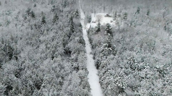
In winter, the border between the two countries is covered in white, creating a beautiful icy scene. (Source: Reuters)
Niagara Falls turned into a wonderland when the water partially froze after a snowstorm. This amazing natural phenomenon attracted many tourists to admire. (Source: Niagara Parks)
Snow covers a house with a stone backyard fence that marks the border between the U.S. state of Vermont and the Canadian province of Quebec. (Source: Reuters)
The sharp "spires" of Flattop Peak are illuminated by the morning sun. Standing out against the snow-covered expanse of Emerald Lake. (Source: Rocky Mountain National Park)


Comment (0)