
The Deputy Minister emphasized that the storm cloud area of the tropical depression/storm is very large and any place in that cloud area can cause thunderstorms, tornadoes, and local heavy rain. Typically, today, the tropical depression/storm is still 400-500km from the shore but Da Nang and Quang Ngai have had very heavy rain. Although the intensity of the tropical depression/storm is not high, disaster prevention agencies cannot be subjective.

According to the National Center for Hydro-Meteorological Forecasting, at 9:00 p.m. tonight, the center of the tropical depression is at 17.0 degrees North latitude; 111.2 degrees East longitude, about 330km East Northeast of Da Nang city. Strongest wind: Level 7 (50-61km/h), gusting to level 9.
Due to the influence of the tropical depression and the strong southwest monsoon, today, in the area from Quang Tri to Quang Ngai, there will be heavy to very heavy rain; in the area from Nghe An to Quang Binh, the South Central Coast, the South Central Highlands and the South, there will be moderate rain, heavy rain and scattered thunderstorms, locally very heavy rain in some places. The rainfall from 7am to 8pm on September 18 was over 200mm in some places such as: Thanh Mai (Nghe An) 225.6mm, Tra My (Quang Nam) 308.6mm, Loc An (Thua Thien Hue) 242.6mm, Huong Tra (Quang Ngai) 242mm, Hoa Bac (Da Nang) 238.2mm...
Regarding the development of the tropical depression, Mr. Nguyen Van Huong, Head of Weather Forecast Department, National Center for Hydro-Meteorological Forecasting, said that in the next 12 hours, the tropical depression is likely to strengthen into a storm with a level 8 intensity, gusting to level 10. The storm's eye is likely to enter the Quang Binh - Quang Tri area.

Regarding strong winds at sea, forecast for tomorrow day and night, September 19: From Nghe An to Quang Ngai (Ly Son, Cu Lao Cham, Con Co, Hon Ngu) there will be strong winds of level 6 - 7, waves 2 - 4m high. The area near the storm center will have winds of level 8, gusts of level 10, waves 3 - 5m high, rough seas.
On land, from early tomorrow morning, the coastal area from Quang Binh to Quang Nam will have strong winds of level 5, with some places reaching level 6, gusting to level 8. From noon and afternoon to tomorrow night, the coastal area from Ha Tinh to Quang Nam will have strong winds of level 6-7, near the storm's eye level 8, gusting to level 10 (focusing on Quang Binh and Quang Tri); deep inland, there will be gusts of level 6-7.
Regarding heavy rain, from tonight to the end of tomorrow night, September 19, the North Central and Central Central provinces are forecast to have rain from 100-300mm, some places over 500mm, causing a very high risk of flooding, flash floods, and landslides. The focus of the rain is the provinces of Quang Tri - Thua Thien Hue - Da Nang, Quang Binh, Ha Tinh. Mr. Huong noted that these localities need to be on guard against heavy rain in a short period of time. Places with less rain are Nghe An, Thanh Hoa, Quang Nam, Quang Ngai with rainfall from 70 - 150mm, some places over 200mm.
Coastal areas from Quang Binh to Quang Ngai (including Ly Son island district, Cu Lao Cham, Con Co) will be affected by a combination of high tides, storm surges and big waves, so there is a risk of flooding in low-lying coastal areas, riverbanks, ship/boat anchorage areas, aquaculture areas and coastal erosion. There is a high possibility of a flood on rivers in the Central region. There is a high risk of flooding in low-lying riverside areas, urban areas, cities and provinces from Nghe An to Quang Nam.
Due to the impact of heavy rain, there is a risk of flash floods and landslides, concentrated in mountainous and midland areas of the Central Central provinces. The Hydrometeorological Agency has compiled statistics and warned of risks in 80 communes and wards with over 200 locations, and sent them to the standing committees of local disaster prevention and control. It is likely that the number of landslide risk locations will increase according to the development of natural disasters in the coming time.


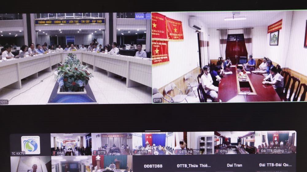
At the meeting, Associate Professor Dr. Pham Thi Thanh Nga, Director of the Institute of Meteorology, Hydrology and Climate Change, said that there were no factors that could cause the storm to be stronger than forecast. However, the worrying thing is that the rain zone could move to the Northern region, which is still dealing with the consequences of the recent storm No. 3.
In addition, leaders of the Department of Water Resources Management and the Hydrographic Center also provided additional information on the situation of reservoirs in the Central region, forecasting and assessing the risk of rising water and waves in coastal areas.
The North Central and Central Central Hydrometeorological Stations shared information about the subjects and areas that may be affected by tropical depressions/storms, and the work of updating forecast information for local disaster prevention and control command committees to proactively deploy response solutions. According to the leader of the National Hydrometeorological Network Center, the network is still operating stably and the Center has prepared for incidents that may occur during the time when tropical depressions/storms affect our country.
Speaking at the meeting, Deputy Minister Le Cong Thanh emphasized that in the past 2 weeks, there have been continuous storms affecting many countries, even super storms in Vietnam, severe flooding in Central Europe... This shows that the impact of climate change in 2024 is extremely severe and widespread, as warned by the World Meteorological Organization. Therefore, Vietnam's Hydrometeorological Agency needs to pay close attention to disaster warning work in the last months of the year.
Regarding the tropical depression that is likely to strengthen into a storm, the Deputy Minister especially noted the need to avoid complacency. The storm is forecast to be at level 8 while previously, the North had to deal with a very strong super typhoon. Forecasting and communication work to disaster prevention agencies and the community needs to look at the broader impacts of heavy rain, thunderstorms, and tornadoes in the storm's circulation cloud area. Heavy rains may occur in the North of the tropical depression and in the South, the Central Highlands when combined with the Southwest monsoon. "You have analyzed this weather situation and the impact will not only be from now until the weekend, but may also be next week" - the Deputy Minister stated clearly and asked the hydrometeorological units to pay close attention to this issue when warning the localities.
In addition, extreme caution is needed because the tropical depression/storm may change direction. Previously, the forecast of the moving trajectory was likely to be complicated, but so far, such complications have not occurred.

The Deputy Minister also requested relevant units to review key reservoirs in areas forecasted for heavy rain. The General Department of Hydrometeorology directed specialized agencies to provide bulletins to localities so that they can proactively inform the public. In particular, it is necessary to specifically warn localities about urban flooding that can cause damage to property and people.
With the influence of the wide cloud range, the Deputy Minister requested the General Department of Hydrometeorology to direct its subordinate units to pay close attention and warn of rain, landslides, flash floods in the Central Highlands and floods in the Mekong River. For many years, the Mekong Delta has only had low floods. This year, the floods are a bit higher but we still have to be on guard against risks.
The Deputy Minister also encouraged the hydrometeorological staff who have made great efforts to monitor storms and floods during the past time and wished them to continue to "stand firm and fight hard", providing timely forecasts and warnings to minimize damage caused by natural disasters.
Source: https://baotainguyenmoitruong.vn/thu-truong-bo-tn-mt-le-cong-thanh-khong-chu-quan-truoc-mua-lon-do-ap-thap-nhet-doi-bao-gay-ra-380260.html

![[Photo] General Secretary To Lam meets with Chairman of the Federation Council, Parliament of the Russian Federation](https://vphoto.vietnam.vn/thumb/1200x675/vietnam/resource/IMAGE/2025/5/10/2c37f1980bdc48c4a04ca24b5f544b33)
![[Video] 24-hour news on May 9, 2025: General Secretary To Lam officially visits the Russian Federation and attends the 80th anniversary of Victory Day in the Great Patriotic War](https://vphoto.vietnam.vn/thumb/1200x675/vietnam/resource/IMAGE/2025/5/10/5eaa6504a96747708f2cb7b1a7471fb9)
![[Photo] Russian military power on display at parade celebrating 80 years of victory over fascism](https://vphoto.vietnam.vn/thumb/1200x675/vietnam/resource/IMAGE/2025/5/9/ce054c3a71b74b1da3be310973aebcfd)

![[Photo] Ho Chi Minh City: Many people release flower lanterns to celebrate Buddha's Birthday](https://vphoto.vietnam.vn/thumb/1200x675/vietnam/resource/IMAGE/2025/5/10/5d57dc648c0f46ffa3b22a3e6e3eac3e)


![[Photo] General Secretary To Lam and international leaders attend the parade celebrating the 80th anniversary of the victory over fascism in Russia](https://vphoto.vietnam.vn/thumb/1200x675/vietnam/resource/IMAGE/2025/5/9/4ec77ed7629a45c79d6e8aa952f20dd3)


Comment (0)