
At 7:00 a.m. on July 18, storm Talim was 100 km from Mong Cai ( Quang Ninh ), with the strongest wind speed of 102 km/h, level 10, expected to make landfall at the Vietnam-China border in 4 hours.
The National Center for Hydro-Meteorological Forecasting said that storm Talim crossed the Leizhou Peninsula (China) at 3:00 a.m. with the strongest wind speed of 117 km/h, level 11, then entered the coast of Guangxi province (China) and continued to weaken.
Pre-storm circulation causes Bach Long Vi Island ( Hai Phong ) to have wind level 7, gusting to level 10; Cua Ong, Co To (Quang Ninh) wind gusting to level 6-7; Phu Lien (Hai Phong) wind gusting to level 6.
The storm is moving west-northwest at a speed of 20 km/h, expected to enter the Vietnam-China border at 11am with the strongest wind speed of 88 km/h, level 9. By 4pm, the storm's center is in the northeast of the North, the wind has decreased to level 7 and weakened into a tropical depression. The tropical depression then continues to move deeper into the northern mountainous region and dissipates early on July 19.
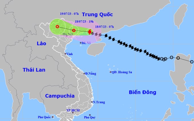
Forecast of the storm's path and affected area at 7:00 a.m. on July 18. Photo: NCHMF
Compared to yesterday afternoon's forecast, the direction and intensity of storm Talim have changed slightly. The storm's center has passed Mong Cai City (Quang Ninh), so the scope of rain has narrowed. The Northeast and Viet Bac will have 200-300 mm of rain, with some areas having over 350 mm. The Northwest, the Northern Delta, Thanh Hoa and Nghe An will have 70-150 mm of rain.
The Japan Meteorological Station forecasts that the storm will make landfall on the Vietnam-China border but will tilt north, with winds still exceeding 70 km/h when it moves inland. The Hong Kong Meteorological Station also forecasts a similar direction, with a wind speed of 105 km/h before making landfall, and the storm will weaken into a low pressure area in Bac Kan province.
Gulf of Tonkin waves are 2-3.5 m high. Coastal areas of Quang Ninh - Hai Phong provinces have waves 1.5-2 m high. Risk of flooding in low-lying coastal areas, river mouths, and coastal erosion due to the combined impact of high tides, big waves, and storm surges (0.3-0.5 m) on the afternoon of July 18.
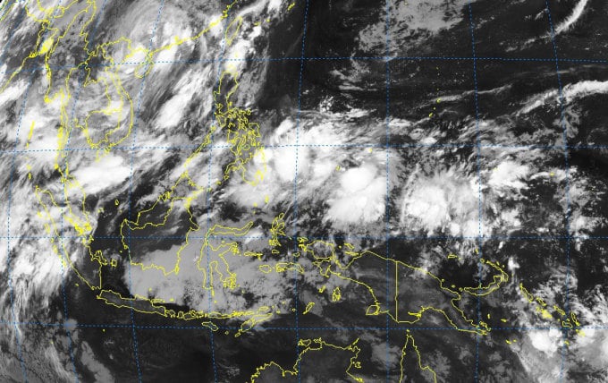
Satellite image of convergence zone over the Northwest Pacific Ocean on the morning of July 18. Photo: NCHMF
Today, three airports directly and indirectly affected by storm Talim, Van Don (Quang Ninh), Cat Bi (Hai Phong) and Noi Bai (Hanoi), have closed. The call for boats and evacuation of people in coastal provinces from Quang Ninh to Thai Binh has been basically completed. Localities are on standby, taking precautions against rain after the storm that could cause flooding, landslides, and affect key dikes.
Typhoon Talim formed on the tropical convergence zone in the Northwest Pacific Ocean. After entering the East Sea, it mainly moved in a west-northwest direction, quickly strengthening, reaching a maximum speed of 133 km/h (level 12) on July 17. After Talim, there is a possibility of 2-3 storms forming from this convergence zone, one of which will enter the East Sea in the next 4-6 days.
Source link

![[Photo] Party and State leaders attend the special art program "You are Ho Chi Minh"](https://vphoto.vietnam.vn/thumb/1200x675/vietnam/resource/IMAGE/2025/5/18/6895913f94fd4c51aa4564ab14c3f250)
![[Photo] Many young people patiently lined up under the hot sun to receive a special supplement from Nhan Dan Newspaper.](https://vphoto.vietnam.vn/thumb/1200x675/vietnam/resource/IMAGE/2025/5/18/6f19d322f9364f0ebb6fbfe9377842d3)


![[Photo] Ready for the top competitions of Vietnamese table tennis](https://vphoto.vietnam.vn/thumb/1200x675/vietnam/resource/IMAGE/2025/5/18/9c547c497c5a4ade8f98c8e7d44f5a41)


Comment (0)