
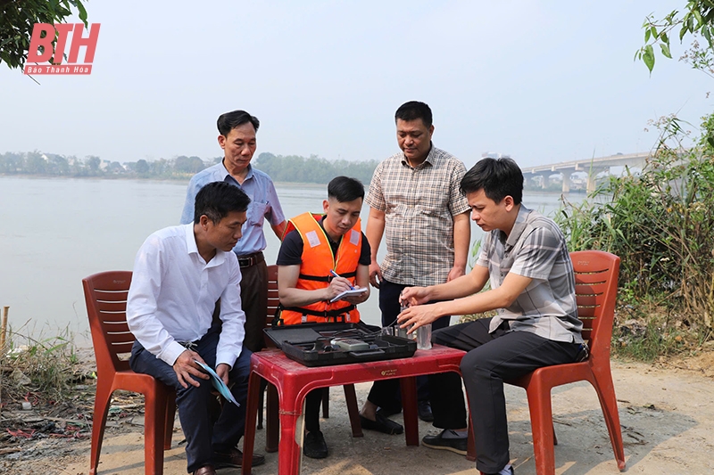
Conducting the first tide - salinity measurement in 2025 at Nguyet Vien station (Thanh Hoa city).
Deputy Head of the Irrigation Sub-Department, Department of Agriculture and Rural Development Le Hung Cuong said: According to Plan No. 02/KH-STNMT of the Department of Natural Resources and Environment, now the Department of Agriculture and Rural Development, the tide-salinity measurement activities on the Ma River, Yen River and Bang River systems in 2025 will be carried out in 2 phases. Phase 1 will be monitored at 16 stations such as Giang, Ham Rong, Nguyet Vien, Quang Chau stations on the Ma River; Ngoc Ha, Quang Phuc, Ben Mam stations on the main stream of Yen River; Khoa Truong, Xuan Lam stations on the Bang River system... The monitoring period is from March 10 to March 29, 2025. Phase 2 will be monitored at 6 stations on the Ma River system (De Canal, Lach Truong River) including Cau De, Nam Huan, Cau Tao, Cu Da, Van Ninh stations and Hoang Ha station. The monitoring period is from March 30 to April 8, 2025.
Up to now, the functional unit of the Department of Agriculture and Environment has completed the first phase of monitoring according to the plan. According to the report on the results of measuring the salinity intrusion situation of the Thanh Hoa Mining and Geology Group from March 20 to March 24, the salinity intrusion level on the Ma River, Bang River, and Yen River systems fluctuated at a level lower than the average of many years and the same period in 2024.
For example, on the main stream of the Ma River, in Quang Chau ward (Sam Son city), the highest salinity at the peak of the tide ranges from 19.20 - 22.14%o; the lowest salinity at the foot of the tide ranges from 0.90 - 0.92%o. At Nguyet Vien bridge area, Hoang Dai commune (Thanh Hoa city), the highest salinity at the peak of the tide ranges from 8.62 - 12.03%o; the salinity at the foot of the tide ranges from 0.14 - 0.28%o. At Giang area, Thieu Khanh ward (Thanh Hoa city), the highest salinity at the peak of the tide ranges from 0.98 - 1.55%o; the salinity at the foot of the tide ranges from 0.01 - 0.03%o. The salinity of 1%o is 24.5km from the estuary (Thieu Khanh ward, Thanh Hoa city).
On the Len River, observations and investigations at Lach Sung, Da Lau commune (Hau Loc) showed that the maximum salinity at the peak of the tide ranged from 20.34 - 22.57%o; the minimum salinity at the foot of the tide ranged from 0.77 - 3.20%o. At Pha Tham, Lien Loc commune (Hau Loc), the salinity at the peak of the tide ranged from 5.10 - 7.92%o; the salinity at the foot of the tide ranged from 0.13 - 0.21%o. At Cu Thon, Linh Toai commune (Ha Trung), the salinity at the peak of the tide ranged from 0.19 - 0.38%o; the salinity at the foot of the tide ranged from 0.03 - 0.05%o. The salinity from the estuary to 18.3km (Linh Toai commune, Ha Trung district) was 1%o.
On the Yen River, at Ngoc Tra station, Quang Trung commune (Quang Xuong), the peak salinity ranges from 7.49 - 9.21%o; the salinity at the foot of the tide ranges from 0.57 - 1.29%o. At Ben Mam, Minh Khoi commune (Nong Cong), the peak salinity ranges from 0.06 - 0.08%o; the salinity at the foot of the tide ranges from 0.02 - 0.03%o. Salinity of 1%o can penetrate 18.8km into the river mouth in Quang Phuc commune (Quang Xuong). On the Nhon River, salinity of 1%o can penetrate 21.8km into the river mouth in Te Nong commune (Nong Cong). On the Bang River from Xuan Lam Ward to Tung Lam Commune (Nghi Son), the level of salinity intrusion at Cau Dua and Khoa Truong stations fluctuates at a lower level than the average of many years and the same period in 2024. However, a salinity of 1%o has penetrated the entire river...
Based on the results of the investigation as well as the assessment of the current situation of tides and salinity on the rivers, the Department of Agriculture and Environment has issued a document to districts, towns and cities as a basis for planning appropriate exploitation and use of water resources. According to the Deputy Head of the Department of Irrigation, Department of Agriculture and Environment, Le Hung Cuong, from the results of the investigation and monitoring, people can determine the ability to exploit and use water resources in tidal areas in the province effectively. This is also an important basis for the functional sector to propose solutions to improve the efficiency of water resource use. In particular, through the results of the investigation, it is recommended that localities in tidal river areas need to have plans to convert crops and livestock to adapt to climate change and salinity intrusion; use water economically and reasonably in production and daily life...
Article and photos: Phong Sac
Source: https://baothanhhoa.vn/danh-gia-dien-bien-trieu-man-phuc-vu-san-xuat-va-dan-sinh-244049.htm
![[Photo] Close-up of Vietnam's sniffer dog team searching for earthquake victims in Myanmar](https://vstatic.vietnam.vn/vietnam/resource/IMAGE/2025/4/1/d4949a0510ba40af93a15359b5450df2)
![[Photo] Prime Minister Pham Minh Chinh meets with King Philippe of Belgium](https://vstatic.vietnam.vn/vietnam/resource/IMAGE/2025/4/1/be2f9ad3b17843b9b8f8dee6f2d227e7)


![[Photo] President Luong Cuong and King Philippe of Belgium visit Thang Long Imperial Citadel](https://vstatic.vietnam.vn/vietnam/resource/IMAGE/2025/4/1/cb080a6652f84a1291edc3d2ee50f631)
![[Photo] General Secretary To Lam receives King Philippe of Belgium](https://vstatic.vietnam.vn/vietnam/resource/IMAGE/2025/4/1/e5963137a0c9428dabb93bdb34b86d7c)


![[6pm News] Of the 40 newly discovered gold mines, 4 are in Thanh Hoa](https://vstatic.vietnam.vn/vietnam/resource/IMAGE/2025/4/1/08644991aa1b4030a549159f2f87c0d6)


![[Photo] Myanmar's capital in disarray after the great earthquake](https://vstatic.vietnam.vn/vietnam/resource/IMAGE/2025/4/1/7719e43b61ba40f3ac17f5c3c1f03720)


Comment (0)