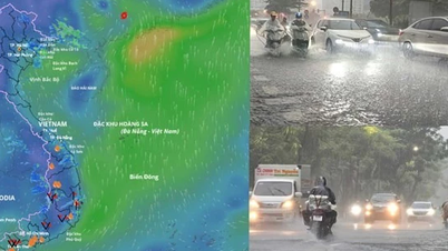
Latest storm number 7 news, according to the National Center for Hydro-Meteorological Forecasting, storm number 7 - storm Yinxing is about 480km northeast of Hoang Sa archipelago. The strongest wind near the storm center is level 14 (150-166km/h), gusting to level 17.
Update on storm number 7: 480km from Hoang Sa archipelago, level 14, gust level 17
Latest news on storm No. 7, according to the National Center for Hydro-Meteorological Forecasting, at 4:00 a.m. (November 9), the center of storm No. 7 was at about 18.7 degrees North latitude; 115.5 degrees East longitude, in the eastern sea of the North East Sea, about 480km northeast of Hoang Sa archipelago.
The strongest wind near the storm center is level 14 (150-166km/h), gusting to level 17. Moving in the West Northwest direction, speed about 15km/h.
By 4am on November 10, storm No. 7 will be in the North East Sea, about 340km northeast of Hoang Sa archipelago, reaching level 13, gusting to level 16.
At 4:00 a.m. on November 11, storm No. 7 was about 200km northwest of Hoang Sa archipelago, reaching level 11, gusting to level 14; at 4:00 a.m. on November 12, storm No. 7 in the Quang Tri- Quang Ngai sea area weakened into a tropical depression.
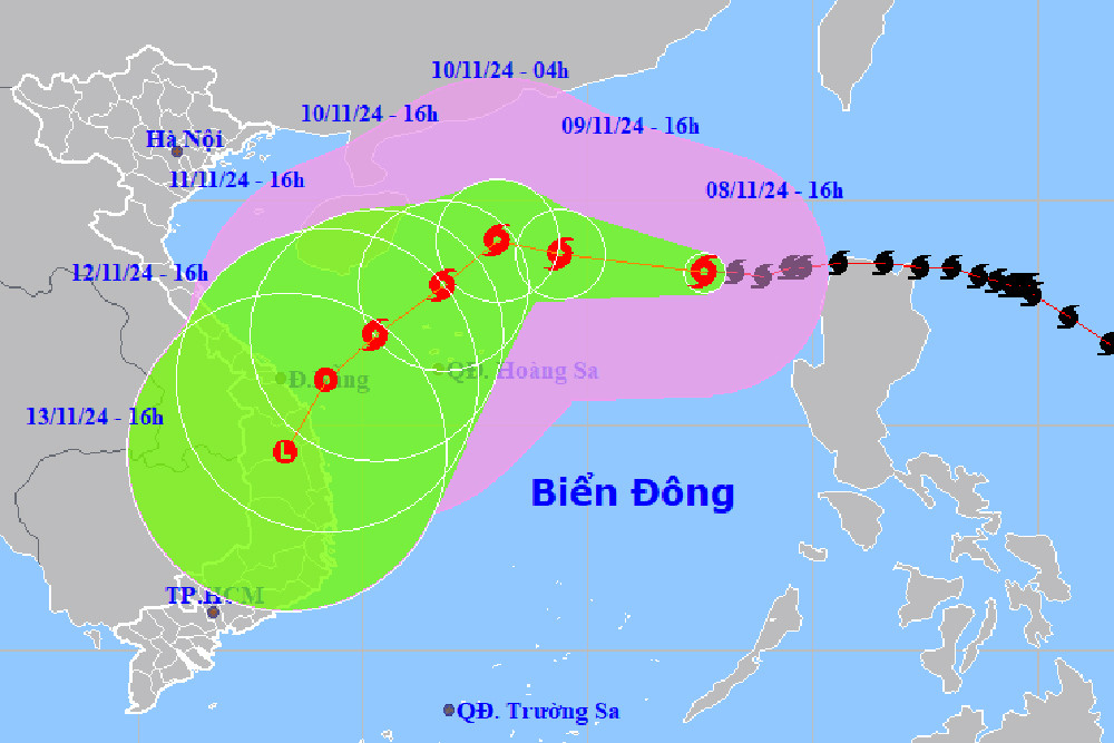
The movement of storm No. 7. Photo: nchmf.
Detailed forecast of storm No. 7 ( in the next 24 to 72 hours)
| Forecast time | Direction, speed | Location | Intensity | Danger zone | Disaster Risk Level (Affected Area) |
| 04h/10/11 | West Northwest, about 15km/h | 19.3N-112.3E; in the North East Sea area, about 340km northeast of Hoang Sa archipelago | Level 13, level 16 | Latitude 16.5N-21.0N; East of longitude 110.0E | Level 3: North East Sea area (including Hoang Sa archipelago waters) |
| 04:00/11/11 | Southwest, about 10-15km/h, weakening | 17.8N-110.8E; about 200km northwest of Hoang Sa archipelago | Level 11, level 14 | Latitude 16.0N-21.0N; longitude 109.0E-115.0E | Level 3: West of the North East Sea area (including the waters of the Hoang Sa archipelago) |
| 04h/12/11 | Southwest approximately 10km/h and gradually weaken into a tropical depression | 16.1N-109.3E; on the sea of Quang Tri - Quang Ngai | Level 6-7, level 9 jerk | Latitude 14.5N-19.0N; West of longitude 114.0E | Level 3: West of the North East Sea area (including the Hoang Sa archipelago waters); Quang Tri-Quang Ngai waters |
Warning of tropical depression developments ( from next 72 to 96 hours):
From the next 72 to 96 hours, the tropical depression will move in the southwest direction, about 10km per hour, and its intensity will continue to weaken.
Warning of the impact of storm No. 7
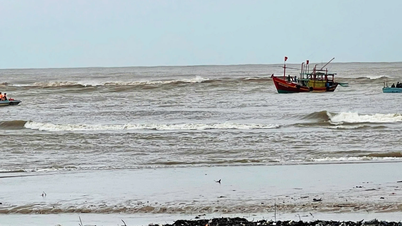
In the North East Sea, strong winds level 8-11, near the storm center level 12-14, gusts level 17, waves 4.0-6.0m high, near the center 7.0-9.0m; rough seas.
Vessels operating in the above mentioned dangerous areas are susceptible to the impact of storms, whirlwinds, strong winds and large waves.
 ") // // .removeAttr("style"); el.find(".first").show(); el.find("a.second").html(""); el.find("a.second").removeAttr("data-out"); $('.comment-account').html(`
 ") // // .removeAttr("style"); el.find(".first").show(); el.find("a.second").html(""); el.find("a.second").attr("data-out", "0"); $('.comment-account').html(` ") // .removeAttr("style"); //el.find("a.second").html(""); }); }; fnPopupBindAction(); //login Facebook var otherLogin = { init: function() { var me = this; //gapi.load('auth2', function () { // gapi.auth2.init({ // client_id: '678720187862-08lendtdt5h3nr4j2he534p15b13aieg.apps.googleusercontent.com', // scope: 'email profile', // fetch_basic_profile: true // }); //}); $("#cmt-account-social button[data-type]").on('click', function() { me[$(this).attr("data-type")](function(response) { $("#cmt-account-header .tabs .close, #cmt-account .tabs .close") .click(); }); }); try { fbClient.appId = '1304555827613749'; //'211029740744825'; fbClient.version = "v14.0"; fbClient.init(); setTimeout(FB.AppEvents.logPageView, 5000); } catch (e) { // ignore } }, loginFacebook: function(cb) { var me = this; function reloginFacebook(callback) { FB.api('/me', { fields: 'id, name, email' }, function(profile) { //console.debug(profile); if (typeof callback === "function") callback(profile); }); }; FB.login(function(response) { if (response.authResponse) { reloginFacebook(function(info) { console.log(info); info.social = "facebook"; info.accessToken = response.authResponse.accessToken; var user = { email: info.email, name: info.name, } let now = new Date(); lgSetCookie('my_dv',JSON.stringify(user), new Date(now.getTime() + (30 * 12 * 60000))); authLogin(user.name, true); }); } else { $("#cmt_alert").html( "You have denied permission to access your Facebook account"); } }, { scope: 'public_profile,email' }); }, loginGoogle: function(callback) { var me = this; function callSocialApi(data, cb) { data.social = "google"; var user = { email: data.email, name: data.name, } let now = new Date(); lgSetCookie('my_dv',JSON.stringify(user), new Date(now.getTime() + (30 * 12 * 60000))); authLogin(user.name, true); } // API call for Google login if (gapi.auth2.getAuthInstance().isSignedIn.get()) { //console.debug('[VCC] GAPI Process'); var profile = gapi.auth2.getAuthInstance().currentUser.get().getBasicProfile(); //var id_token = gapi.auth2.getAuthInstance().currentUser.get().getAuthResponse().id_token; var access_token = gapi.auth2.getAuthInstance().currentUser.get().getAuthResponse() .access_token; var params = { id: profile.getId(), name: profile.getName(), email: profile.getEmail(), accessToken: access_token } //console.log('params: ', params); callSocialApi(params, callback); } else { //console.debug('[VCC] GAPI Login'); gapi.auth2.getAuthInstance().signIn().then( function(success) { var profile = gapi.auth2.getAuthInstance().currentUser.get() .getBasicProfile(); //var id_token = gapi.auth2.getAuthInstance().currentUser.get().getAuthResponse().id_token; var access_token = gapi.auth2.getAuthInstance().currentUser.get() .getAuthResponse().access_token; var params = { id: profile.getId(), name: profile.getName(), email: profile.getEmail(), accessToken: access_token } //console.log('params: ', params); callSocialApi(params, callback); }, function(error) { $("#cmt_alert").html( "You have refused to grant Dan Viet Newspaper permission to access your Google account" ); } ); } } } otherLogin.init(); });
Source: https://danviet.vn/tin-bao-so-7-moi-nhat-cach-hoang-sa-480km-huong-thang-quang-tri-quang-ngai-bao-gio-vao-dat-lien-20241109051633069.htm

![[Photo] The road connecting Dong Nai with Ho Chi Minh City is still unfinished after 5 years of construction.](https://vphoto.vietnam.vn/thumb/1200x675/vietnam/resource/IMAGE/2025/11/04/1762241675985_ndo_br_dji-20251104104418-0635-d-resize-1295-jpg.webp)
![[Photo] Ho Chi Minh City Youth Take Action for a Cleaner Environment](https://vphoto.vietnam.vn/thumb/1200x675/vietnam/resource/IMAGE/2025/11/04/1762233574890_550816358-1108586934787014-6430522970717297480-n-1-jpg.webp)

![[Photo] Panorama of the Patriotic Emulation Congress of Nhan Dan Newspaper for the period 2025-2030](https://vphoto.vietnam.vn/thumb/1200x675/vietnam/resource/IMAGE/2025/11/04/1762252775462_ndo_br_dhthiduayeuncbaond-6125-jpg.webp)
![[Photo] Ca Mau "struggling" to cope with the highest tide of the year, forecast to exceed alert level 3](https://vphoto.vietnam.vn/thumb/1200x675/vietnam/resource/IMAGE/2025/11/04/1762235371445_ndo_br_trieu-cuong-2-6486-jpg.webp)