
Storm No. 7 Yinxing has weakened into a tropical depression, causing heavy rains in the Central and Central Highlands provinces. At the same time, the East Sea welcomed storm No. 8, gusting to level 12 this morning, but is forecast to dissipate at sea.
According to the National Center for Hydro-Meteorological Forecasting, due to the influence of the tropical depression (weakened from storm No. 7 ) last night and this morning (November 12), the area from Thua Thien Hue to Quang Ngai had moderate rain, heavy rain, and in some places very heavy rain, with total rainfall ranging from 30-70mm, locally over 100mm. On Ly Son Island (Quang Ngai), there were strong winds of level 6, gusting to level 8.
At 7am this morning, the center of the tropical depression was over the sea of Quang Nam - Binh Dinh. The strongest wind near the center of the tropical depression was level 6 (39-49km/h), gusting to level 8. Moving southwest at a speed of 15-20km/h.
In the next 12 hours, the tropical depression will maintain its direction of movement, at a speed of about 15km/h, and then weaken into a low pressure area over the coastal areas of Quang Ngai - Phu Yen provinces.
Due to the influence of the above patterns, the weather in the sea area from Thua Thien Hue to Phu Yen (including Ly Son island district) today has strong winds of level 6, gusts of level 9, waves 2-3m high; rough seas.
Today and tonight, the area from Thua Thien Hue to Phu Yen will have moderate rain, heavy rain, locally very heavy rain and thunderstorms with rainfall from 40-100mm, locally over 200mm. Warning of the risk of local heavy rain (>100mm/6 hours).
The Central Highlands region has moderate to heavy rain, locally very heavy rain and thunderstorms with rainfall from 30-60mm, locally over 150mm. From November 13, heavy rain will gradually decrease. From the night of November 13, heavy rain will end in the Central region and the Central Highlands. During thunderstorms, there is a possibility of tornadoes, lightning and strong gusts of wind.
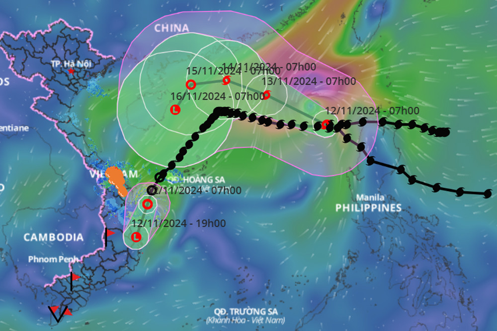
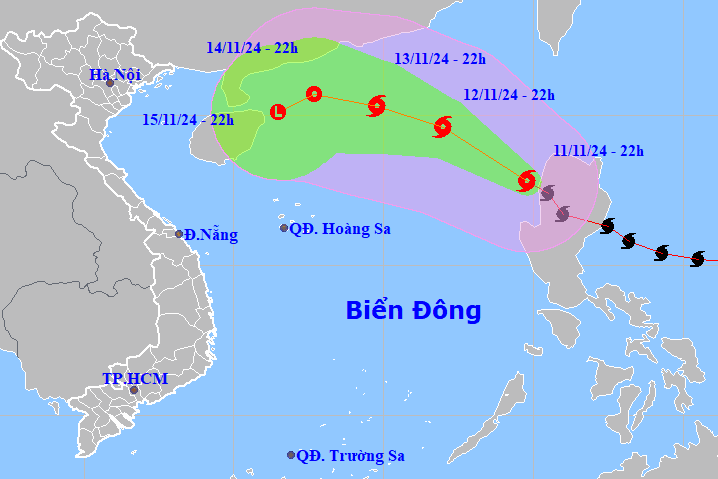
In another development, last night, Typhoon Toraji entered the East Sea, becoming the 8th typhoon of 2024. At 7:00 a.m. this morning, the eye of the storm was located in the eastern sea of the North East Sea. The strongest wind near the eye of the storm was level 9-10 (75-102 km/h), gusting to level 12. Moving northwest at a speed of about 10 km/h.
24 hours later, storm No. 8 maintained its direction of movement and intensity, with a speed increase to 15km/h; still in the eastern sea area of the North East Sea.
In the next 24 to 48 hours, the storm will move west-northwest and then west-southwest at a speed of 10-15km/h, gradually weakening in intensity. At 7am on November 15, storm No. 8 weakened into a tropical depression in the northwest of the North East Sea.
From the next 72 to 96 hours, the tropical depression will move in the West Southwest direction, about 5km per hour, and its intensity will continue to weaken.
Due to the influence of storm No. 8, the eastern sea area of the North East Sea has strong winds of level 6, then increasing to level 7-8, the area near the storm's eye has levels 9-10, gusts of level 12, waves 3-5m high, the area near the storm's eye has 5-7m; the sea is very rough.
Ships operating in the above mentioned dangerous areas are susceptible to the effects of storms, whirlwinds, strong winds and large waves.
In addition, according to meteorological experts, the East Sea may welcome storm No. 9 in the near future, as there is a tropical depression and an active storm off the coast of the Philippines.
Deputy Director General of the General Department of Hydrometeorology Hoang Duc Cuong suggested that the National Center for Hydrometeorological Forecasting, together with the Institute of Meteorology, Hydrology and Climate Change, continue to conduct research to obtain more information on the interaction between weather systems. Along with strong winds caused by storms, it is necessary to pay attention to the situation of the Northeast monsoon to make timely forecasts, because in some cases, the monsoon can be stronger than storm winds.
Storm Toraji becomes storm number 8, likely to dissipate immediately in the East Sea

Weather forecast for the next 10 days: Sunny in the North, heavy rain in the Central region
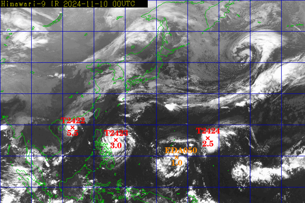
Series of 3 storms and tropical depressions, possibility of storm number 9
Source: https://vietnamnet.vn/vung-ap-thap-tan-tren-bien-quang-ngai-phu-yen-bao-so-8-giat-cap-12-2341095.html
![[Photo] Prime Minister Pham Minh Chinh and Prime Minister of the Kingdom of Thailand Paetongtarn Shinawatra attend the Vietnam-Thailand Business Forum 2025](https://vphoto.vietnam.vn/thumb/1200x675/vietnam/resource/IMAGE/2025/5/16/1cdfce54d25c48a68ae6fb9204f2171a)


![[Photo] President Luong Cuong receives Prime Minister of the Kingdom of Thailand Paetongtarn Shinawatra](https://vphoto.vietnam.vn/thumb/1200x675/vietnam/resource/IMAGE/2025/5/16/52c73b27198a4e12bd6a903d1c218846)


Comment (0)