
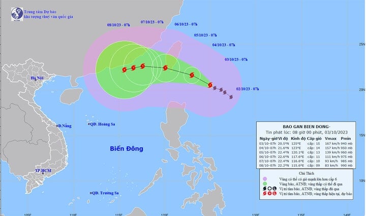
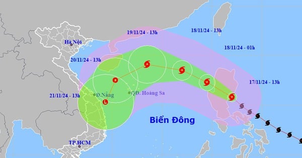
The National Center for Hydro-Meteorological Forecasting said that currently (October 3), a very strong storm with the international name Koinu is active in the sea northeast of Luzon Island (Philippines).
At 7:00 a.m. on October 3, typhoon Koinu was in the sea northeast of Luzon Island, the strongest wind near the storm center was level 15 (167-183 km/h), gusting over level 17. The storm was moving northwest at a speed of about 10 km/h.
Forecast path of typhoon Koinu.
Forecast by 7am on October 4, the storm will change direction, moving West Northwest, about 10km/h per hour. The strongest wind near the storm center is level 14-15, gusting over level 17. Affected area: Southeast Taiwan (China).
At around 7am on October 5, the storm did not change direction, with a speed of about 10km/h. The strongest wind near the storm center was level 13, gusting to level 16. Affected area: Northeast of the North East Sea.
At 7:00 a.m. on October 6, typhoon Koinu moved westward, traveling about 10km per hour. The strongest wind near the storm center was level 11, gusting to level 13. Affected area: Northeast of the North East Sea
From the next 72 to 120 hours, the storm will move mainly in a westerly direction, about 5-10 km per hour, and its intensity will continue to weaken.
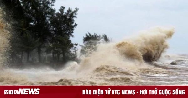
Impact of typhoon Koinu, the northeastern sea of the North East Sea from the night of October 3rd, the wind gradually increased to level 6-7, from the night of October 4th, it increased to level 8-10, the area near the storm center level 11-13, gusting to level 16, the sea was very rough. Waves were 2-4 m high, from the night of October 4th, waves were 5-7 m high.
Nguyen Hue
Source


![[Photo] Ho Chi Minh City welcomes a sudden increase in tourists](https://vstatic.vietnam.vn/vietnam/resource/IMAGE/2025/4/25/dd8c289579e64fccb12c1a50b1f59971)


![[Photo] President Luong Cuong meets with Lao National Assembly Chairman Xaysomphone Phomvihane](https://vstatic.vietnam.vn/vietnam/resource/IMAGE/2025/4/25/dd9d8c5c3a1640adbc4022e2652c3401)
![[Photo] Liberation of Truong Sa archipelago - A strategic feat in liberating the South and unifying the country](https://vstatic.vietnam.vn/vietnam/resource/IMAGE/2025/4/25/d5d3f0607a6a4156807161f0f7f92362)


Comment (0)