
Latest storm news: Experts say that in the coming days, storms No. 8 and No. 9 may appear in the East Sea.
Latest storm news
Due to the influence of storm No. 7, Ly Son Island ( Quang Ngai ) has strong winds of level 6, gusting to level 7. Tonight (November 11), after moving into the western sea area of Hoang Sa archipelago, storm No. 7 has weakened into a tropical depression.
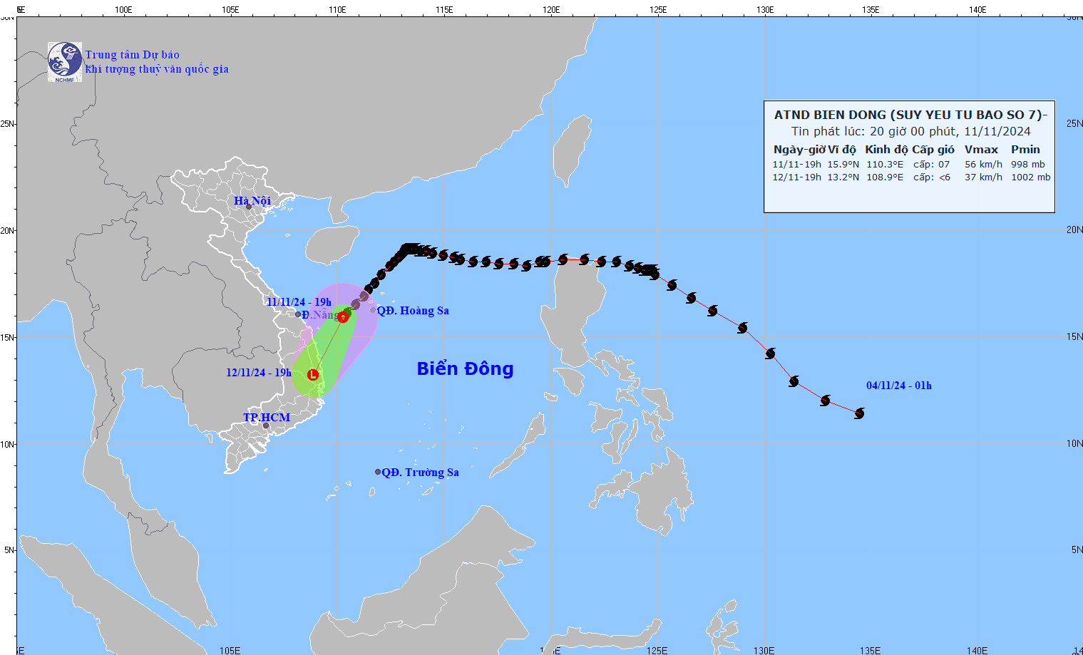
Tonight (November 11), after moving into the western sea area of the Hoang Sa archipelago, storm No. 7 weakened into a tropical depression. Photo: NCHMF
At 7 p.m., the center of the tropical depression was at about 15.9 degrees North latitude; 110.3 degrees East longitude, in the sea west of Hoang Sa archipelago. The strongest wind near the center of the tropical depression was level 7 (50-61 km/h), gusting to level 9. Moving southwest at a speed of 15-20 km/h.
Tropical depression development ( in the next 12 to 24 hours)
Forecast time | Direction, speed | Location | Intensity | Danger zone | Disaster Risk Level (Affected Area) |
19h/12/11 | Southwest, about 15km/h, weakening into a low pressure area | 13.2N-108.9E; on land in Quang Ngai- Phu Yen provinces | Latitude 14.0N-18.0N; longitude 109.0E-112.5E | Level 3: Hoang Sa archipelago waters, offshore waters from Thua Thien Hue to Binh Dinh |
Impact of tropical depression
The sea area of Hoang Sa archipelago has strong winds of level 6-7, waves 2.0-4.0m high; rough seas.
The sea area off Thua Thien Hue to Binh Dinh (including the sea area of Ly Son island district) has strong winds of level 6-7, gusts of level 9, waves 2.0-4.0m high; rough seas.
Ships operating in the above mentioned dangerous areas are likely to be affected by storms, whirlwinds, strong winds and large waves.
Latest updates on the location and path of Typhoon Toraji
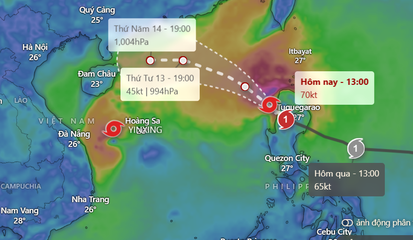
At 7:00 p.m. on November 11, the center of the storm was at approximately 17.4 degrees North latitude; 120.5 degrees East longitude, on the west coast of Luzon Island (Philippines). The strongest wind near the center of the storm was level 11-12 (103-133 km/h), gusting to level 14. Moving northwest at a speed of approximately 20 km/h.
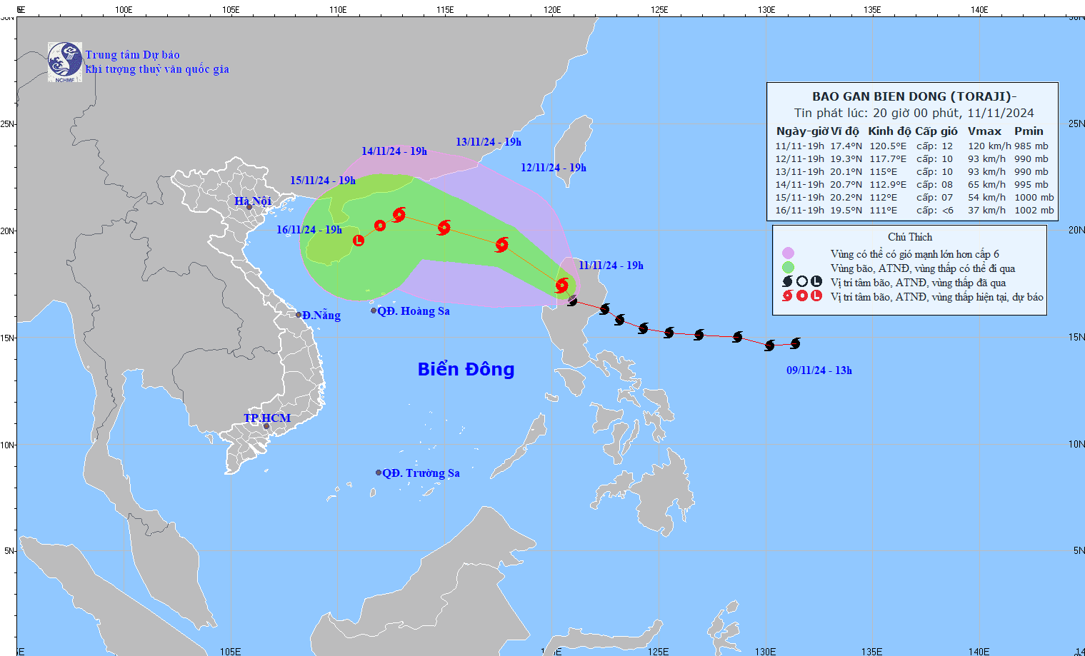
Updated location and path of Typhoon Toraji. Photo: NCHMF
Storm developments in the next 24 to 72 hours:
| Forecast time | Direction, speed | Location | Intensity | Danger zone | Disaster Risk Level (Affected Area) |
| 19h/12/11 | Northwest, about 20km/h, entering the East Sea | 19.3N-117.7E; in the eastern sea of the North East Sea area | Level 10, jerk level 12 | Latitude 15.5N-20.5N; East of longitude 115.0E | Level 3: East of the North East Sea area |
| 19h/13/11 | West Northwest, 10-15km/h | 20.1N-115.0E; in the northern sea area of the North East Sea | Level 9-10, jerk level 12 | Latitude 17.0N-22.0N; East of longitude 113.0E | Level 3: North East Sea area |
| 19:00/14/11 | West Northwest, about 10km/h and gradually weakening | 20.7N-112.9E; North of the North East Sea area | Level 8, level 10 jerk | Latitude 18.0N-22.0N; longitude 111.0E-117.0E | Level 3: North of the North East Sea area |
From the next 72 to 120 hours, the storm moved in the West Southwest direction, about 5km per hour, and continued to weaken.
Regarding the impact of storm Toraji: The eastern sea area of the North East Sea has strong winds of level 6-7, then increasing to level 8, the area near the storm's eye has winds of level 9-10, gusts of level 12, waves 3.0-5.0m high, the area near the storm's eye has waves of 5.0-7.0m; the sea is very rough.
Ships operating in the above mentioned dangerous areas are likely to be affected by storms, whirlwinds, strong winds and large waves.
Why does the East Sea continuously welcome storms/tropical depressions?
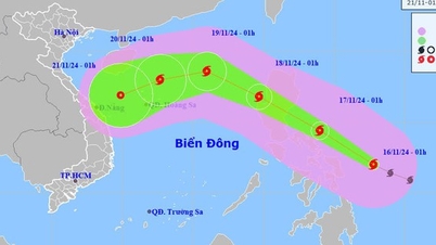
Mr. Nguyen Van Huong, Head of Weather Forecast Department, National Center for Hydro-Meteorological Forecasting, said that in addition to storm number 8 entering the East Sea in the coming hours, storm number 9 may appear in the East Sea in the coming days.
First, Typhoon Yinxing (Typhoon No. 7) has weakened into a tropical depression. Second, Typhoon Toraji is about to enter the South China Sea tonight (November 11) and become Typhoon No. 8, and Typhoon Man-yi is active in the far northwest Pacific.
Along with that, there is a tropical depression active between Typhoon Toraji and Typhoon Man-yi.
Why does the East Sea continuously welcome storms/tropical depressions?
According to Mr. Huong, all three storms and one tropical depression are located on the tropical convergence zone passing through the northern part of the East Sea. Storms and tropical depressions formed on the tropical convergence zone often move in the direction of the tropical convergence zone axis. This is the reason why the East Sea continuously welcomes storms or tropical depressions. There is a possibility of storm No. 8 and it is not excluded that storm No. 9 will appear in the near future in the East Sea.
"With such continuous storm forecasts, dangerous weather in the East Sea such as strong waves and strong winds will last for many days," Mr. Huong commented.
Regarding storm No. 7, Mr. Nguyen Van Huong said that due to the influence of storm No. 7's circulation, from the evening and night of November 11 to the end of November 12, there will be rain in the Central and South Central regions. From early morning of November 12 to November 13, in the area from Thua Thien Hue to Binh Dinh, there is a possibility of moderate to heavy rain, locally very heavy rain with common rainfall of 70-150mm, locally over 250mm. From the night of November 13, heavy rain will gradually decrease.
People in the central coastal areas, especially from Quang Tri to Quang Ngai, need to closely monitor the storm situation and prepare response plans to minimize risks.
Source: https://danviet.vn/chuyen-gia-ly-giai-nong-vi-sao-bien-dong-lien-tuc-don-bao-ngay-sau-bao-so-8-se-xuat-hien-bao-so-9-20241111202012876.htm
![[Photo] Ready for the top competitions of Vietnamese table tennis](https://vphoto.vietnam.vn/thumb/1200x675/vietnam/resource/IMAGE/2025/5/18/9c547c497c5a4ade8f98c8e7d44f5a41)


![[Photo] General Secretary To Lam visits exhibition of achievements in private economic development](https://vphoto.vietnam.vn/thumb/1200x675/vietnam/resource/IMAGE/2025/5/18/1809dc545f214a86911fe2d2d0fde2e8)


![[Photo] National conference to disseminate and implement Resolution No. 66-NQ/TW and Resolution No. 68-NQ/TW of the Politburo](https://vphoto.vietnam.vn/thumb/1200x675/vietnam/resource/IMAGE/2025/5/18/adf666b9303a4213998b395b05234b6a)


Comment (0)