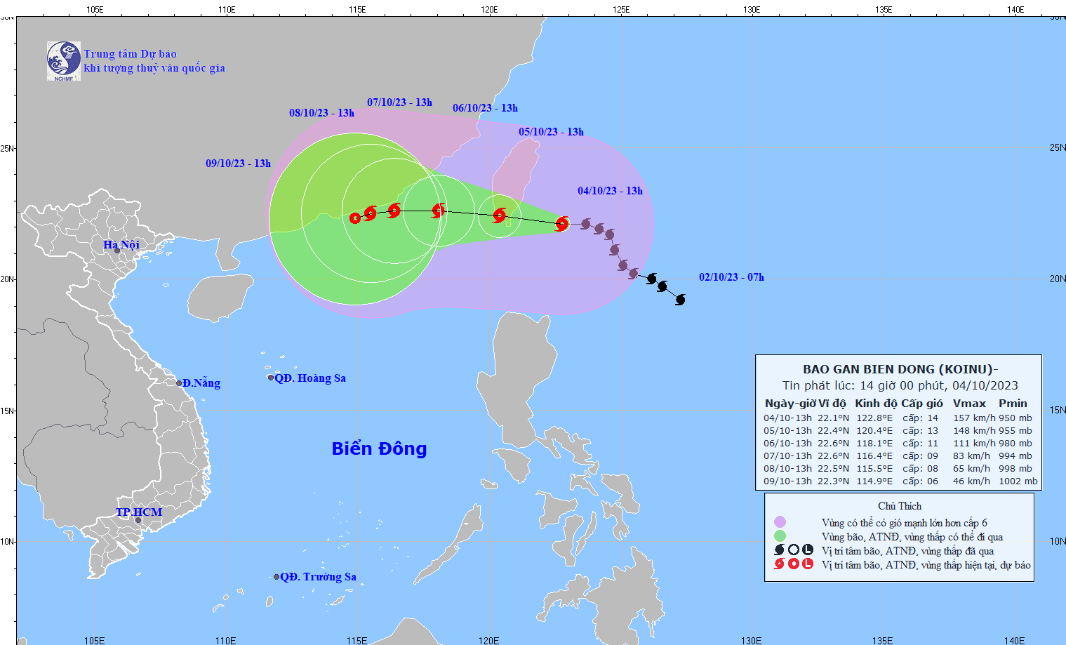
At 1 p.m. on October 4, the center of typhoon Koinu was at approximately 22.1 degrees North latitude; 122.8 degrees East longitude, in the sea southeast of Taiwan (China). Typhoon Koinu is forecast to hit the southern and eastern regions of China.
 |
| It is forecasted that storm Koinu will move mainly in the West Northwest direction. (Source: nchmf.gov.vn) |
Development and impact of storm Koinu
Current status of typhoon Koinu
The strongest wind near the storm center is level 14 (150-166km/h), gusting to level 17, moving west at a speed of about 15km/h.
Storm forecast (next 24 to 72 hours):
Forecast time | Direction, speed | Location | Intensity | Danger zone | Disaster risk level (Area affected) |
13:00 October 5 | West Northwest, about 10km/h | 22.4N-120.4E, in the area south of Taiwan Island (China) | Level 13, jerk level 16 | North of latitude 20.0N; East of longitude 118.0E | Level 3: Northeast of the North East Sea area |
13:00 October 6 | West Northwest, about 10km/h moving into the East Sea and gradually weakening | 22.6N-118.1E, 150km south of Fujian (China) | Level 10-11, jerk level 13 | North of latitude 20.0N; East of longitude 115.0E | Level 3: Northeast of the North East Sea area |
13:00 October 7 | West, 5-10km/h and further weakening | 22.6N-116.4E, in the sea southeast of Guangdong province (China) | Level 8-9, jerk level 11 | North of latitude 19.5N; East of longitude 114.0E | Level 3: North of the North East Sea area |
Warning of storm Koinu (from next 72 to 120 hours)
From the next 72 to 120 hours, the storm will move mainly in the West Southwest direction, about 5km per hour, and its intensity will continue to weaken.
Forecast of the impact of Typhoon Koinu
Strong wind
At sea:
The northeastern sea area of the North East Sea has strong winds of level 6-7, from the night of October 4 it will strengthen to level 8-10, from the afternoon of October 5 the area near the storm's eye will have winds of level 11-12, gusting to level 15; the sea will be very rough.
Rising water, big waves
The northeastern sea area of the North East Sea has waves 2-4m high; from the night of October 4, the waves are 4-6m high, from the afternoon of October 5, the area near the storm center has waves 6-8m high.
China responds urgently to Typhoon Koinu
On October 3, China's National Flood and Drought Prevention and Control Center activated a level IV emergency response to prepare for Typhoon Koinu, which is forecast to hit southern and eastern regions of the country.
The National Flood and Drought Prevention and Control Center, the Ministry of Emergency Management and relevant functional units of China have coordinated to deploy the direction of response to Typhoon Koinu and prevent and control storms and floods in localities.
Many working delegations have been sent to localities, including Guangdong and Hubei provinces, to strengthen preparations for storm response.
Reports indicate that Typhoon Koinu has strengthened into a super typhoon. From October 4 to 8, the coastal areas of southern China will experience strong winds and heavy rain, with very heavy rain in eastern and southern Fujian Province and eastern Guangdong Province.
Since the night of October 3, the southern areas of Gansu and Shaanxi provinces, the eastern areas of Sichuan and Chongqing provinces, the northern areas of Guizhou province, the western areas of Hubei province, and the western areas of Henan province have had moderate to heavy rain, with some places experiencing very heavy rain.
Chinese authorities require localities to strictly perform their functions and tasks of preventing and combating storms and floods, strengthen forecasting and early warning, promptly evacuate ships and boats to safe shelters, and prepare plans to evacuate people from dangerous areas.
Storm Koinu is a strong storm, the strongest wind near the storm center is level 14-15 (150-183 km/h), gusting over level 17, moving northwest, about 10km per hour.
It is forecasted that by 7:00 p.m. on October 5, the storm will move in a West-Northwest direction at a speed of about 10km/h, 280km East-Southeast of Fujian, with strong winds of level 12, gusting to level 15, then the storm will enter the East Sea.
Over the past 10 days, many localities in China have continuously experienced moderate to heavy rain. On September 18, the China National Flood and Drought Prevention and Control Center also activated a level IV flood emergency response for nine provinces and cities including Jiangsu, Anhui, Shandong, Henan, Hubei, Chongqing, Sichuan, Guizhou and Shaanxi.
China's emergency response system consists of four levels, with level IV being the lowest and level I being the highest.
Source


![[Photo] National Assembly Chairman Tran Thanh Man attends the Party Congress of the Committee for Culture and Social Affairs](https://vphoto.vietnam.vn/thumb/1200x675/vietnam/resource/IMAGE/2025/5/11/f5ed02beb9404bca998a08b34ef255a6)
![[Photo] General Secretary To Lam concludes visit to Russia, departs for Belarus](https://vphoto.vietnam.vn/thumb/1200x675/vietnam/resource/IMAGE/2025/5/11/0acf1081a95e4b1d9886c67fdafd95ed)


![[Photo] Discover the beautiful scenery of Wulingyuan in Zhangjiajie, China](https://vphoto.vietnam.vn/thumb/1200x675/vietnam/resource/IMAGE/2025/5/11/1207318fb0b0467fb0f5ea4869da5517)


Comment (0)