
According to the latest storm information from the National Center for Hydro-Meteorological Forecasting, at 10:00 a.m. on July 22, the center of storm No. 2 (Prapiroon) was located at about 19.8 degrees North latitude; 109.0 degrees East longitude, in the eastern sea of the northern Gulf of Tonkin, about 150km southeast of Bach Long Vi.
The strongest wind near the storm center is level 9-10 (75-102km/h), gusting to level 12, moving northwest at a speed of 10-15km/h.
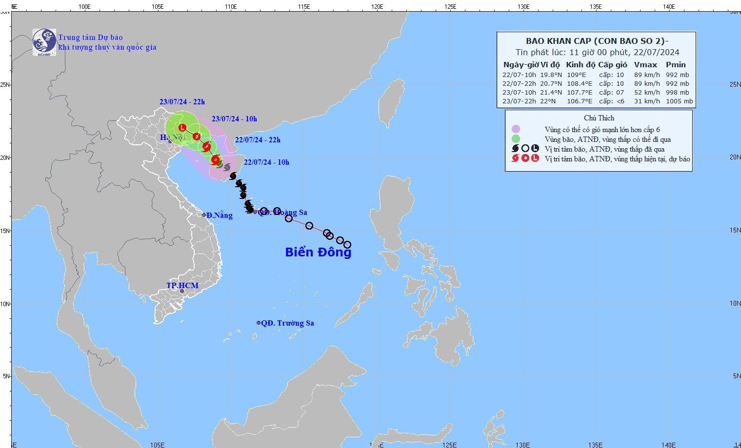
In the next 24 – 72 hours, storm No. 2 will continue to move northwest. At around 10:00 p.m. on July 22 , the center of the storm will be at approximately 20.7 degrees North latitude – 108.4 degrees East longitude; in the northern area of the Gulf of Tonkin; approximately 110km east of Quang Ninh – Hai Phong .
The strongest wind near the storm center is level 10, gusting to level 12, moving northwest at a speed of 10km/h.
At 10:00 a.m. on July 23 , the center of the storm was at approximately 21.4 degrees North latitude - 107.7 degrees East longitude; on the coastal mainland of Quang Ninh - Hai Phong provinces.
At 10:00 p.m. on July 23 , storm No. 2 reached the Vietnam-China border area and weakened, with wind intensity below level 6.
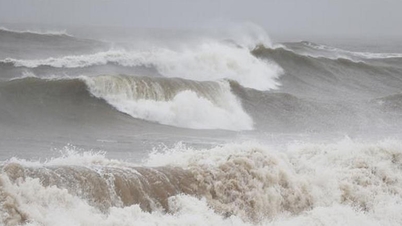
The Meteorological Agency forecasts that storm No. 2 will cause strong winds at sea: The northwestern sea area of the North East Sea this afternoon will have strong winds of level 6-7, gusts of level 9, and rough seas. The sea area of the Gulf of Tonkin (including Bach Long Vi and Co To islands) will have strong winds of level 6-7, the area near the storm's center will have strong winds of level 9-10, gusts of level 12, and very rough seas.
On land, from tonight, coastal areas of Quang Ninh - Hai Phong provinces are likely to be affected by strong winds of level 6-7, gusting to level 9.
In particular, the storm caused rising water and big waves: The Northwestern sea area of the North East Sea this afternoon had waves 2-4m high. The North Gulf of Tonkin sea area (including Bach Long Vy and Co To islands) had waves 2.5-4.5m high, and the coastal sea area of Quang Ninh - Hai Phong province had waves 2-3m high.
Coastal areas of Quang Ninh - Nam Dinh provinces should be on guard against high tides (in the afternoon of July 22-23) accompanied by rising water and big waves causing flooding in low-lying areas, slowing down the flood drainage process on rivers in the area.
In addition, from the night of July 22 to July 24, in the Northern region and Thanh Hoa, there is a possibility of moderate rain, heavy rain and thunderstorms, locally very heavy rain with the following total rainfall: Northeast region 100-200mm, some places over 300mm; Northwest region and Thanh Hoa 50-100mm, some places over 200mm.


![[Photo] Prime Minister Pham Minh Chinh and Prime Minister of the Kingdom of Thailand Paetongtarn Shinawatra attend the Vietnam-Thailand Business Forum 2025](https://vphoto.vietnam.vn/thumb/1200x675/vietnam/resource/IMAGE/2025/5/16/1cdfce54d25c48a68ae6fb9204f2171a)


![[Photo] President Luong Cuong receives Prime Minister of the Kingdom of Thailand Paetongtarn Shinawatra](https://vphoto.vietnam.vn/thumb/1200x675/vietnam/resource/IMAGE/2025/5/16/52c73b27198a4e12bd6a903d1c218846)


Comment (0)