
According to the National Center for Hydro-Meteorological Forecasting, due to the influence of storm circulation No. 2 (Prapiroon), on Bach Long Vi island, there were strong winds of level 10, gusting to level 12; on Co To island, there were strong winds of level 6, gusting to level 9; at Cua Ong, there were strong winds of level 6, gusting to level 7; Dam Ha (Quang Ninh) had strong winds of level 6, gusting to level 9. At the same time, in the coastal areas of the Northeast, there was moderate rain, heavy rain, and in some places, very heavy rain such as: Cat Ba ( Hai Phong ) 215mm, Van Don (Quang Ninh) 108mm, ...
As of 4am this morning (July 23), the eye of the storm was located on the coastal area of Quang Ninh - Hai Phong. The strongest wind near the eye of the storm was level 8-9 (62-88km/h), gusting to level 11, moving northwest at a speed of about 10km/h.
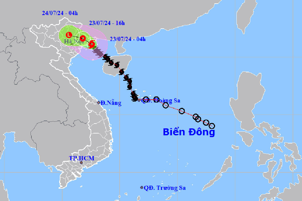
Thus, compared to last night, storm No. 2 has decreased by 1-2 levels, from the highest level of this wave being level 10, gusting to level 13. According to forecasts, in the coming hours, the storm will move in the West-Northwest direction at a speed of about 5-10km/h, deep inland and continue to weaken into a tropical depression. At 4:00 p.m., the center of the tropical depression will be over the Northeast region with winds of level 6, gusting to level 8.
By 4am tomorrow morning (July 24), the tropical depression will maintain its direction of movement, at a speed of 10km/h, weakening into a low pressure area over the northern mountainous region.
According to the meteorological agency, due to the influence of storm No. 2, last night and early this morning, in the Northeast region, there was moderate rain, locally heavy to very heavy rain. The rainfall from 7:00 p.m. on July 22 to 3:00 a.m. was locally over 80mm in some places, such as: Ha Long City (Quang Ninh) 85.6mm, Cat Hai (Hai Phong) 151.8mm, ... According to experts, the rain after the storm will be very heavy.
Specifically, from this morning to tomorrow (July 24), in the Northeast region, there will be widespread heavy rain with total rainfall ranging from 100-200mm, locally over 300mm. From the night of July 24, heavy rain in the Northeast region will gradually decrease.
From this morning to tomorrow night, the Northwest region and Thanh Hoa will also have moderate rain, heavy rain and thunderstorms, locally very heavy rain with total rainfall from 50-100mm, locally over 200mm.
In addition, this afternoon and tonight, in the area from Nghe An to Quang Tri, the Central Highlands and the South, there will be showers and thunderstorms, locally heavy rain with rainfall from 15-30mm, locally over 70mm. From July 25, heavy rain in the Northwest and Thanh Hoa will tend to decrease gradually.
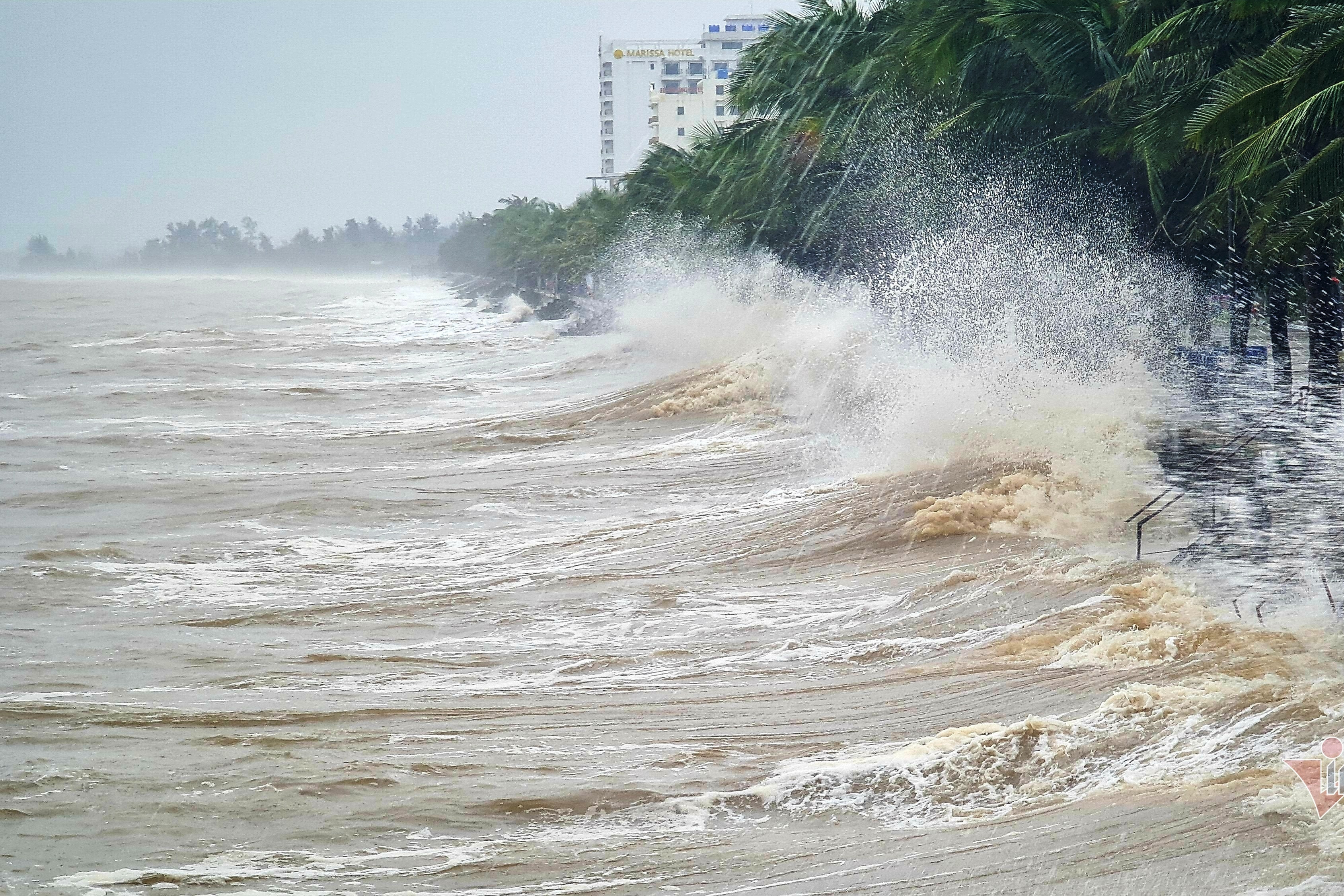
Regarding the weather at sea, the Gulf of Tonkin (including Bach Long Vi and Co To islands) has strong winds of level 6-7, the area near the storm's eye has strong winds of level 8-9, gusts of level 11, very rough seas; wave height 2-4m, coastal waters of Quang Ninh - Hai Phong have waves of 2-3m high.
On land, the Quang Ninh - Hai Phong area has strong winds of level 6-7, near the storm center level 8, gusting to level 10; the Lang Son, Bac Giang, Thai Binh areas have strong winds of level 5, in some places level 6, gusting to level 7.
This afternoon, the coastal areas of the provinces from Quang Ninh to Nam Dinh have high tides, with water levels at Hon Dau 3.8-4m and Cua Ong 4.6-4.8m, slowing down the flood drainage process on rivers, causing flooding in low-lying coastal and riverside areas.
Previously, on July 22, Mr. Nguyen Van Huong, Head of the Weather Forecast Department, National Center for Hydro-Meteorological Forecasting, warned: "With heavy and intense rainfall in a short period of time, most mountainous areas, midlands of the North as well as the western region of Thanh Hoa, even the western part of Nghe An province need to be on guard against flash floods and landslides."
As for Hanoi's weather, although not directly affected by storm No. 2, the storm's circulation will cause moderate to heavy rain with rainfall in the East of about 100mm, in some places over 100mm.
Storm No. 2 is gusting at level 13 in the Gulf of Tonkin, with heavy rain in the North starting tonight . Storm No. 2 is gusting at level 13 in the Gulf of Tonkin and moving towards Quang Ninh - Hai Phong. Meteorological experts warn of heavy rain, especially in the Northeast starting tonight.


![[Photo] Prime Minister Pham Minh Chinh and Prime Minister of the Kingdom of Thailand Paetongtarn Shinawatra attend the Vietnam-Thailand Business Forum 2025](https://vphoto.vietnam.vn/thumb/1200x675/vietnam/resource/IMAGE/2025/5/16/1cdfce54d25c48a68ae6fb9204f2171a)


![[Photo] President Luong Cuong receives Prime Minister of the Kingdom of Thailand Paetongtarn Shinawatra](https://vphoto.vietnam.vn/thumb/1200x675/vietnam/resource/IMAGE/2025/5/16/52c73b27198a4e12bd6a903d1c218846)


Comment (0)