
Latest news on storm number 2: After 10am this morning, storm number 2 with level 10 gusts will enter the North Gulf of Tonkin
According to the latest storm No. 2 bulletin of the National Center for Hydro-Meteorological Forecasting, at 7:00 a.m. this morning (July 22), the center of storm No. 2 was at about 19.6 degrees North latitude; 109.3 degrees East longitude, strongest wind: Level 8-9 (62-88km/h), gusting to level 11. Forecast: In the next 3 hours, the storm will move northwest at a speed of about 15km/h.

Update on the location and direction of storm No. 2: Storm No. 2 entered the Gulf of Tonkin today (July 22).
Latest forecast of storm No. 2 in the next 24 to 72 hours
Forecast of impact of storm No. 2
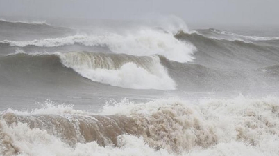
At sea: The northwestern sea area of the North East Sea this morning (July 22) still has strong winds of level 6-7, near the eye of the storm it is strong at level 8, gusts of level 10, rough seas. The northern sea area of the Gulf of Tonkin (including Bach Long Vi and Co To islands) has winds gradually increasing to level 6-7, near the eye of the storm it is strong at level 8, gusts of level 10, rough seas.
On land: From early morning on July 23, coastal areas of Quang Ninh province are likely to be affected by strong winds of level 6, gusting to level 8.
Rising water, big waves: The sea in the northwest of the North East Sea this morning (July 22) had waves 2.0-4.0m high. The sea in the northern Gulf of Tonkin (including Bach Long Vi and Co To islands) had waves gradually increasing to 2.0-4.0m, and the sea in the coastal area of Quang Ninh province had waves 1.5-2.5m high.
Heavy rain: From the night of July 22 to July 24, in the Northern region and Thanh Hoa, there is a possibility of moderate rain, heavy rain and thunderstorms, locally very heavy rain with the total rainfall as follows:
- Northern coastal areas and Northeastern regions: 100-200mm, some places over 250mm.
- Other places in the North and Thanh Hoa: 50-100mm, some places over 150mm.
Strong winds, big waves and thunderstorms at sea forecast due to the impact of storm No. 2
The tropical convergence zone has an axis at about 17-19 degrees North latitude connecting with storm No. 2, internationally named PRAPIROON, at 01:00 on July 22, located at about 18.7 degrees North latitude; 110.2 degrees East longitude.
On Phu Quy and Huyen Tran islands, there were strong winds of level 5, sometimes level 6, gusting to level 8. The eastern sea of the North and middle of the East Sea and the Gulf of Thailand had showers and thunderstorms.
Source: https://danviet.vn/tin-bao-khan-cap-sau-10h-sang-nay-bao-so-2-giat-cap-10-se-di-vao-bac-vinh-bac-bo-20240722074350756.htm


![[Photo] Nearly 3,000 students moved by stories about soldiers](https://vphoto.vietnam.vn/thumb/1200x675/vietnam/resource/IMAGE/2025/5/17/21da57c8241e42438b423eaa37215e0e)

![[Photo] Readers line up to visit the photo exhibition and receive a special publication commemorating the 135th birthday of President Ho Chi Minh at Nhan Dan Newspaper](https://vphoto.vietnam.vn/thumb/1200x675/vietnam/resource/IMAGE/2025/5/17/85b3197fc6bd43e6a9ee4db15101005b)


Comment (0)