
Latest storm news: Typhoon Yinxing is forecast to have a high chance of entering the East Sea and becoming storm number 7. If the storm enters the East Sea, the possibility of heavy rain in the Central region ending sooner than forecast.
Typhoon Yinxing has formed, forecast to enter the East Sea and become storm number 7
The tropical depression east of the Philippines has strengthened into Typhoon Yinxing, which is expected to intensify rapidly. Currently, all forecast models predict that this storm will enter the East Sea and thus, it will become Typhoon No. 7 as our country calls it.
The tropical depression mentioned in the previous bulletin has intensified into Typhoon Yinxing (China-proposed name; known as Typhoon Marce in the Philippines) and entered the Philippine Area of Responsibility (PAR) early this morning, November 4.
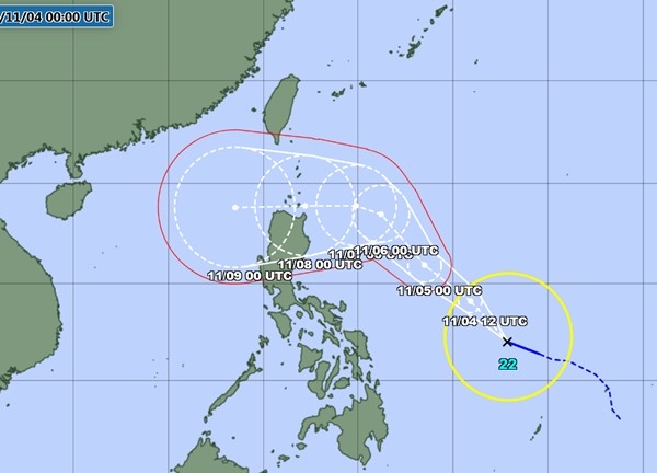
JMA's forecast of the path of Typhoon Yinxing. Photo: JMA.
According to the announcement early this morning by the US Joint Typhoon Warning Center (JTWC), Typhoon Yinxing is currently east of the Philippines, with winds of 75 km/h (level 9), and is forecast to move northwest over the next 2 days while continuing to strengthen. Typhoon Yinxing could reach winds of 150 - 155 km/h (level 14) when it approaches or makes landfall in the northern Philippines.
Currently, all major forecast models, including those of the JTWC, the Japan Meteorological Agency (JMA), the UKM of the United Kingdom and the ECMWF of Europe, all predict that Typhoon Yinxing will move quite deep into the East Sea. When the models have agreed like that, it can be understood that Typhoon Yinxing will almost certainly become Typhoon No. 7 as our country calls it. The time when Typhoon Yinxing enters the East Sea is around November 8-9 (Friday to Saturday this week).
It is noteworthy that according to current forecasts, when entering the East Sea, Typhoon Yinxing may still maintain very strong intensity, with winds of 125 - 130 km/h (level 12), also known as a typhoon, according to JTWC and JMA.
After Typhoon Yinxing entered the East Sea, forecast models became quite different because the storm will be affected by many factors, moreover, forecasting the storm so far away is not very certain. However, because the storm is still very strong when entering the East Sea and the development is unpredictable, people should pay attention to regularly follow the news to get updated information about this storm.
Heavy rain in Central Vietnam likely to end earlier than forecast
According to the National Center for Hydro-Meteorological Forecasting, the latest assessment of the flood situation in the Central region has just been released. Accordingly, in previous forecasts, the meteorological agency said that the flood situation in the Central region will last until November 10, then there will be two more consecutive floods, with the situation still complicated.
However, at this time, the meteorological agency believes that heavy rain in the central provinces is likely to last until around November 8. Thunderstorms may include tornadoes, lightning, and strong gusts of wind.
According to Mr. Mai Van Khiem, Director of the National Center for Hydro-Meteorological Forecasting, after November 10, heavy rains in the Central region will continue to develop complicatedly with the possibility of 2-3 heavy rains. In the first half of November, it will be concentrated in the provinces from Ha Tinh to Quang Ngai, the second half of November and early December will be concentrated in the provinces from Quang Binh to Phu Yen.
According to the meteorological agency, last night and this morning (November 4), in the area from Ha Tinh to Thua Thien Hue, there was moderate rain, heavy rain, and some places had very heavy rain. The rainfall from 7pm on November 3 to 8am on November 4 was over 100mm in some places such as: Kim Thuy (Quang Binh) 113.6mm, Hai An (Quang Tri) 245.4mm, Dien Huong (Thua Thien Hue) 141.8mm,...
It is forecasted that from November 4 to the morning of November 6, the area from Ha Tinh to Quang Ngai will have heavy to very heavy rain with rainfall from 150-250mm, locally over 400mm. Warning of the risk of localized heavy rain (>150mm/6 hours).
From November 4 to the night of November 5, the Thanh Hoa-Nghe An area will have moderate rain, heavy rain and scattered thunderstorms, locally very heavy rain with rainfall from 50-150mm, locally over 200mm.
In addition, on the day and night of November 4, in the Southern Central Highlands and the Southern region, there will be scattered showers and thunderstorms, locally heavy rain with rainfall from 15-30mm, locally over 60mm (thunderstorms are concentrated in the afternoon and evening).
Warning, in the afternoon and night of November 6, in the area from Quang Binh to Binh Dinh, there will be heavy rain, locally very heavy rain and thunderstorms with common rainfall of 50-100mm, locally over 150mm; in the area from Quang Tri to Quang Ngai, common rainfall will be 100-200mm, locally over 250mm.
Source: https://danviet.vn/mot-con-bao-hinh-thanh-ngoai-khoi-philippines-co-kha-nang-di-vao-bien-dong-tro-thanh-con-bao-so-7-20241104114922467.htm
![[Photo] Magical moment of double five-colored clouds on Ba Den mountain on the day of the Buddha's relic procession](https://vphoto.vietnam.vn/thumb/1200x675/vietnam/resource/IMAGE/2025/5/9/7a710556965c413397f9e38ac9708d2f)
![[Photo] General Secretary To Lam and international leaders attend the parade celebrating the 80th anniversary of the victory over fascism in Russia](https://vphoto.vietnam.vn/thumb/1200x675/vietnam/resource/IMAGE/2025/5/9/4ec77ed7629a45c79d6e8aa952f20dd3)
![[Photo] Russian military power on display at parade celebrating 80 years of victory over fascism](https://vphoto.vietnam.vn/thumb/1200x675/vietnam/resource/IMAGE/2025/5/9/ce054c3a71b74b1da3be310973aebcfd)
![[Photo] Prime Minister Pham Minh Chinh chairs a special Government meeting on the arrangement of administrative units at all levels.](https://vphoto.vietnam.vn/thumb/1200x675/vietnam/resource/IMAGE/2025/5/9/6a22e6a997424870abfb39817bb9bb6c)


Comment (0)