
On November 2, the National Center for Hydro-Meteorological Forecasting continued to issue a warning about heavy rain in the Central region in the coming days.
Accordingly, there is currently localized rain in the Central region. It is forecasted that from early morning to tomorrow night (November 3), the area from Ha Tinh to Quang Ngai will have moderate rain, heavy rain and scattered thunderstorms, locally very heavy rain with rainfall from 40-100mm, locally over 200mm.
During the day and night of November 4, the rain spread to Thanh Hoa area with rainfall of 70-150mm, locally over 300mm; in the area from Ha Tinh to Da Nang, rainfall was 100-200mm, locally over 350mm.
The meteorological agency emphasized the level 2 warning of natural disaster risks due to heavy rain, tornadoes, and lightning in the area from Ha Tinh to Da Nang.
Heavy rain in the central provinces is forecast to last for many days and may extend down to Binh Dinh.
Commenting on this heavy rain, Mr. Mai Van Khiem, Director of the National Center for Hydro-Meteorological Forecasting, said that around November 3-4, there is a possibility of a low-pressure area forming in the East Sea, which could strengthen into a tropical depression. Also in the first days of November, a strong cold air mass will move down to our country around November 4-7.
The combination of a cyclone, cold air, easterly wind disturbances and the windward terrain of the Truong Son mountain range will create a period of intense heavy rain in the central provinces. Rain is forecast from around November 3-10.
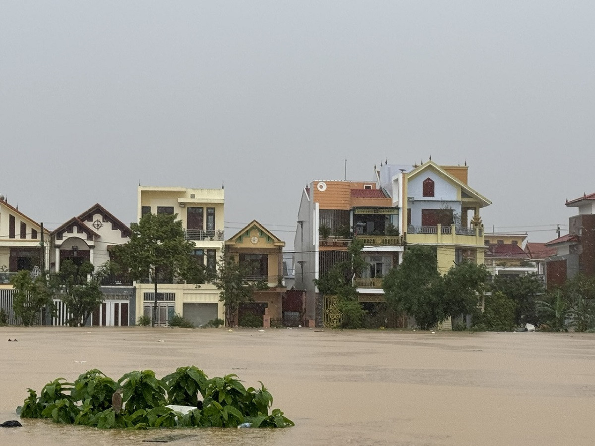
“This is a widespread heavy rain, especially heavy rain, causing major floods above alert level 3 in the Northern and Central Central provinces; widespread flooding, flash floods, and landslides in mountainous areas,” Mr. Khiem emphasized.
Notably, the heavy rain area is not only concentrated in the provinces that have had very heavy rain in recent days (Ha Tinh to Da Nang), but also extends to the southern part, specifically the provinces from Quang Nam to Phu Yen.
Dr. Nguyen Ngoc Huy, an expert on climate change and natural disaster warning, also commented that the heavy rain pattern from November 3-10 (possibly longer) in the Central region is relatively similar to the flood pattern in October 2020.
The rain will roll from the South Central region to the North Central region due to low pressure from November 3-5 in the Quang Ngai to Ha Tinh areas. Then from November 6-10, strong humid northeast winds will blow from the Taiwan Strait (China) and cause rain to return from the North Central region to the Central Central region and South Central region.
“This is the most worrying stage because the waves will be about 2.5-3m high along the northeast coast, making it difficult for water to escape,” Mr. Huy noted.
In addition, Mr. Khiem added that after November 10, heavy rain in the Central region will continue to have complicated developments with the possibility of 2-3 heavy rains, in which the first half of November will be concentrated in the provinces from Ha Tinh to Quang Ngai, the second half of November and early December will be concentrated in the provinces from Quang Binh to Phu Yen.
The heavy rains in early November have caused many concerns. This is also the peak period of flooding in the Central region this year. “We warn of a high risk of major floods, an especially high risk of flash floods and serious landslides in the Central provinces, along with widespread inundation,” Mr. Khiem noted.
Cold air increases in frequency and intensity
Regarding the strong cold spell forecast to hit the North from the night of November 4, the meteorological agency said that this is the first widespread cold spell of this winter, with localized cold in mountainous areas.
During the month of November, the National Center for Hydro-Meteorological Forecasting said that storms/tropical depressions in the East Sea and affecting Vietnam's mainland are likely to be at a level approximately equal to the multi-year average (TBNN) for the same period (TBNN in the East Sea: 1.5 storms; landfall: 0.9 storms).
Cold air during the forecast period will continue to increase in frequency and intensity, especially in the first 10 days of the month, potentially causing the first cold spell in 2024.
At the same time, the Central region is likely to experience widespread heavy rains (mainly concentrated from southern Nghe An to Khanh Hoa). The Central Highlands and the South continue to experience many days of showers and thunderstorms, including some days of moderate and heavy rain.
During this period, total rainfall in regions across the country is generally 15-40% higher than the average; in particular, the midland provinces, the mountainous regions of the North, the South Central Coast and the Central Highlands are generally at a level approximately equal to the average for the same period.
Forecast of the meteorological situation nationwide from November 2-8: Northern Region From 2-3/11: no rain at night, sunny during the day, early morning fog in some places. Cold at night and early morning, freezing in mountainous areas. From November 4-6: scattered showers and thunderstorms, some places have heavy rain; on the night of November 5 and 6, there will be rain in some places. Cold weather, some places have severe cold in the highlands. Thunderstorms may have tornadoes, whirlwinds and strong gusts of wind. From November 7-8: no rain at night, sunny during the day, some places have fog in the early morning. Cold at night and early morning. Central Region November 2: rain in some places, especially in the South Central region with scattered showers and thunderstorms in some places. From November 3-5: The North and Central Central regions will have heavy rain, locally very heavy rain and thunderstorms. The South Central region will have scattered showers and thunderstorms. From the night of November 4, the North Central region will turn cold. From November 6-8: Ha Tinh to Binh Dinh areas will have heavy rain, locally very heavy rain and thunderstorms; other areas will have scattered showers and thunderstorms, locally heavy rain. Thunderstorms may produce tornadoes, hail and strong winds. From November 4-8, there is a possibility of a flood on rivers in the area from Ha Tinh to Quang Ngai. The peak water level on rivers in Ha Tinh is likely to reach storm level 1, on rivers in the Central Central region from Quang Binh to Quang Ngai at level 2-3, some rivers above level 3. From November 6-8, water levels of rivers in Binh Dinh in the South Central region are likely to fluctuate. There is a high risk of flash floods and landslides in mountainous areas, localized flooding in low-lying areas along rivers and urban areas in provinces from Ha Tinh to Quang Ngai. Central Highlands and Southern Region From November 2-8: there will be showers and thunderstorms in some places; in the late afternoon and evening there will be scattered showers and thunderstorms, with heavy rain in some places. Water levels on rivers in the Northern Central Highlands are likely to fluctuate strongly from November 4-8. Hanoi area From 2-3/11: no rain at night, sunny during the day, some places have fog in the early morning. Cold at night and early morning. From November 4-6: scattered showers and thunderstorms, locally heavy rain; on the night of November 5 and 6, there will be rain in some places. Cold weather. Thunderstorms may cause tornadoes, whirlwinds and strong gusts of wind. From 7-8/11: no rain at night, sunny during the day, some places have fog in the early morning. Cold at night and early morning. At sea : From November 2-8, wave height in the East Sea (including Hoang Sa and Truong Sa archipelagos), the Gulf of Tonkin, and the sea area from Quang Tri to Ninh Thuan tends to increase gradually. In the North East Sea (including Hoang Sa archipelago) and Quang Tri to Quang Ngai, waves are 4-6m high, with rough seas. In the Central East Sea, waves are 3-5m high, with rough seas. In the Gulf of Tonkin, Binh Dinh - Ninh Thuan, the South East Sea, and Truong Sa archipelago, waves range from 2-4.5m, with rough seas. |

Cold air diffuses, HCMC weather has many surprises in November
Ho Chi Minh City weather in November begins to be affected by cold air waves that strengthen and diffuse southward. It is forecasted that by the end of the month, the rainy season in the South will end and the dry season will begin.
Cold air is coming, some places in the North are 15 degrees
Around the evening and night of November 1, the first cold air mass of November began to move in; followed by a stronger one. The lowest temperature in the North is forecast to be between 18-21 degrees Celsius, and in some mountainous areas below 15 degrees Celsius.

![[Photo] Prime Minister Pham Minh Chinh chairs a special Government meeting on the arrangement of administrative units at all levels.](https://vphoto.vietnam.vn/thumb/1200x675/vietnam/resource/IMAGE/2025/5/9/6a22e6a997424870abfb39817bb9bb6c)

![[Photo] Magical moment of double five-colored clouds on Ba Den mountain on the day of the Buddha's relic procession](https://vphoto.vietnam.vn/thumb/1200x675/vietnam/resource/IMAGE/2025/5/9/7a710556965c413397f9e38ac9708d2f)


Comment (0)