
A double hurricane is a special meteorological phenomenon that occurs when two storms coexist and interact closely with each other. This phenomenon becomes complicated and dangerous due to the change in intensity and direction of both storms.
Not only does this make forecasting difficult, it can also increase the strength of the storm, causing more severe consequences when it makes landfall.
Double storm phenomenon and Fujiwhara effect
The phenomenon of twin storms occurs when two storms are within 1,000-1,500 km of each other, close enough to begin interacting and orbiting each other in a common orbit. This interaction is often called the Fujiwhara effect, named after Japanese meteorologist Sakuhei Fujiwhara, who first described the phenomenon in 1921.
The phenomenon of two or more storms overlapping occurs when they form close together.
According to the Fujiwhara effect, when two storms approach each other, they tend to be pulled in and rotate around a common center. In some cases, one storm will intensify due to this interaction, the other will weaken, or the two may merge to form a super typhoon.
Why is the double storm phenomenon dangerous?
Twin storms are considered particularly dangerous because the interaction between storms creates unpredictable changes in intensity and direction, making it difficult to forecast and respond to emergencies. According to meteorological experts, the following are the main reasons why twin storms are dangerous:
Difficult to predict paths: The interaction between two storms causes them to move in irregular and unpredictable trajectories. This forces meteorological agencies to constantly adjust forecasts, making it difficult to provide early warning and prepare for response.
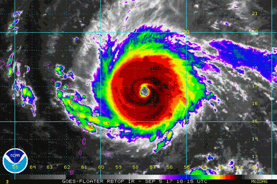
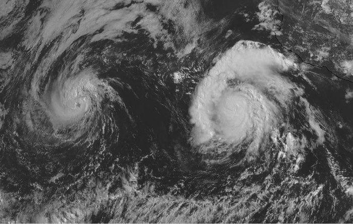
Satellite image of a hurricane.
Hurricane Intensification: As two storms approach each other, the strong vortices from the two storms can increase their winds and make the storm more dangerous. The two can merge into a super typhoon, which can cause devastating effects when it makes landfall.
Expanded Area of Impact: Two storms can create a larger area of impact, bringing heavy rain and strong winds over a large area. Especially in coastal or lowland areas, torrential rains, landslides, and flooding caused by twin storms can cause great loss of life and property.
According to hydrometeorological experts in Vietnam, the Fujiwhara effect is a rare and complex phenomenon that requires close monitoring by meteorological agencies. He emphasized that: "The double storm phenomenon not only makes forecasting difficult but also creates strong winds and heavy rain over a large area, causing the risk of flooding and serious damage to coastal areas."
Sharing the same view, Dr. Jeff Masters, a famous meteorologist in the US, said that the phenomenon of double storms has caused many big storms in the world. According to him, dealing with double storms requires stronger preventive measures because of the complexity and unpredictability of this phenomenon. Especially in the context of global climate change causing ocean temperatures to increase, double storms tend to occur more often and become more dangerous.
Cases of double storms in the world and in Vietnam recently
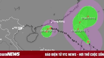
The latest storm news at 2:00 p.m. on November 10 from the Philippine Atmospheric, Geophysical and Astronomical Services Administration (PAGASA) said that the center of storm Toraji (called Nika in the Philippines) was at about 15.1 degrees north latitude, 125.6 degrees east longitude, 425km east of Infanta, Quezon, Philippines.
The storm is continuing to strengthen, moving west at 30 km/h. Toraji is expected to make landfall in Isabela or Aurora on or early Monday afternoon, November 11. It will then move across mainland Luzon, where it is expected to “briefly weaken,” and into the South China Sea as a Category 8 storm by the evening of November 11, where it could re-strengthen.
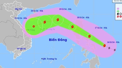
Meanwhile, at 1 p.m. on November 10, the center of storm No. 7 Yinxing was at about 18.8 degrees north latitude; 113.0 degrees east longitude, in the western sea area of the northern East Sea, about 240 km north-northeast of Vietnam's Hoang Sa archipelago. The strongest wind near the storm's center reached level 12 (118-133 km/h), gusting to level 14. The storm moved southwest at a speed of about 5 km/h.
According to the Vietnam National Center for Hydro-Meteorological Forecasting, storm No. 7 is moving into an area with unfavorable environmental conditions for storm development; because the current sea surface temperature in the western area of the Hoang Sa region is below the optimal level, below 26 degrees Celsius, reducing the energy supply for the storm, contributing to its gradual weakening.
It is forecasted that within the next 24-48 hours, storm No. 7 is expected to continue moving southwest and its intensity will rapidly decrease to below level 10.
It is forecasted that on the morning of November 11, when moving into the eastern area of Luzon Island of the Philippines, the distance between storm No. 7 (Yinxing) and storm Toraji will be about 1,200-1,400 km, which is the distance where the double storm interaction occurs, storm Toraji will cause storm No. 7 (Yinxing) to deviate more to the south.
Under the impact of these two storms, the northern and central regions of the East Sea will continuously experience bad weather in the coming days, with strong winds, high waves and rough seas.
Twin storms have been recorded in several regions around the world, including the Atlantic and Pacific Oceans. In 2017, hurricanes Irma and Jose appeared together in the Atlantic Ocean and interacted, causing strong winds and heavy rains across a wide area from the Caribbean Islands to the East Coast of the United States.
Also in 2017, two tropical storms Nesat and Haitang occurred close together and impacted Taiwan. Typhoon Nesat made landfall in Taiwan with strong winds, and Haitang soon approached, bringing heavy rain and severe flooding. The interaction between the two storms greatly affected forecasting, forcing authorities to prepare for a double impact from both storms.
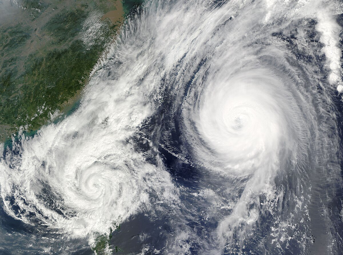
Illustration photo.
In Vietnam, although the phenomenon of double storms is less common, it is not impossible. According to the National Center for Hydro-Meteorological Forecasting, when two storms approach each other in the East Sea, they can impact and change their paths, affecting the exact forecast of the location and time of landfall.
In 2020, two strong storms, Goni and Atsani, formed together in the West Pacific and the East Sea. Goni was a category 5 super typhoon, causing severe damage in the Philippines, then made landfall in Vietnam with a weakened intensity. Atsani, moving near the Japanese region, although not directly making landfall, the interaction between the two storms changed its course and caused difficulties in forecasting in Vietnam and surrounding countries.
These are just a few examples that illustrate the dangers of twin storms, especially when they interact closely, increasing unpredictability and expanding the area of impact. Meteorologists recommend close monitoring and early warning to minimize damage when twin storms occur.
Measures to cope with double storm phenomenon
To minimize damage caused by the twin storms, meteorological agencies recommend improving forecasting and early warning, especially in the context of increasingly complex climate change. In addition, experts also suggest:
Strengthening coastal infrastructure : Coastal structures such as houses, seawalls, and ports need to be built solidly and designed to withstand storms.
Strengthening warning systems: Upgrading early warning systems can help people and local authorities prepare to respond promptly to the complex developments of the double storm.
Community training: Educating communities on how to respond and evacuate during a double hurricane warning is a practical measure to minimize loss of life and property.
Typhoon-induced storms pose a major challenge to forecasting and disaster response, especially in the context of global warming. Understanding and being prepared for typhoon-induced storms not only helps to minimize damage but also ensures people’s safety. With preventive measures and early warning, coastal countries, including Vietnam, can better cope with the complex developments of this phenomenon.
Source: https://danviet.vn/nong-hien-tuong-bao-doi-la-gi-khi-hai-con-bao-bat-tay-nhau-se-nguy-hiem-ra-sao-20241110160941856.htm


![[Photo] Prime Minister Pham Minh Chinh chairs conference on anti-smuggling, trade fraud, and counterfeit goods](https://vphoto.vietnam.vn/thumb/1200x675/vietnam/resource/IMAGE/2025/5/14/6cd67667e99e4248b7d4f587fd21e37c)


Comment (0)