
Latest storm news: According to the latest update from the National Center for Hydro-Meteorological Forecasting, at 10:00 a.m. on November 12, the center of the storm was located at approximately 18.7 degrees North latitude; 118.5 degrees East longitude, in the eastern sea of the North East Sea. The strongest wind near the center of the storm is level 9-10 (75-102 km/h), gusting to level 12.
Latest storm news: Update on the location and path of storm number 8
At 10:00 a.m. on November 12, the center of the storm was located at approximately 18.7 degrees North latitude; 118.5 degrees East longitude, in the eastern sea of the North East Sea. The strongest wind near the center of the storm was level 9-10 (75-102 km/h), gusting to level 12. Moving in the West Northwest direction, speed about 10 km/h.
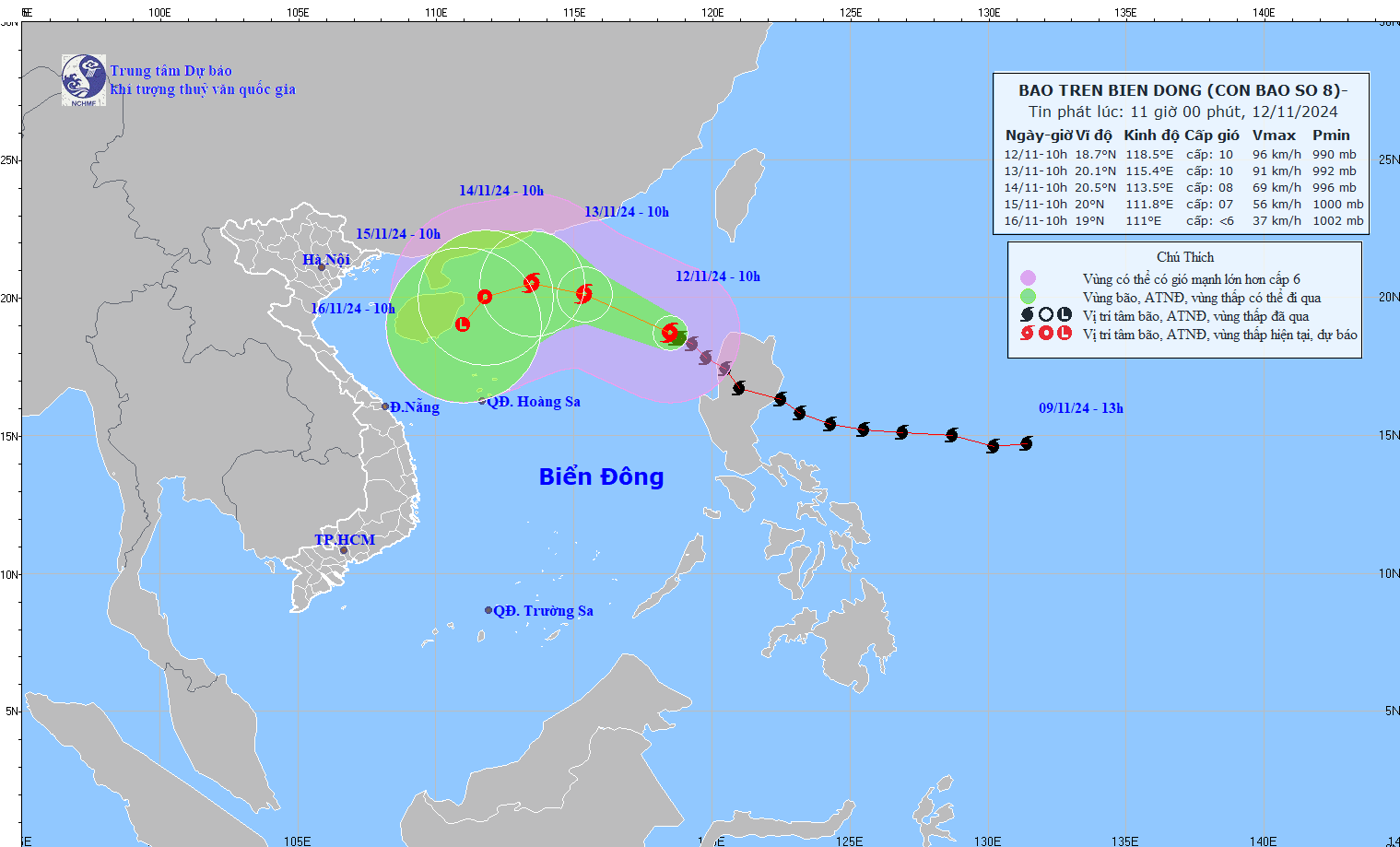
Latest storm news: Update on the direction and intensity of storm No. 8 in the East Sea. Photo: NCHMF
Forecast of storm No. 8 in the next 24 to 72 hours
Forecast time | Direction, speed | Location | Intensity | Danger zone | Disaster Risk Level (Affected Area) |
10h/13/11 | West Northwest, about 15km/h | 20.1N-115.4E; in the northern sea area of the North East Sea | Level 9-10, jerk level 12 | Latitude 16.5N-22.0N; East of longitude 113.5E | Level 3: Northern sea area of the North East Sea |
10h/14/11 | West Northwest, about 10km/h, intensity gradually weakens | 20.5N-113.5E; in the northwest sea of the North East Sea area | Level 8, level 10 jerk | Latitude 18.0N-22.0N; longitude 112.0E-116.5E | Level 3: Northern sea area of the North East Sea |
10h/15/11 | West Southwest, 5-10km/h and gradually weakens into a tropical depression | 20.0N-111.8E; on the northwest sea of the North East Sea area | Level 6-7, level 9 jerk | Latitude 18.0N-22.0N; longitude 110.5E-115.0E | Level 3: in the northwest sea area of the North East Sea |
From the next 72 to 96 hours, the tropical depression will move in the West Southwest direction, about 5km per hour, and its intensity will continue to weaken.
Regarding the impact of storm No. 8: The northern sea area of the North East Sea has strong winds of level 6-7, near the storm's eye level 8-10, gusts of level 12, waves 3.0-5.0m high, near the storm's eye 5.0-7.0m; very rough seas. Ships operating in the above-mentioned dangerous areas are likely to be affected by storms, whirlwinds, strong winds, and large waves.
Ready to respond to storm number 8
Meanwhile, storm No. 7 (Yinxing) has weakened into a tropical depression. On the morning of November 12, the center of the tropical depression was located at about 14.6 degrees North latitude - 109.7 degrees East longitude, over the sea of Quang Nam - Binh Dinh. The tropical depression is currently moving southwest at a speed of 15-20 km/hour.
According to the National Center for Hydro-Meteorological Forecasting, due to the influence of a tropical depression (weakened from storm No. 7) on Ly Son Island (Quang Ngai), there are strong winds of level 6, gusting to level 8. Last night and this morning (November 12), the area from Thua Thien Hue to Quang Ngai had moderate rain, heavy rain, and in some places very heavy rain, with total rainfall ranging from 30-70mm, locally over 100mm.
On the morning of November 12, Deputy Minister of Agriculture and Rural Development Nguyen Hoang Hiep signed and issued a telegram to relevant agencies, departments and People's Committees of coastal provinces and cities from Quang Ninh to Binh Dinh, requesting proactive response to storm No. 8.
According to the dispatch, first of all, it is necessary to closely monitor the storm's developments, strictly manage vehicles going out to sea, organize a count and promptly notify vehicle owners, ship captains and boats operating at sea of the location and direction of the storm so that they can proactively avoid it, leave dangerous areas or find safe shelter.
The Ministry of Agriculture and Rural Development warns that the dangerous area in the next 24 hours is determined from latitude 15.5 to 21.5 degrees North and east of longitude 114 (to be adjusted in the next bulletins).
The Ministry of Agriculture and Rural Development also noted that rescue forces need to be ready to participate in rescue operations when requested. Mass media and coastal radio stations should increase broadcasting of warning bulletins and update storm developments to authorities at all levels and owners of vessels operating at sea so that they can take precautions and respond promptly.
The dispatch emphasized that authorities at all levels and relevant agencies need to take response measures to minimize the impact of the storm on people and economic activities in coastal localities.
Source: https://danviet.vn/tin-bao-moi-nhat-cap-nhat-moi-nhat-ve-huong-di-cuong-do-cua-bao-so-8-tren-bien-dong-20241112110842381.htm
![[Photo] Sparkling lanterns to celebrate Vesak 2025](https://vphoto.vietnam.vn/thumb/1200x675/vietnam/resource/IMAGE/2025/5/7/a6c8ff3bef964a2f90c6fab80ae197c3)


![[Photo] Prime Minister Pham Minh Chinh chairs meeting to review preparations for trade negotiations with the United States](https://vphoto.vietnam.vn/thumb/1200x675/vietnam/resource/IMAGE/2025/5/6/1edc3a9bab5e48db95318758f019b99b)


![[Photo] Prime Minister Pham Minh Chinh receives Mr. Tomas Heidar, Chief Justice of the International Tribunal for the Law of the Sea (ITLOS)](https://vphoto.vietnam.vn/thumb/1200x675/vietnam/resource/IMAGE/2025/5/6/58ba7a6773444e17bd987187397e4a1b)


Comment (0)