
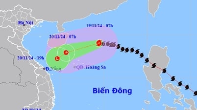
At 7 p.m., the center of the tropical depression was in the western sea of the North East Sea, about 180 km north of the Hoang Sa archipelago. The strongest wind near the center of the tropical depression was level 7 (50-61 km/h), gusting to level 9, moving southwest at a speed of about 20 km/h.
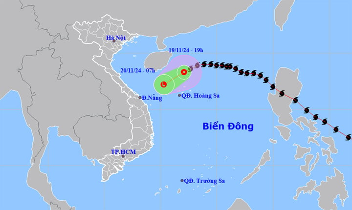
Tonight, November 19, storm No. 9 weakened into a tropical depression, about 180km from Hoang Sa archipelago. (Source: NCHMF)
Forecast in the next 24 hours, the tropical depression in the West of the North East Sea, moving in the Southwest direction, traveling about 20km per hour.
Due to the impact of the tropical depression, the western sea area of the North East Sea (including the sea area north of Hoang Sa archipelago) has strong winds of level 6-7, gusts of level 9, waves 3-5m high, and rough seas.
Regarding the weather forecast for the next 10 days in mainland Vietnam, the meteorological agency said that in the next 24 to 48 hours, the North, Thanh Hoa and Nghe An will have some rain. In particular, the Northeast will have no rain at night and sunny during the day. The night and early morning will be cold.
From Ha Tinh to Phu Yen, there will be rain and showers at night, with some places having heavy rain and thunderstorms. From November 20, this area will have scattered rain.
Other areas have showers and thunderstorms in the evening and at night, sunny during the day.
According to the weather forecast from the night of November 21 to November 29, the National Center for Hydro-Meteorological Forecasting said that the North, Thanh Hoa and Nghe An will have rain in some places. It will be cold at night and early morning.
From Ha Tinh to Binh Dinh there will be rain, showers, locally heavy rain and thunderstorms.
Other areas have scattered showers and thunderstorms. Thunderstorms can cause tornadoes, lightning and strong gusts of wind.
Source: https://vtcnews.vn/bao-so-9-suy-yeu-thanh-ap-thap-nhiet-doi-mien-trung-co-noi-mua-to-va-dong-ar908374.html
![[Photo] Prime Minister Pham Minh Chinh receives delegation from the US-China Economic and Security Review Commission of the US Congress](https://vphoto.vietnam.vn/thumb/1200x675/vietnam/resource/IMAGE/2025/5/7/ff6eff0ccbbd4b1796724cb05110feb0)


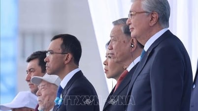
![[Photo] General Secretary attends the parade to celebrate the 80th anniversary of the victory over fascism in Kazakhstan](https://vphoto.vietnam.vn/thumb/1200x675/vietnam/resource/IMAGE/2025/5/7/dff91c3c47f74a2da459e316831988ad)


![[Photo] Sparkling lanterns to celebrate Vesak 2025](https://vphoto.vietnam.vn/thumb/1200x675/vietnam/resource/IMAGE/2025/5/7/a6c8ff3bef964a2f90c6fab80ae197c3)


Comment (0)