
Latest storm news: It is forecasted that tonight (November 11), when storm number 7 weakens, storm Toraji, which is active in the waters east of the Philippines, will enter the East Sea, becoming storm number 8.
Latest storm news update: Storm No. 7 will weaken into a tropical depression
At 1 p.m. on November 11, the center of the storm was located at approximately 16.5 degrees North latitude; 110.9 degrees East longitude, in the sea northwest of the Hoang Sa archipelago. The strongest wind near the center of the storm was level 8 (62-74 km/h), gusting to level 10. Moving southwest at a speed of 15-20 km/h.
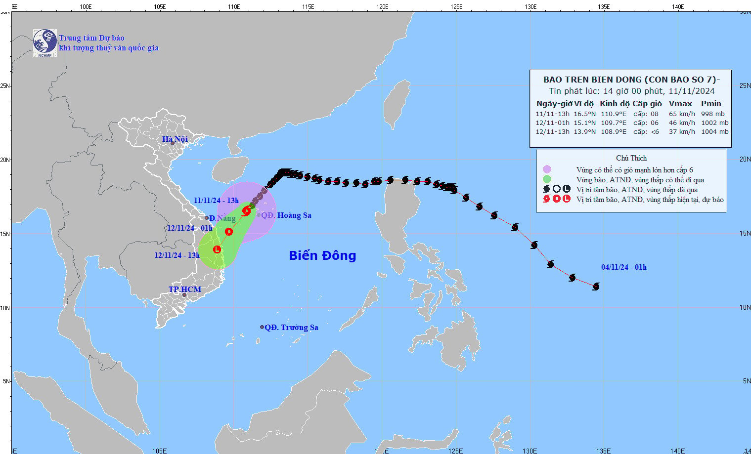
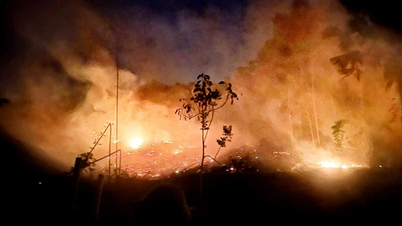
Latest storm news update: Storm No. 7 will weaken into a tropical depression. Photo: NCHMF
Forecast of storm No. 7 in the next 12 to 24 hours
| Forecast time | Direction, speed | Location | Intensity | Danger zone | Disaster Risk Level (Affected Area) |
| 01h/12/11 | Southwest, 15-20km/h, weakening into a tropical depression | 15.1N-109.7E; on the sea of Quang Nam-Binh Dinh | Level 6, level 8 jerk | Latitude 14.5N-18.5N; longitude 109.0E-113.0E | Level 3: Hoang Sa archipelago waters, offshore waters from Thua Thien Hue to Binh Dinh |
| 13h/12/11 | Southwest, about 15km/h, weakening into a low pressure area | 13.9N-108.9E; on land in Quang Ngai-Phu Yen provinces | Latitude 14.0N-16.5N; longitude 109.0E-111.0E | Level 3: offshore waters from Thua Thien Hue to Binh Dinh |
Regarding the impact of storm No. 7: The sea area of Hoang Sa archipelago has strong winds of level 6-7, the area near the storm's eye has level 8, gusts of level 10, waves 2.0-4.0m high, the area near the storm's eye has 3.0-5.0m; rough seas.
From the afternoon of November 11, the sea off the coast of Thua Thien Hue to Binh Dinh will have winds gradually increasing to level 6-7, gusting to level 9, waves 2.0-4.0m high; rough seas.
Ships operating in the above mentioned dangerous areas are likely to be affected by storms, whirlwinds, strong winds and large waves.
Tonight (November 11), storm Toraji will enter the East Sea and become storm number 8.
Update on the latest news about storm Toraji, at 13:00 on November 11, the center of the storm was at about 16.7 degrees North latitude; 121.0 degrees East longitude, in the middle of Luzon Island (Philippines). The strongest wind near the center of the storm is level 12 (118-133km/h), gusting to level 15. Moving in the West Northwest direction, speed about 20km/h.
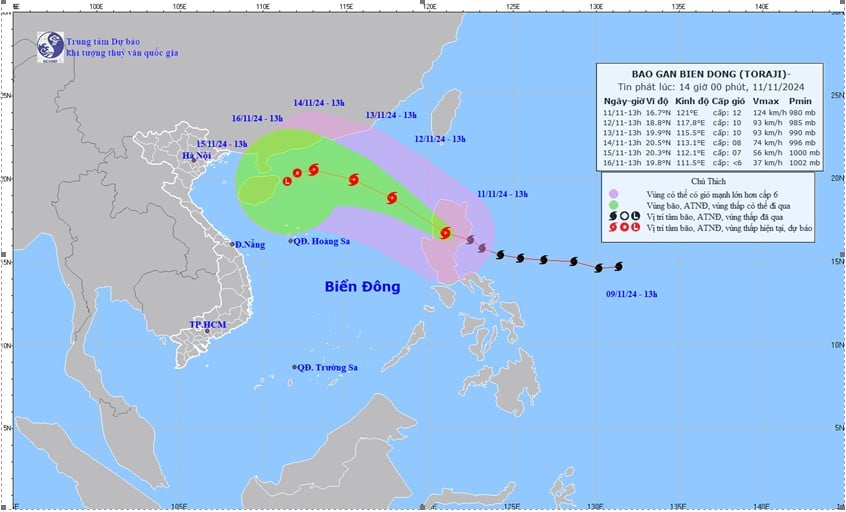
Latest storm news update: Tonight (November 11), storm Toraji will enter the East Sea and become storm number 8. Photo: NCHMF
Storm forecast (in the next 24 to 72 hours):
1:00 p.m., November 12: The storm moves in a West-Northwest direction at a speed of about 20 km/h, entering the East Sea. The center of the storm is located at about 18.8N-117.8E, in the sea area east of the North East Sea. Intensity level 10, gust level 12. Dangerous area: from latitude 15.0N to 20.5N and east of longitude 116.0E. Disaster risk level 3: Northeast of the East Sea.
From 1:00 p.m. on November 13: The storm continues to move west-northwest, with a speed reduced to 10-15 km/h. The center of the storm is located at approximately 19.9N-115.5E, in the eastern sea area of the North East Sea. The intensity remains at level 10, gusting to level 12. Dangerous area: from latitude 17.0N to 22.0N and east of longitude 113.5E. Disaster risk level 3: the North East Sea area.
From 1:00 p.m. on November 14: The storm moves in a West-Northwest direction at a speed of 10-15 km/h and shows signs of weakening. The center of the storm is located at about 20.5N-113.1E, north of the North East Sea. The intensity has decreased to level 8, gusting to level 10. Dangerous areas: from latitude 18.0N to 22.0N and from longitude 111.0E to 117.0E. Disaster risk level 3: north of the North East Sea.
Storm development warning (in the next 72 to 120 hours): From the next 72 to 120 hours, the storm is likely to move in the West Southwest direction at a speed of about 5 km/h, with the intensity continuing to weaken.
Regarding the impact of storm Toraji: The sea area east of the North East Sea will have winds gradually increasing to level 6-7, then increasing to level 8, near the storm center will have winds of level 9-10, gusting to level 12, waves 3.0-5.0m high, near the storm center 5.0-7.0m; very rough seas. Ships operating in the above-mentioned dangerous areas are likely to be affected by storms, whirlwinds, strong winds, and large waves.
Experts say that during the day and night of November 11, the North East Sea will have showers and thunderstorms, especially in the western sea (including the Hoang Sa sea); the sea from Quang Tri to Quang Ngai, Ca Mau to Kien Giang and the Gulf of Thailand will have scattered showers and thunderstorms; in the thunderstorms, there is a possibility of tornadoes and strong gusts of wind of level 7-8.
In addition, on the day and night of November 12, the sea area from Thua Thien - Hue to Binh Dinh has strong winds of level 5, sometimes level 6, gusts of level 7-8, waves 2-3 m high; rough seas; the wind gradually decreases at night. The sea area to the east of the North East Sea has strong winds of level 7-9, near the storm center it has level 10, gusts of level 12, waves 3-5 m high, near the storm center it has 5-7 m; the sea is very rough.
The risk of natural disasters due to strong winds at sea is level 2. Particularly in the western and eastern sea areas of the North East Sea (including Hoang Sa sea area), the offshore sea area from Thua Thien - Hue to Binh Dinh is level 3.
Source: https://danviet.vn/tin-bao-moi-nhat-bao-so-7-suy-yeu-dem-nay-11-11-bao-toraji-se-vao-bien-dong-tro-thanh-bao-so-8-20241111141912968.htm


![[Photo] Prime Minister Pham Minh Chinh receives Swedish Minister of International Development Cooperation and Foreign Trade](https://vphoto.vietnam.vn/thumb/1200x675/vietnam/resource/IMAGE/2025/5/12/ae50d0bb57584fd1bbe1cd77d9ad6d97)


![[Photo] Prime Minister Pham Minh Chinh works with the Standing Committee of Thai Binh Provincial Party Committee](https://vphoto.vietnam.vn/thumb/1200x675/vietnam/resource/IMAGE/2025/5/12/f514ab990c544e05a446f77bba59c7d1)


Comment (0)