
According to the National Center for Hydro-Meteorological Forecasting, around the morning of November 18, storm MANYI will move into the East Sea, becoming the 9th storm affecting our country during this year's storm and flood season.
Talking to Dan Viet about the latest storm news, storm MANYI, Mr. Nguyen Van Huong, Head of Weather Forecast Department, National Center for Hydro-Meteorological Forecasting said that this morning (November 16), storm MANYI has strengthened to level 16, gusting above level 17, a super storm.
The location of super typhoon MANYI at 7am this morning was at approximately 12.5 degrees North latitude; 126.7 degrees East longitude, in the sea east of the central Philippines.
The strongest wind near the center of the super typhoon is level 16 (184-201km/h), gusting over level 17, the storm moves in a West Northwest direction, speed 20-25km/h.
It is forecasted that in the next 24 hours, super typhoon MANYI will move mainly in the northwest direction at a speed of about 20-25km/h and maintain an intensity of level 16; by tomorrow afternoon (November 17), super typhoon MANYI will make landfall in the Luzon island area (Philippines) and gradually weaken. Around the morning of November 18, typhoon MANYI will move into the East Sea, becoming the 9th typhoon affecting our country during this year's storm and flood season.
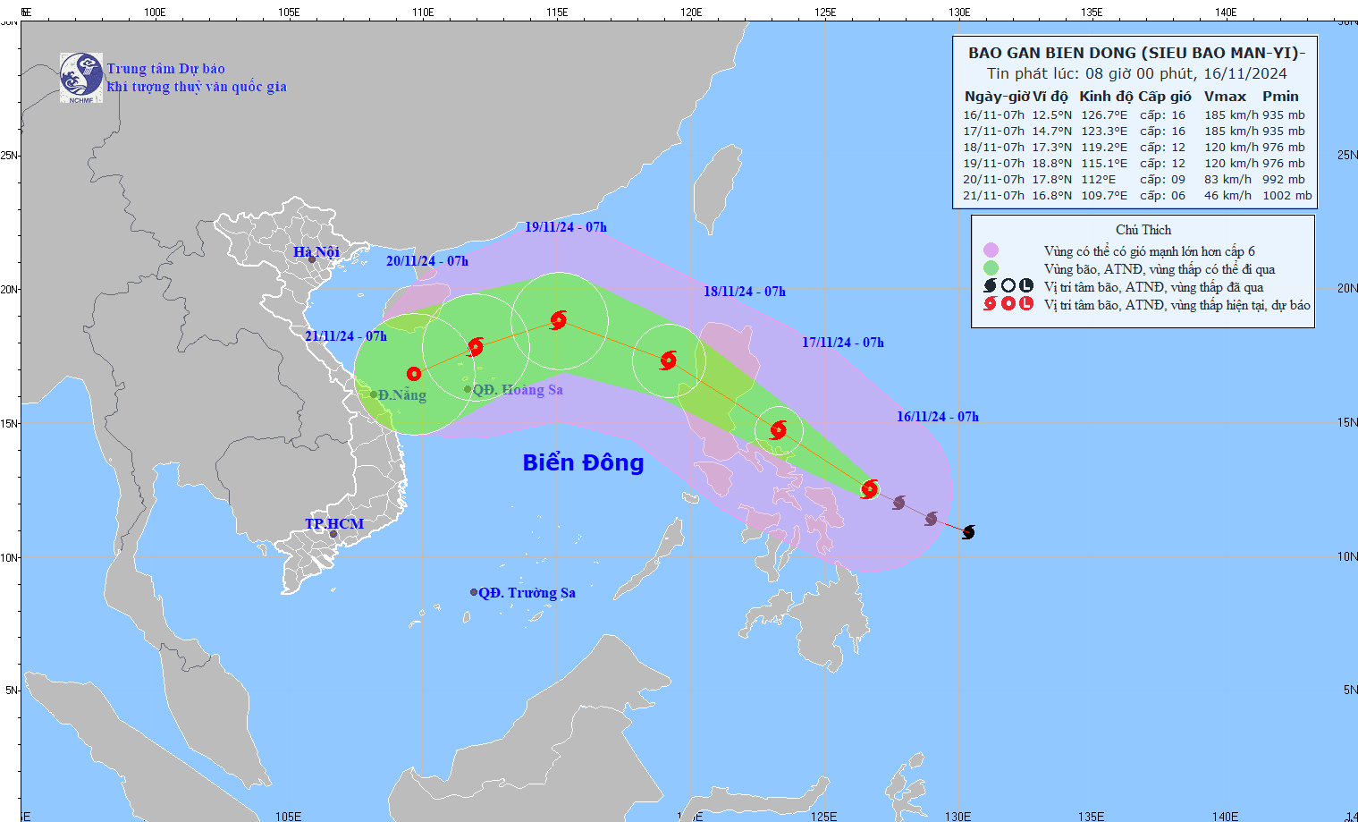
The movement of storm MANYI. Photo: nchmf
Mr. Nguyen Van Huong noted that the time when storm MANYI moves into the East Sea is also the time when the East Sea is affected by a strong cold air mass. The interaction between the cold air mass and storm MANYI will cause many changes in the intensity and direction of storm MANYI.
"The most important thing to note right now is that the interaction of cold air and storm MANYI will make the weather in the East Sea region very bad in the coming days, with strong winds, high waves and rough seas. The development of storm MANYI will still change a lot, so we need to closely monitor it," Mr. Huong emphasized.
Regarding the cold air situation, currently (November 16), in the North, a cold air mass is moving southward; around the afternoon and night of November 17, this cold air mass will affect the Northeast; then affect the North Central region, most places in the Northwest and some places in the Central Central region. The Northeast wind inland will strengthen to level 3, coastal areas level 4.
From November 18, in the Northeast and Thanh Hoa, the weather will turn cold at night and early morning; from November 20, in the North and North Central regions, the weather will be cold at night and early morning. The lowest temperature during this cold air mass in the North and North Central regions will generally be from 18-20 degrees Celsius, in mountainous areas, some places will be below 15 degrees Celsius.
Source: https://danviet.vn/tin-bao-moi-nhat-bao-manyi-da-manh-len-thanh-sieu-bao-ngay-18-11-du-kien-se-vao-bien-dong-20241116094154301.htm

![[Photo] Ready for the top competitions of Vietnamese table tennis](https://vphoto.vietnam.vn/thumb/1200x675/vietnam/resource/IMAGE/2025/5/18/9c547c497c5a4ade8f98c8e7d44f5a41)


![[Photo] Many young people patiently lined up under the hot sun to receive a special supplement from Nhan Dan Newspaper.](https://vphoto.vietnam.vn/thumb/1200x675/vietnam/resource/IMAGE/2025/5/18/6f19d322f9364f0ebb6fbfe9377842d3)
![[Photo] Party and State leaders attend the special art program "You are Ho Chi Minh"](https://vphoto.vietnam.vn/thumb/1200x675/vietnam/resource/IMAGE/2025/5/18/6895913f94fd4c51aa4564ab14c3f250)


Comment (0)