
Tropical depression (possibly later storm) is forecast to cause heavy rain in the North Central and Central Central provinces, warning of flash floods and landslides in mountainous areas from Ha Tinh to Quang Nam.
Location and direction of tropical depression at 10am September 18 – Photo: NCHMF
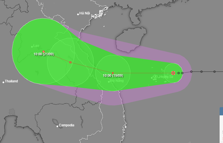
According to the National Center for Hydro-Meteorological Forecasting at 12 noon on September 18, the center of the tropical depression was about 160km east of Vietnam's Hoang Sa archipelago, the strongest wind near the center of the tropical depression was level 7 (50-61km/h), gusting to level 9.
Mr. Nguyen Van Huong, head of the weather forecast department, National Center for Hydro-Meteorological Forecasting, said that in the next 24 hours, the tropical depression is forecast to mainly move westward. When it moves to Hoang Sa archipelago, it is likely to strengthen into a storm.
"After strengthening into a storm, the storm changed direction and moved west-northwest and towards the mainland of the central provinces," said Mr. Huong.
According to Mr. Huong, due to the impact of the tropical low pressure circulation (later a storm), today and tonight in the North East Sea there will be strong winds of level 6-7, near the storm center level 8. From around tomorrow morning (September 19), the sea area from Ha Tinh to Quang Nam, Quang Ngai will have strong winds of level 6-7, near the storm center level 8, level 9, waves from 2-4m high, near the storm center 3-5m.
Ships operating in the above mentioned dangerous areas are likely to be affected by storms, whirlwinds, strong winds and large waves.
The meteorological agency also warned coastal provinces from Quang Binh to Quang Nam to be on guard against rising water due to strong winds of 0.3-0.5m high, combined with high tides and big waves causing landslides of sea dykes and embankments, and flooding in low-lying areas.
For the mainland, from early morning and September 19, coastal mainland areas from Ha Tinh to Quang Ngai will have winds gradually increasing to level 6-7, areas near the storm's center will have winds of level 8 (62-74km/h), gusting to level 10 (89-102km/h), and deep inland will have winds of level 6-7.
Regarding rain, Mr. Huong said that due to the impact of the tropical convergence zone passing through the Central region combined with the front circulation of the tropical depression, last night and early this morning in the North Central and Central Central regions there was heavy rain with common rainfall from 30-70mm, in some places approximately 100mm.
“It is forecasted that from today until the morning of September 20, heavy rain will occur in the North Central and Central Central regions, with common rainfall of 100-300mm, and in some places over 500mm.
With such rainfall, mountainous areas of Ha Tinh, Quang Binh, Quang Tri, Thua Thien Hue, and Quang Nam need to pay close attention to flash floods and landslides," Mr. Huong warned.
Tuoitre.vn
Source: https://tuoitre.vn/ap-thap-nhiet-doi-gay-mua-rat-lon-canh-bao-lu-quet-sat-lo-dat-o-5-tinh-mien-trung-20240918112306239.htm

![[Photo] Prime Minister Pham Minh Chinh chairs conference on anti-smuggling, trade fraud, and counterfeit goods](https://vphoto.vietnam.vn/thumb/1200x675/vietnam/resource/IMAGE/2025/5/14/6cd67667e99e4248b7d4f587fd21e37c)


Comment (0)