According to the assessment of the Department of Dyke Management and Natural Disaster Prevention and Control (Ministry of Agriculture and Rural Development), storm Yagi (storm No. 3) is a strong, abnormal storm with great destructive power and unprecedented characteristics such as: storm intensity increases very quickly (in 48 hours, storm intensity increases by 8 levels), when making landfall in the Quang Ninh - Hai Phong area, the wind in the storm center is strong at level 13 - level 14, gusting at level 16 - level 17.
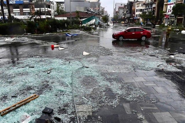
Storm Yagi (storm number 3) leaves Quang Ninh devastated
In addition, this storm maintained super typhoon level for a long time and was the strongest storm in 30 years in the East Sea and in the past 70 years on the Vietnamese mainland; the storm's stay on land lasted 12 hours.
In particular, the storm circulation caused heavy rain throughout the North and Thanh Hoa (26 provinces and cities), in which 83/84 rainfall measuring stations had rainfall 4-6 times higher than the average of many years in the first 10 days of September (some places had rain over 700 mm).
Due to heavy rain, the Northern region experienced major floods, especially large-scale floods (most rivers exceeded alert level 3), including historic floods on 7 rivers (Thao River, Day River, Cau River, Ninh Co River, Kinh Mon River, Gua River, Tra Ly River). In Hanoi, the water level of the Red River was also recorded at its highest level in the past 20 years.
Prolonged heavy rains caused landslides, flash floods and landslides in most mountainous and midland provinces in the North, especially Lao Cai, Yen Bai, Cao Bang, etc.
Wind gusts never before seen in Vietnam
In addition to the above abnormal characteristics, the National Center for Hydro-Meteorological Forecasting also said that when Typhoon Yagi made landfall, the storm's center was at level 13-14, gusting to level 17. The wind gusting to level 17 (the highest wind level in the storm forecast) on land has never happened in the history of Vietnam. These are limitations that the meteorological agency "has not calculated or forecasted".
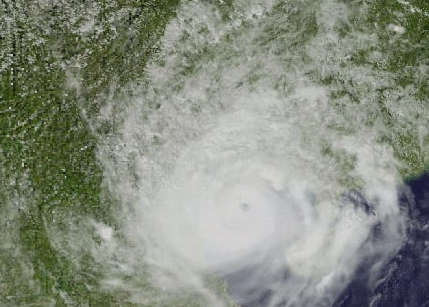
When on the coast of Quang Ninh - Hai Phong, the eye of storm Yagi is still sharp, the circulation is beautiful and symmetrical.
In addition to wind level 17, this agency has not yet forecasted heavy rain intensity of over 200 mm/6 hours. Current calculation information has not yet determined the intensity of heavy rain in a short period of time and localized the concentrated rainfall in the Thao and Lo river basins; has not yet calculated and forecasted early the historical flood rising rapidly with high intensity at some locations on the Thao river and has not yet warned in detail to villages, hamlets, flash flood and landslide points.
According to the National Center for Hydro-Meteorological Forecasting, the difficulties and limitations in forecasting are due to the geological terrain characteristics of the northern midland and mountainous region, which are strongly fragmented and have complex spatial fluctuations. In addition, there are many unusual factors regarding the development of storm No. 3 and the nature of rain and floods.
Notably, the technology for monitoring and forecasting natural disasters (storms, rain, floods, flash floods, landslides) has reached the level of countries in the region, but is still limited in assessing and forecasting extreme and unusual values. In particular, forecasting and warning of flash floods and landslides in detail down to each village and hamlet is currently very difficult and scientifically limited, even in developed countries (even when there is a sufficiently dense system of rain monitoring and ground movement monitoring).
In addition, the inter-reservoir operation process also has many unreasonable points in extreme flood situations.
Forecasting solutions to respond to natural disasters
Regarding solutions, the meteorological agency said it is necessary to upgrade and innovate the warning system such as applying advanced technologies such as artificial intelligence and machine learning to improve the accuracy of disaster forecasting models, especially for floods, storms and landslides.
In particular, promote the addition of automatic monitoring stations with the latest generation of monitoring technologies in vulnerable areas, ensuring accurate and timely data collection. Build a disaster warning information system to serve the direction and implementation of response methods according to the level of natural disaster risks, connecting with the Government, ministries, branches and localities.
Develop education and communication programs on climate change and natural disaster risks to raise people's awareness of measures to prevent and protect themselves from natural disasters.
Continue to implement tasks under the project on Early Warning of Landslides and Flash Floods in the Mountainous and Midland Areas of Vietnam in Decision No. 1262/QD-TTg dated October 27, 2023 of the Prime Minister.
Review local planning and strategies including infrastructure planning, land use planning, residential planning, and disaster prevention planning, especially in areas heavily affected by the recent storm.
Thanhnien.vn
Source: https://thanhnien.vn/them-ky-luc-chua-tung-xay-ra-o-viet-nam-cua-bao-yagi-185240929073226956.htm


![[Photo] Russian military power on display at parade celebrating 80 years of victory over fascism](https://vphoto.vietnam.vn/thumb/1200x675/vietnam/resource/IMAGE/2025/5/9/ce054c3a71b74b1da3be310973aebcfd)
![[Photo] General Secretary To Lam and international leaders attend the parade celebrating the 80th anniversary of the victory over fascism in Russia](https://vphoto.vietnam.vn/thumb/1200x675/vietnam/resource/IMAGE/2025/5/9/4ec77ed7629a45c79d6e8aa952f20dd3)
![[Photo] Prime Minister Pham Minh Chinh chairs a special Government meeting on the arrangement of administrative units at all levels.](https://vphoto.vietnam.vn/thumb/1200x675/vietnam/resource/IMAGE/2025/5/9/6a22e6a997424870abfb39817bb9bb6c)
![[Photo] Magical moment of double five-colored clouds on Ba Den mountain on the day of the Buddha's relic procession](https://vphoto.vietnam.vn/thumb/1200x675/vietnam/resource/IMAGE/2025/5/9/7a710556965c413397f9e38ac9708d2f)





















Comment (0)