
Scientists have found a giant mountain under the Pacific Ocean that is about 1,600 meters high, twice as tall as the Burj Khalifa, the world's tallest building.
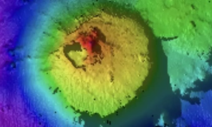
1,600 m high underwater mountain at the bottom of the Pacific Ocean. Photo: SOI
The seamount rises 1,600 meters above the seabed and lies about 4,000 meters below sea level. Experts discovered it during an expedition conducted by the Schmidt Ocean Institute (SOI) in international waters, 135 kilometers from Guatemala's exclusive economic zone.
Seamounts are underwater mountains with steep slopes that rise from the ocean floor, according to the National Oceanic and Atmospheric Administration (NOAA). Most are the remains of extinct volcanoes and are usually conical in shape. Seamounts are found in every ocean basin in the world, but experts are unsure of their exact number. The number of seamounts that are at least 1,000 meters (3,200 feet) high is thought to be more than 100,000, but scientists have only discovered a fraction of them so far.
The new seamount was observed by the SOI expedition using the EM124 Multibeam Echo Sounder on the research vessel Falkor (too). This instrument is capable of mapping the seafloor with high resolution.
After the echosounder detected the seamount, an expert on board confirmed that the structure was not in any seafloor database. The data showed that the mountain covered an area of more than 13 square kilometers. "The fact that a seamount over 1.5 kilometers high has remained hidden beneath the waves until now shows that there is still a lot that we have yet to discover," said Jyotika Virmani, executive director of SOI.
Seamounts are biodiversity hotspots, providing a surface for organisms such as deep-sea corals, sponges, and many invertebrates to settle and grow. These organisms, in turn, provide food for other animals. Seamount ecosystems are often home to unique species found in only one location. Mapping and exploring these unknown areas of the ocean floor is key to scientists’ understanding of Earth.
SOI is a partner in the Seabed 2030 program, which aims to map the entire seabed by 2030. Currently, the lack of detailed maps of much of the seabed makes it difficult to navigate safely, manage marine resources sustainably, and protect coastal communities.
Thu Thao (According to Newsweek )
Source link

![[Photo] The moment Harry Kane lifted the Bundesliga trophy for the first time](https://vphoto.vietnam.vn/thumb/1200x675/vietnam/resource/IMAGE/2025/5/11/68e4a433c079457b9e84dd4b9fa694fe)


![[Video] Bringing environmental technology from the lab to life](https://vphoto.vietnam.vn/thumb/402x226/vietnam/resource/IMAGE/2025/5/11/57d930abeb6d4bfb93659e2cb6e22caf)
![[Video] Product risk classification: Solution to reform quality management, reduce burden for businesses](https://vphoto.vietnam.vn/thumb/402x226/vietnam/resource/IMAGE/2025/5/11/cbcd6b50805549a5bbb9e8e6354eda70)
![[Video] Domain name “.vn” - National symbol in cyberspace](https://vphoto.vietnam.vn/thumb/402x226/vietnam/resource/IMAGE/2025/5/11/ff459b2b640347a5948e3424e5c256d0)


Comment (0)