
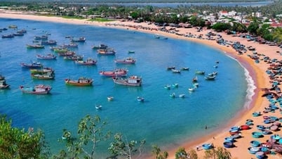
We went to Yen Luong hamlet, Chau Quang commune, and saw some houses of the people lying precariously along the Nam Huong river bank, the landslide had eaten deep into the front yard. Mr. Lu Van Ly, in Yen Luong hamlet, said: The flood in 2022 swept the pig pen and cow pen into the Nam Huong river. The flood just over a month ago had eaten right into the kitchen area. At this rate, in just a short time, the river will encroach on the whole house.

An elderly person in Yen Luong hamlet shared: “I have never seen the river erode as strongly as it does now. This year, after heavy rains, the red river water swirled and caused the landslide to become stronger, threatening people’s homes. This area has eroded, losing land, but I have never seen the river add another meter.”
Walking along the Nam Huong River, we saw that the riverbanks were even "eating" into the acacia hills, and the people's sugarcane fields were also washed away by the river. Mr. Tran Minh - a resident of Chau Quang commune led us to the eroded sugarcane fields, and said sadly: The sugarcane is almost ready for harvest, but many areas are already under the river, people have lost both their production land and their income. We only hope that the authorities will soon take remedial measures to ensure the lives and property of the people.
According to research, most of the people living in landslide areas still have poor lives. Many households have had their production and residential land "swallowed" by the river and have had to work as stone and tin miners, making their lives even more miserable.

Mr. Pham Cong Truyen - Chairman of Chau Quang Commune People's Committee added: Nam Huong River originates from Chau Thanh and Chau Hong communes and flows into Dinh River, passing through the commune for more than 3 km. The floods caused landslides on the riverbank with a length of over 1 km, affecting 30 households in Yen Luong hamlet. Due to the landslides on Nam Huong Riverbank, over 8 hectares of cultivated land and alluvial land were washed away into the river.
To deal with the landslides, in recent years, the People's Committee of the commune has mobilized people to plant bamboo, drive bamboo stakes, and temporarily embank some severely eroded areas with stone but it has not worked, every flood season everything flows down the river.
The commune has reported the landslide to higher authorities, the district has also come to grasp the situation but so far there have been no specific measures, the commune can only advise people to be aware of protecting their lives and property.

Below is Tam Hop commune, which has also been severely affected by landslides over the years. A representative of Tam Hop commune People's Committee said: "The Dinh River section through the commune has been eroded for about 2.5 km, with 154 households at risk of landslides; of which, there are more than 40 households located in particularly dangerous areas, mainly in Tan Mung, Dinh, Dong Chao, Soi Duoi hamlets... In addition to the damage to land and property of the people, the Dinh River has damaged Provincial Road 532 for more than 2 km.
In recent years, Tam Hop commune has reported the landslide situation to the District People's Committee, and the District People's Committee has also set up inspection and survey teams. However, for many years, the relevant agencies have not had solutions to prevent landslides.

Mr. Nguyen Duy Hung - Head of the Department of Agriculture and Rural Development of Quy Hop district said: The situation of landslides on the banks of Dinh river, Nam Ton river, Nam Huong river passing through Chau Quang, Tho Hop, Tam Hop communes... in recent years has been complicated, causing a lot of damage to property as well as affecting people's lives. Riverbank landslides have swept away ancillary works of people's houses, lost cultivated land and residential land.
Currently, the entire district has only built one embankment at Le village, Chau Quang commune, with a length of over 400 meters. To ensure the safety of the people, during the rainy and stormy season, the district directs the communes to send forces, keep watch, grasp the situation and have plans to evacuate households in the riverbank landslide area when necessary.
During the rainy season, people living in communes near the mouth of the "river god" in Quy Hop district are worried about the water flowing from upstream. The Nam Huong and Dinh rivers writhe and change their course. Residential land and cultivated land with corn, sugarcane, beans, peanuts... are being swallowed by the ferocious river.
Source


![[Photo] Prime Minister Pham Minh Chinh starts construction of vital highway through Thai Binh and Nam Dinh](https://vphoto.vietnam.vn/thumb/1200x675/vietnam/resource/IMAGE/2025/5/12/52d98584ccea4c8dbf7c7f7484433af5)
![[Photo] Buddha's Birthday 2025: Honoring the message of love, wisdom, and tolerance](https://vphoto.vietnam.vn/thumb/1200x675/vietnam/resource/IMAGE/2025/5/12/8cd2a70beb264374b41fc5d36add6c3d)


Comment (0)