
While storm No. 7 is still 330km from the Paracel Islands, in the East of the Philippines, two storms named TORAJI and MAN-YI have appeared. Around tomorrow night (November 11), storm TORAJI will enter the East Sea.
Update latest news on storm number 7
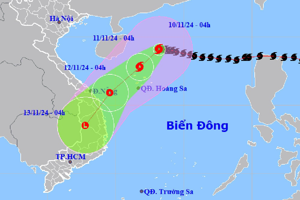
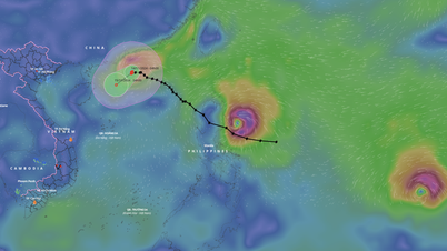
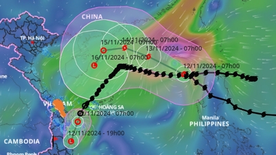
Update on the latest storm No. 7, according to the National Center for Hydro-Meteorological Forecasting, at 7:00 a.m. (November 10), the center of the storm was located at about 19.0 degrees North latitude; 113.2 degrees East longitude, in the northwest sea of the North East Sea, about 330km North-Northeast of Hoang Sa archipelago. The strongest wind near the center of the storm is level 13 (134-149km/h), gusting to level 16. Moving in the West-Southwest direction, speed about 5km/h.
Direction of movement of storm number 7. Photo: nchmf.
Forecast of storm number 7:
| Forecast time | Direction, speed | Location | Intensity | Danger zone | Disaster Risk Level (Affected Area) |
| 07:00/11/11 | Southwest, about 10km/h and weakening | 17.4N-111.4E; in the sea north-northwest of Hoang Sa archipelago | Level 9-10, jerk level 13 | Latitude 15.5N-21.0N; longitude 109.5E-115.0E | Level 3: Western sea area of the North East Sea (including the sea area of Hoang Sa archipelago) |
| 07:00/12/11 | Southwest, 10-15km/h, weakening into a tropical depression | 15.6N-109.3E; on the sea from Quang Tri to Quang Ngai | Level 6, level 8 jerk | Latitude 14.5N-19.5N; longitude 108.5E-113.5E | Level 3: Western sea area of the North East Sea (including Hoang Sa archipelago sea area), sea area from Quang Tri to Quang Ngai |
| 19h/12/11 | Southwest, about 15km/h, weakening into a low pressure area | 14.1N-108.3E; in the Central Highlands region |
Forecasting the impact of storm No. 7
The western sea area of the North East Sea has strong winds of level 7-9, near the storm center, level 10-13, gusts of level 16, waves 4.0-6.0m high, near the center, 6.0-8.0m; rough seas.
From early morning on November 11, the sea area from Quang Tri to Quang Ngai has strong winds of level 6-7, near the storm's eye it has strong winds of level 8, gusts of level 10, waves 2.0-4.0m high, near the storm's eye 3.0-5.0m high; rough seas.
Ships operating in the above mentioned dangerous areas are likely to be affected by storms, whirlwinds, strong winds and large waves.
Update new storm news, storm TORAJI
Currently in the East of the Philippines there are 2 storms TORAJI and MAN-YI. Around tomorrow night (November 11), storm TORAJI will enter the East Sea.
Among them, the storm with the international name TORAJI is active in the sea east of Luzon Island (Philippines).
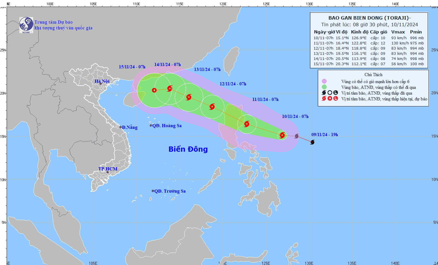
At 7:00 a.m. on November 10, the center of the storm was located at approximately 15.1 degrees North latitude; 126.9 degrees East longitude, in the sea northeast of Luzon Island. The strongest wind near the center of the storm was level 10 (89-102 km/h), gusting to level 12. Moving in the West Northwest direction, speed 15-20 km/h.
Forecast of storm TORAJI ( next 24 to 72 hours):
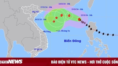
The movement of storm TORAJI. Photo: nchmf.
Forecast time | Direction, speed | Location | Intensity | Danger zone | Disaster Risk Level (Affected Area) |
07:00/11/11 | West Northwest, about 20km/h | 16.4N-122.8E; in the sea east of Luzon Island (Philippines) | Level 12, jerk level 15 | Latitude 16.5N-21.0N; East of longitude 119.0E | |
07:00/12/11 | West Northwest, about 20km/h, entering the East Sea and gradually weakening | 18.4N-118.8E; in the eastern sea of the North East Sea area | Level 9, jerk level 11 | Latitude 15.0N-21.0N; East of longitude 117.5E | Level 3: East of the North East Sea area |
07:00/13/11 | West Northwest, about 15km/h | 19.5N-116.1E; in the North East Sea area, about 500km east of Hainan Island (China) | Level 9, jerk level 11 | Latitude 16.5N-21.5N; East of longitude 114.5E | Level 3: East of the North East Sea area |
From the next 72 to 120 hours, the storm will move in the West Northwest direction and then possibly change to the West Southwest direction, traveling 10-15km per hour, and its intensity will continue to weaken.
Warning of the impact of storm TORAJI
From the night of November 10, the eastern sea area of the North East Sea will have strong winds of level 6-7, near the storm's eye level 8-9, gusting to level 11, waves 2.0-4.0m high, near the eye 4.0-6.0m; very rough seas.
Ships operating in the above mentioned dangerous areas are likely to be affected by storms, whirlwinds, strong winds and large waves.
Source: https://danviet.vn/tin-bao-moi-nhat-bao-so-7-con-chua-tan-lai-xuat-hien-2-con-bao-moi-mot-con-ngay-mai-vao-bien-dong-20241110085311619.htm
![[Photo] Prime Minister Pham Minh Chinh chairs conference on anti-smuggling, trade fraud, and counterfeit goods](https://vphoto.vietnam.vn/thumb/1200x675/vietnam/resource/IMAGE/2025/5/14/6cd67667e99e4248b7d4f587fd21e37c)


Comment (0)