
According to the National Center for Hydro-Meteorological Forecasting, at 10:00 a.m. on September 4, the center of the storm was located at about 19.0 degrees North latitude; 117.5 degrees East longitude, in the eastern sea area of the North East Sea, about 730 km east of Hainan Island (China). The strongest wind near the center of the storm was level 12 (118-133 km/h), gusting to level 15, moving in a West Northwest direction, about 10 km/h.
Forecast of storm developments (in the next 24 to 72 hours) is as follows:
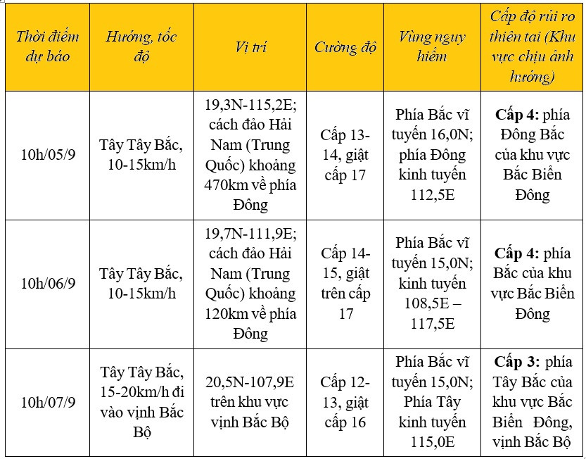
From the next 72 to 120 hours, the storm will move mainly in the West Northwest direction, traveling 15-20km per hour, and its intensity will continue to decrease.
Due to the influence of storm No. 3, Phu Quy island has strong winds of level 5, sometimes level 6, gusting to level 8; the eastern sea area of the North East Sea has storms; the central East Sea area, the sea area from Ca Mau to Kien Giang and the Gulf of Thailand have showers and thunderstorms.
Today and tonight, in the eastern sea of the North East Sea, there will be storms; in the central and southern East Sea (including the waters of the Truong Sa archipelago), the waters from Binh Thuan to Ca Mau, Ca Mau to Kien Giang and the Gulf of Thailand, there will be showers and thunderstorms. During the thunderstorms, there is a possibility of tornadoes and strong gusts of wind of level 7-9, with waves of 1.5-2.5m high.
The Meteorological Agency warns: Tomorrow (September 5) day and night, the North East Sea (including the waters of the Hoang Sa archipelago) will have strong winds of level 10-12, near the storm center strong winds of level 13-14, gusting to level 17; rough seas; waves may increase to 9-11m.
The Central and Southern East Sea (including the Truong Sa archipelago), the sea from Ninh Thuan to Ca Mau has strong southwest winds of level 6, sometimes level 7, gusting to level 8-9; rough seas; waves 3-5m high.
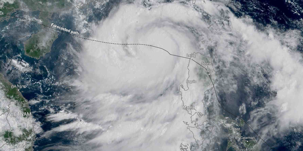
According to the latest storm forecast on September 4 of the Joint Typhoon Warning Center (JTWC) of the US Air Force and Navy, Typhoon Yagi is moving in the East Sea and the current environment is very favorable for the storm to strengthen.
The storm is expected to make landfall on China's Hainan Island, then pass through the Hainan Strait and enter the northern region of the Gulf of Tonkin.
The JWTC forecasts Typhoon Yagi’s next landfall near Hai Phong, Vietnam. The storm will then move rapidly inland, approaching the Lao border.
Source: https://vietnamnet.vn/bao-so-3-yagi-long-lon-o-bac-bien-dong-dao-phu-quy-gio-giat-cap-8-2318276.html
![[Photo] Prime Minister Pham Minh Chinh chairs the regular Government meeting in April 2025](https://vphoto.vietnam.vn/thumb/1200x675/vietnam/resource/IMAGE/2025/5/6/48eb0c5318914cc49ff858e81c924e65)


![[Photo] Overseas Vietnamese in France review history through special supplement commemorating 50 years of national reunification](https://vphoto.vietnam.vn/thumb/1200x675/vietnam/resource/IMAGE/2025/5/6/e92838061d514fceb6edc82f751aafef)


Comment (0)