
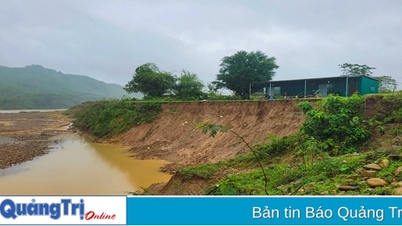
According to the 7am news (September 13) of Ninh Binh Hydrometeorological Station, the water level on Hoang Long River at Ben De has decreased to 4.82m; it is forecasted that in the next 12 hours it will change slowly in a downward trend but will still remain high.

Water on Hoang Long River at Dong Chua wharf (Gia Thinh commune, Gia Vien). Photo: Ngoc Linh
Previously, on the evening of September 12, the water level at Ben De peaked at 4.93m, 0.93m above alert level 3; at Gian Khau peaked at 4.53m, 0.83m above alert level 3, 0.03m higher than the historical flood peak in 2017 (4.50m); Day River in Ninh Binh peaked at 4.21m, 0.71m above alert level 3, 0.27m higher than the historical flood peak in 2017 (3.94m).
Water levels at 7:00 a.m. on September 13 on the rivers were as follows: On Hoang Long River at Ben De 4.82m, above alert level 3: 0.82m; at Gian Khau 4.43m, above alert level 3: 0.73m, lower than the historical flood peak in 2017 (4.50m): 0.07m; On Day River at Ninh Binh 4.07m, above alert level 3: 0.57m, above the historical flood peak in 2017 (3.94m) 0.13m.
Forecast for the next 12 hours: Water level on Hoang Long River at Ben De and Gian Khau will change slowly with a downward trend but will remain high. Water level on Day River in Ninh Binh will change slowly, be affected by tides and fluctuate at a high level.
In the next 12-24 hours: Water level on Hoang Long River at Ben De and Gian Khau will change slowly with a downward trend but will remain high. Water level on Day River in Ninh Binh will change slowly, affected by tides and will fluctuate at a high level.
Rising river water levels combined with heavy rains have caused widespread flooding in the riverbanks and communes of Gia Tien, Gia Hung, Gia Thinh, Gia Phong, Gia Hoa; 2 schools in Kenh Ga hamlet, Gia Thinh commune (outside the dike) of Gia Vien district; low-lying residential areas in the communes of Xich Tho, Gia Thuy, Lac Van, Gia Lam, Dong Phong, Gia Son, Thuong Hoa, Son Thanh (Nho Quan); Truong Yen commune (Hoa Lu); Yen Lam, Yen Thai, Khanh Duong communes, Yen Thinh town (Yen Mo); Khanh Van commune (Yen Khanh); Huu Day dike slope collapse in Hung Tien commune (Kim Son); low-lying, low-lying, riverside areas in Ninh Binh city, coastal estuaries of Kim Son district. There is a high risk of flash floods and landslides in mountainous areas, steep slopes, communes in Nho Quan, Hoa Lu districts, Tam Diep city, Yen Mo, Gia Vien.
Flood risk warning level: Level 3
Warning of flood impacts: High flood in the river poses a high risk of causing flash floods, landslides in mountainous areas, widespread flooding in riverside areas, mid-river flats, low-lying areas, affecting the safety of dykes, agricultural production, aquaculture and many local residential areas; can endanger people's lives and production, threaten people's lives and property and socio-economic activities.
Ninh Binh Newspaper
Source: https://baoninhbinh.org.vn/7h-ngay-13-9-muc-nuoc-tren-song-hoang-long-tai-ben-de-giam/d20240913074614680.htm
![[Photo] Party and State leaders attend the special art program "You are Ho Chi Minh"](https://vphoto.vietnam.vn/thumb/1200x675/vietnam/resource/IMAGE/2025/5/18/6895913f94fd4c51aa4564ab14c3f250)


![[Photo] Ready for the top competitions of Vietnamese table tennis](https://vphoto.vietnam.vn/thumb/1200x675/vietnam/resource/IMAGE/2025/5/18/9c547c497c5a4ade8f98c8e7d44f5a41)
![[Photo] Many young people patiently lined up under the hot sun to receive a special supplement from Nhan Dan Newspaper.](https://vphoto.vietnam.vn/thumb/1200x675/vietnam/resource/IMAGE/2025/5/18/6f19d322f9364f0ebb6fbfe9377842d3)


![[Infographic] Numbers about the 2025 High School Graduation Exam in Dong Thap Province](https://vphoto.vietnam.vn/thumb/402x226/vietnam/resource/IMAGE/2025/5/17/c6e481df97c94ff28d740cc2f26ebbdc)


Comment (0)