
Dakrong district, Quang Tri province has Dakrong river and Ba Long river flowing through. Every year in the rainy season, the water level on the rivers rises suddenly and flows rapidly, causing increasingly serious riverbank erosion, affecting people's lives and production.
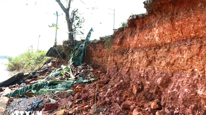
Through actual records along the Dakrong river bank, through Dong Dong village, Mo O commune, the reporter saw a landslide point that went deep into the mainland, about 30 meters long and about 5 meters deep.
According to local people, sand and gravel mining has caused riverbank erosion, affecting their productive land. Therefore, through meetings with voters, people have petitioned the competent authorities to consider investing in building a riverbank embankment system so that they can live and work in peace.
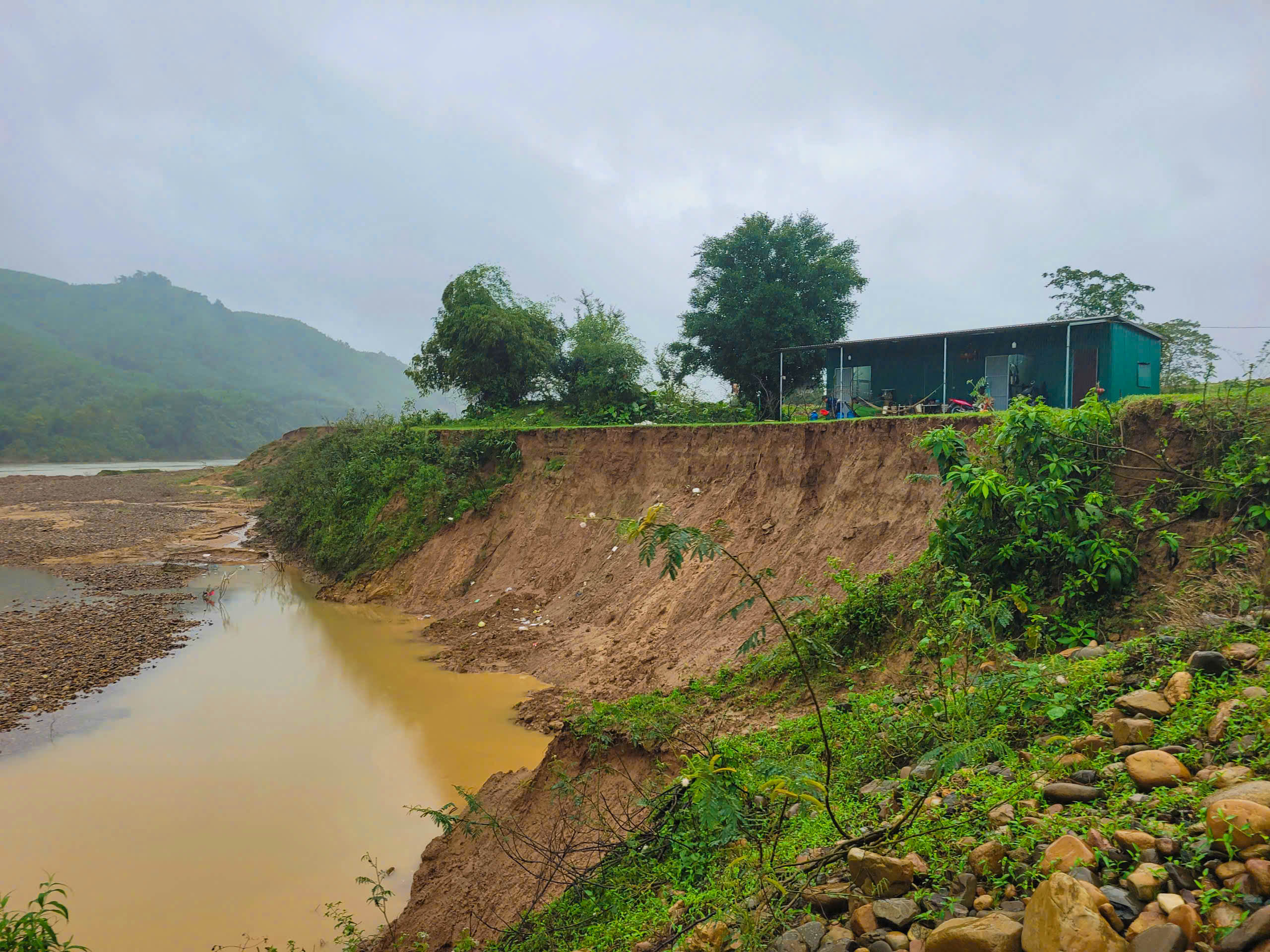
A landslide on the riverbank in Dong Duong village, Mo O commune - Photo: Tran Tuyen
According to the report of the Department of Agriculture and Rural Development of Dakrong district, in recent years, there have been 4 landslides on both sides of Dakrong river and Ba Long river with a total length of about 2.8 km. In particular, in A Ngo village, A Ngo commune, the landslide has been occurring since 2012. The landslide length is determined to be about 1 km, 30 m wide, and 1.7 - 3 m deep.
The closest landslide point to the houses is about 30 m. Up to now, the lost production land area is about 2,500 m 2 . At Lang Cat hamlet, Krong Klang town, the landslide along the Dakrong river bank stretches 0.6 km with a width of 20 m, 5-10 m deep, affecting 120 hectares of production land. According to calculations, each year the river erodes and loses 1.3 hectares of land of the local people.
Similarly, on the Ba Long River, the section passing through Khe Luoi village, Mo O commune and Village 5, Ba Long commune, the riverbank erosion is quite serious. In both sections, the riverbank is eroded 10-25 m wide, 5-15 m deep, with the risk of affecting about 70 hectares of productive land.
Chairman of Dakrong District People's Committee Thai Ngoc Chau said that riverbank erosion is caused by many different reasons. In particular, it is mainly due to the impact of natural disasters, especially annual floods that cause strong flows, water levels to rise suddenly, creating flash floods that erode the soil.
Recently, in addition to promoting propaganda and raising people's awareness every time the rainy season comes, the district also has plans to evacuate people in areas at risk of landslides to safe places.
“Over the years, the superiors have provided funding to invest in anti-erosion embankment systems to limit erosion and ensure the safety of property and lives of people in the district. However, the need for capital to invest in building anti-erosion embankments is very large. Therefore, Dakrong district hopes to continue to receive attention and support from superiors,” added Mr. Thai Ngoc Chau.
Regarding people's complaints that sand and gravel mining in the riverbed is one of the causes of riverbank erosion, Mr. Thai Ngoc Chau informed that the district has established an inspection team.
At the same time, mineral exploitation enterprises in the area are required to comply with the mine design that has been assessed and approved by the competent authorities. "If any mine is exploited inappropriately, with the risk of affecting the lives and production of the people, the district will have a report sent to the relevant departments and branches to make appropriate adjustments," Mr. Chau affirmed.
Tran Tuyen
Source: https://baoquangtri.vn/sat-lo-bo-song-dakrong-va-song-ba-long-khien-nguoi-dan-bat-an-190466.htm


![[Photo] Urgently help people soon have a place to live and stabilize their lives](/_next/image?url=https%3A%2F%2Fvphoto.vietnam.vn%2Fthumb%2F1200x675%2Fvietnam%2Fresource%2FIMAGE%2F2025%2F12%2F09%2F1765248230297_c-jpg.webp&w=3840&q=75)

![[Photo] General Secretary To Lam works with the Standing Committees of the 14th Party Congress Subcommittees](/_next/image?url=https%3A%2F%2Fvphoto.vietnam.vn%2Fthumb%2F1200x675%2Fvietnam%2Fresource%2FIMAGE%2F2025%2F12%2F09%2F1765253019536_a1-bnd-0983-4829-jpg.webp&w=3840&q=75)


Comment (0)