Mr. Vu Anh Tuan, Deputy Head of Weather Forecast Department, National Center for Hydro-Meteorological Forecasting, commented on the impact and strength of storm TRAMI, which could strengthen into storm No. 6. Source: NCHMF.
Initial assessment of storm TRAMI, Mr. Vu Anh Tuan, Deputy Head of Weather Forecast Department, National Center for Hydro-Meteorological Forecasting, said that last night, the tropical depression strengthened into a storm and moved in a northwest direction.
“According to our latest assessment, by 1 p.m. this afternoon, storm TRAMI will be in the sea east of the Philippines. It is expected that on October 24, storm TRAMI will enter the East Sea, becoming the 6th storm to operate in the East Sea in 2024. Notably, after entering the East Sea, the storm will move westward, with the possibility of increasing in intensity. When storm TRAMI passes the Truong Sa archipelago, the storm may reach level 12, gusting to level 15,” Mr. Tuan said.
Experts from the National Center for Hydro-Meteorological Forecasting also warned that the developments of late-season storms are often very complicated and changeable, so people should be extremely vigilant. "Due to the impact of the storm, the Central provinces may experience a widespread heavy rain," Mr. Tuan warned.
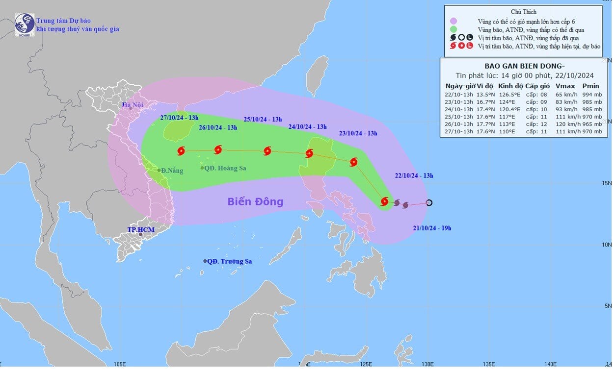
The movement of storm TRAMI. Photo: NCHMF.
Cold air will cause rain in the Central region
While storm TRAMI is on its way to the East Sea, currently (October 22), the cold air mass is continuing to move south.
According to the National Center for Hydro-Meteorological Forecasting, around the late afternoon and evening of October 22, this cold air mass will affect the mountainous areas of the North, then affect other areas in the Northeast, North Central, some areas in the Northwest and North Central. The Northeast wind will strengthen to level 3, coastal areas to level 4-5.
During this cold air mass, the weather in the Northern region, Thanh Hoa and Nghe An will be cool; from the night of October 23, the night and morning will be cold, especially in the mountainous areas of the North, the night and morning will be cold. The lowest temperature in the North is generally from 19-21 degrees, in the mountainous areas 17-19 degrees, in the high mountainous areas in some places below 16 degrees; in Thanh Hoa-Nghe An, the lowest temperature is generally from 20-23 degrees.
At sea: In the North East Sea, the Northeast wind is strong at level 6, sometimes at level 7, gusting to level 8-9; the sea is rough; the waves are 3.0-5.0m high; from the night of October 22, in the Gulf of Tonkin, the Northeast wind gradually increases to level 6, sometimes at level 7, gusting to level 8-9; the sea is rough; the waves are 2.0-3.5m high.
Due to the influence of the cold air, on the night of October 22, in the North and Thanh Hoa, there will be scattered showers and thunderstorms. From the evening of October 22 to the morning of October 23, in the area from Southern Nghe An to Quang Ngai, there will be moderate rain, heavy rain, locally very heavy rain and thunderstorms. Thunderstorms may include tornadoes, lightning, hail and strong gusts of wind.
 ") // // .removeAttr("style"); el.find(".first").show(); el.find("a.second").html(""); el.find("a.second").removeAttr("data-out"); $('.comment-account').html(`
 ") // // .removeAttr("style"); el.find(".first").show(); el.find("a.second").html(""); el.find("a.second").attr("data-out", "0"); $('.comment-account').html(` ") // .removeAttr("style"); //el.find("a.second").html(""); }); }; fnPopupBindAction(); //login Facebook var otherLogin = { init: function() { var me = this; //gapi.load('auth2', function () { // gapi.auth2.init({ // client_id: '678720187862-08lendtdt5h3nr4j2he534p15b13aieg.apps.googleusercontent.com', // scope: 'email profile', // fetch_basic_profile: true // }); //}); $("#cmt-account-social button[data-type]").on('click', function() { me[$(this).attr("data-type")](function(response) { $("#cmt-account-header .tabs .close, #cmt-account .tabs .close") .click(); }); }); try { fbClient.appId = '1304555827613749'; //'211029740744825'; fbClient.version = "v14.0"; fbClient.init(); setTimeout(FB.AppEvents.logPageView, 5000); } catch (e) { // ignore } }, loginFacebook: function(cb) { var me = this; function reloginFacebook(callback) { FB.api('/me', { fields: 'id, name, email' }, function(profile) { //console.debug(profile); if (typeof callback === "function") callback(profile); }); }; FB.login(function(response) { if (response.authResponse) { reloginFacebook(function(info) { console.log(info); info.social = "facebook"; info.accessToken = response.authResponse.accessToken; var user = { email: info.email, name: info.name, } let now = new Date(); lgSetCookie('my_dv',JSON.stringify(user), new Date(now.getTime() + (30 * 12 * 60000))); authLogin(user.name, true); }); } else { $("#cmt_alert").html( "You have denied permission to access your Facebook account"); } }, { scope: 'public_profile,email' }); }, loginGoogle: function(callback) { var me = this; function callSocialApi(data, cb) { data.social = "google"; var user = { email: data.email, name: data.name, } let now = new Date(); lgSetCookie('my_dv',JSON.stringify(user), new Date(now.getTime() + (30 * 12 * 60000))); authLogin(user.name, true); } // API call for Google login if (gapi.auth2.getAuthInstance().isSignedIn.get()) { //console.debug('[VCC] GAPI Process'); var profile = gapi.auth2.getAuthInstance().currentUser.get().getBasicProfile(); //var id_token = gapi.auth2.getAuthInstance().currentUser.get().getAuthResponse().id_token; var access_token = gapi.auth2.getAuthInstance().currentUser.get().getAuthResponse() .access_token; var params = { id: profile.getId(), name: profile.getName(), email: profile.getEmail(), accessToken: access_token } //console.log('params: ', params); callSocialApi(params, callback); } else { //console.debug('[VCC] GAPI Login'); gapi.auth2.getAuthInstance().signIn().then( function(success) { var profile = gapi.auth2.getAuthInstance().currentUser.get() .getBasicProfile(); //var id_token = gapi.auth2.getAuthInstance().currentUser.get().getAuthResponse().id_token; var access_token = gapi.auth2.getAuthInstance().currentUser.get() .getAuthResponse().access_token; var params = { id: profile.getId(), name: profile.getName(), email: profile.getEmail(), accessToken: access_token } //console.log('params: ', params); callSocialApi(params, callback); }, function(error) { $("#cmt_alert").html( "You have refused to grant Dan Viet Newspaper permission to access your Google account" ); } ); } } } otherLogin.init(); });
Source: https://danviet.vn/nong-2-ngay-nua-bao-trami-se-vao-bien-dong-thanh-bao-so-6-giat-toi-cap-15-20241022190129427.htm

![[Photo] Prime Minister Pham Minh Chinh receives Country Director of the World Bank Regional Office for Vietnam, Laos, Cambodia](https://vphoto.vietnam.vn/thumb/1200x675/vietnam/resource/IMAGE/2025/5/15/2c7898852fa74a67a7d39e601e287d48)
![[Photo] President Luong Cuong attends the National Ceremony to honor Uncle Ho's Good Children](https://vphoto.vietnam.vn/thumb/1200x675/vietnam/resource/IMAGE/2025/5/15/9defa1e6e3e743f59a79f667b0b6b3db)
![[Photo] In May, lotus flowers bloom in President Ho Chi Minh's hometown](https://vphoto.vietnam.vn/thumb/1200x675/vietnam/resource/IMAGE/2025/5/15/aed19c8fa5ef410ea0099d9ecf34d2ad)