
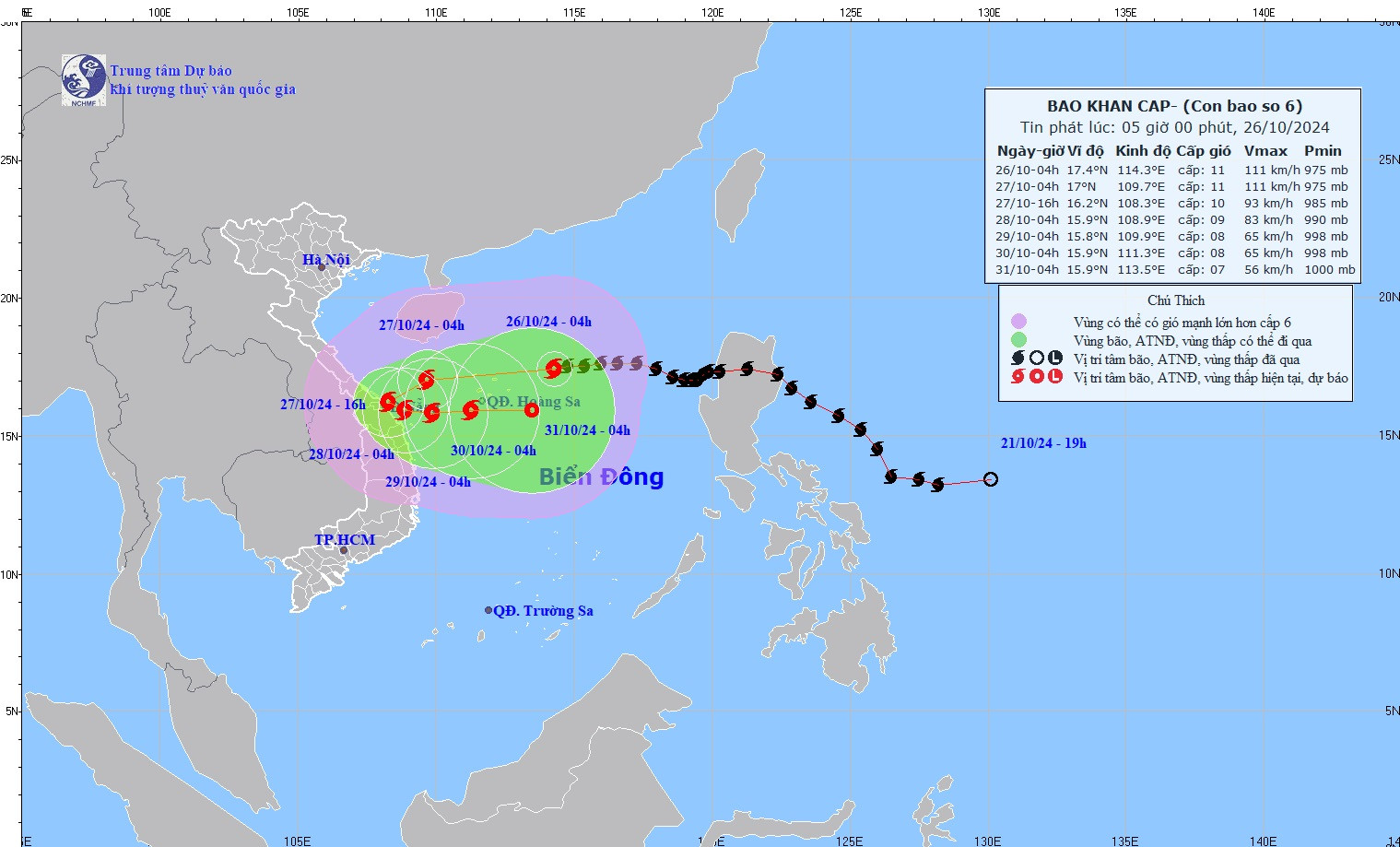
At 4:00 a.m. on October 26, storm No. 6 (Tra Mi) was at level 11, gusting to level 14, about 230km from Hoang Sa archipelago. In the Ly Son island area, there were strong winds of level 6, gusting to level 7-8. In the coming hours, storm No. 6 will continue to develop complicatedly.
According to the National Center for Hydro-Meteorological Forecasting, at 4:00 a.m. on October 26, the center of storm No. 6 (storm Tra Mi) was located at about 17.4 degrees North latitude; 114.3 degrees East longitude, about 230km from Hoang Sa archipelago.
The strongest wind near the storm center is level 11 (103-117km/h), gusting to level 14. The storm moves west at a speed of about 20km/h.
Due to the impact of storm Tra Mi, the North East Sea area has strong winds of level 6-8, near the storm center level 9-10, gusting to level 12. In the Ly Son island area, there are strong winds of level 6, gusting to level 7-8.
In the North East Sea area there are storms; the northern sea area of the Central East Sea area has showers and strong thunderstorms.
The meteorological agency forecasts the development of storm No. 6 in the next 24 - 72 hours as follows:
| Forecast time | Direction, speed | Location | Intensity | Danger zone | Disaster Risk Level (Affected Area) |
|---|---|---|---|---|---|
| 4h/27/10 | West Southwest, about 20km/h | 17.0N-109.7E; in the sea off the Central Central Coast, about 200km East Northeast of Quang Tri-Quang Nam | Level 11, jerk level 14 | Parallel 15.5N-19.5N; West of Longitude 117.0E | Level 3: North East Sea area (including Hoang Sa archipelago area), Central Central Coast sea area |
| 4h/28/10 | West Southwest then Southeast, about 10km/h | 15.9N-108.9E; in coastal waters of the Central Central provinces | Level 9, jerk level 11 | Latitude 14.5N-19.0N; West of longitude 112.0E | Level 3: West of the North East Sea area (including the area west of Hoang Sa archipelago), Central Central Coast sea area |
| 4h/29/10 | East, about 5km/h | 15.8N-109.9E; on the sea of the Central Central provinces | Level 8, level 10 jerk | Latitude 14.5N-18.0N; West of longitude 113.0E | Level 3: Southwest of the North East Sea area (including the area west of Hoang Sa archipelago), Central Central Coast sea area |
From the next 72 to 120 hours, the storm will move mainly to the East at about 10km per hour, and its intensity will continue to weaken.
Forecasting the impact of storm Tra Mi
Storms cause strong winds, big waves, and rising water.
At sea, in the North East Sea, strong winds level 8-9, near the storm center level 10-11 (89-117km/h), gusts level 14, waves 5-7m high, near the storm center 7-9m; rough seas.
From the night of October 26, the sea areas from Quang Binh to Quang Ngai (including Con Co Island, Cu Lao Cham, Ly Son) will have winds gradually increasing to level 6 - 7, then increasing to level 8 - 9, near the storm's eye level 10 - 11, gusting to level 14, waves 3 - 5m high, near the storm's eye 5 - 7m; the sea is very rough.
From the morning of October 27, coastal areas from Quang Tri to Quang Nam provinces are likely to experience storm surges of 0.4-0.6m high.
Ships operating in the above-mentioned dangerous areas (especially in the Hoang Sa island district), coastal areas from Quang Binh - Quang Ngai are all likely to be affected by storms, whirlwinds, strong winds, and big waves.
High risk of landslides of sea dikes and embankments along the coast of the provinces from Quang Tri to Quang Nam due to the impact of big waves and storm surges.
On land, from the morning of October 27, the coastal area from Quang Binh to Quang Ngai will have winds gradually increasing to level 6 - 7, near the storm center level 8 - 9, gusting to level 11.
Storm Tra Mi will cause heavy rain. From the evening and night of October 26 to October 28, in the Quang Tri - Quang Ngai area, there will be heavy to very heavy rain with total rainfall ranging from 300-500mm, locally over 700mm. Warning of the risk of local heavy rain (>100mm/3h).
Ha Tinh-Quang Binh, Binh Dinh and the Northern Central Highlands regions have heavy rain, locally very heavy rain with total rainfall ranging from 100-200mm, in some places over 300mm.
According to Mr. Hoang Phuc Lam - Deputy Director of the National Center for Hydro-Meteorological Forecasting, it is forecasted that on October 25-26, the storm will move steadily in the West and West Southwest direction, towards the Hoang Sa archipelago and continue to strengthen.
However, after passing through the Paracel Islands, the storm interacted with the cold air mass flowing down from the North, making its trajectory complex and unpredictable. There are two possible scenarios.
Scenario 1 : After interacting with cold air, the storm moves slowly in a West-Southwest direction and begins to weaken. At 1:00 p.m. on October 27, the storm center is in the western area of Hoang Sa archipelago, about 180km northeast of Quang Tri - Quang Ngai, with a strong intensity of level 10-11, gusting to level 14.
The storm then turned southwest, touched the shore in the Hue - Quang Nam area, then turned east-southeast, continued to turn east and back out to sea. After going out to sea, the storm remnants formed a tropical convergence zone in the central and southern East Sea. The probability of this scenario is about 60%.
The second scenario , after interacting with cold air from the North, the storm weakens, moves inland and gradually dissipates. This scenario has a probability of about 30%.
Regardless of the storm's scenario, the Central region, especially the provinces from Ha Tinh to Quang Ngai, will suffer a prolonged period of heavy rain.

Source: https://vietnamnet.vn/tin-bao-moi-nhat-26-10-bao-so-6-tra-mi-giat-cap-14-cach-hoang-sa-230km-2335677.html


![[Photo] Buddha's Birthday 2025: Honoring the message of love, wisdom, and tolerance](https://vphoto.vietnam.vn/thumb/1200x675/vietnam/resource/IMAGE/2025/5/12/8cd2a70beb264374b41fc5d36add6c3d)


![[Photo] General Secretary To Lam meets and expresses gratitude to Vietnam's Belarusian friends](https://vphoto.vietnam.vn/thumb/1200x675/vietnam/resource/IMAGE/2025/5/11/c515ee2054c54a87aa8a7cb520f2fa6e)
![[Photo] General Secretary To Lam arrives in Minsk, begins state visit to Belarus](https://vphoto.vietnam.vn/thumb/1200x675/vietnam/resource/IMAGE/2025/5/11/76602f587468437f8b5b7104495f444d)


Comment (0)