
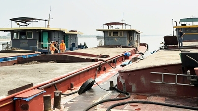
The Red River has dried up, exposing the foundation of Van Lang Bridge connecting Ba Vi District ( Hanoi ) and Viet Tri City (Phu Tho).
WATCH CLIP:
According to the National Center for Hydro-Meteorological Forecasting, the water level of the Red River in Phu Tho is at 11.03m and will change slowly in the short term.
Due to the low water level of the Red River, the foundation of Van Lang Bridge has been exposed. This is a bridge with a total investment of nearly 1,500 billion VND and was opened to traffic in 2018.
The starting point of the bridge (Hanoi side) connects with National Highway 32 in Phu Son commune, Ba Vi district. The end point on Phu Tho side intersects with National Highway 32C in Tho Son ward, Viet Tri city.
The total length of the bridge and approach roads is about 9.46km. Of which, the length of the river crossing bridge is about 1.55km.
Below are images of some of the Van Lang bridge's pier foundations clearly visible when the Red River water level is low:


Source: https://vietnamnet.vn/song-hong-can-tro-day-lo-mong-cau-nghin-ty-noi-ha-noi-phu-tho-2361882.html
![[Photo] More than 17,000 candidates participate in the 2025 SPT Competency Assessment Test of Hanoi National University of Education](https://vphoto.vietnam.vn/thumb/1200x675/vietnam/resource/IMAGE/2025/5/17/e538d9a1636c407cbb211b314e6303fd)

![[Photo] Readers line up to visit the photo exhibition and receive a special publication commemorating the 135th birthday of President Ho Chi Minh at Nhan Dan Newspaper](https://vphoto.vietnam.vn/thumb/1200x675/vietnam/resource/IMAGE/2025/5/17/85b3197fc6bd43e6a9ee4db15101005b)


![[Photo] Prime Minister Pham Minh Chinh chairs meeting on science and technology development](https://vphoto.vietnam.vn/thumb/1200x675/vietnam/resource/IMAGE/2025/5/17/ae80dd74c384439789b12013c738a045)


![[Photo] Nearly 3,000 students moved by stories about soldiers](https://vphoto.vietnam.vn/thumb/1200x675/vietnam/resource/IMAGE/2025/5/17/21da57c8241e42438b423eaa37215e0e)


Comment (0)