
On June 21, Mr. Nguyen Van Huong, Head of Weather Forecast Department, National Center for Hydro-Meteorological Forecasting, said that the North and Central East Sea areas are forming a low pressure trough with a Northwest - Southeast axis.
According to meteorological experts, around June 23-24, this low-pressure trough is likely to form, with a 65-75% probability of strengthening into a tropical depression.
"With the development of climate laws during this period, when the low pressure area strengthens into a tropical depression, there will be two directions of movement, one is the possibility of entering mainland China, the other is entering the Gulf of Tonkin and affecting mainland Vietnam," said Mr. Huong.
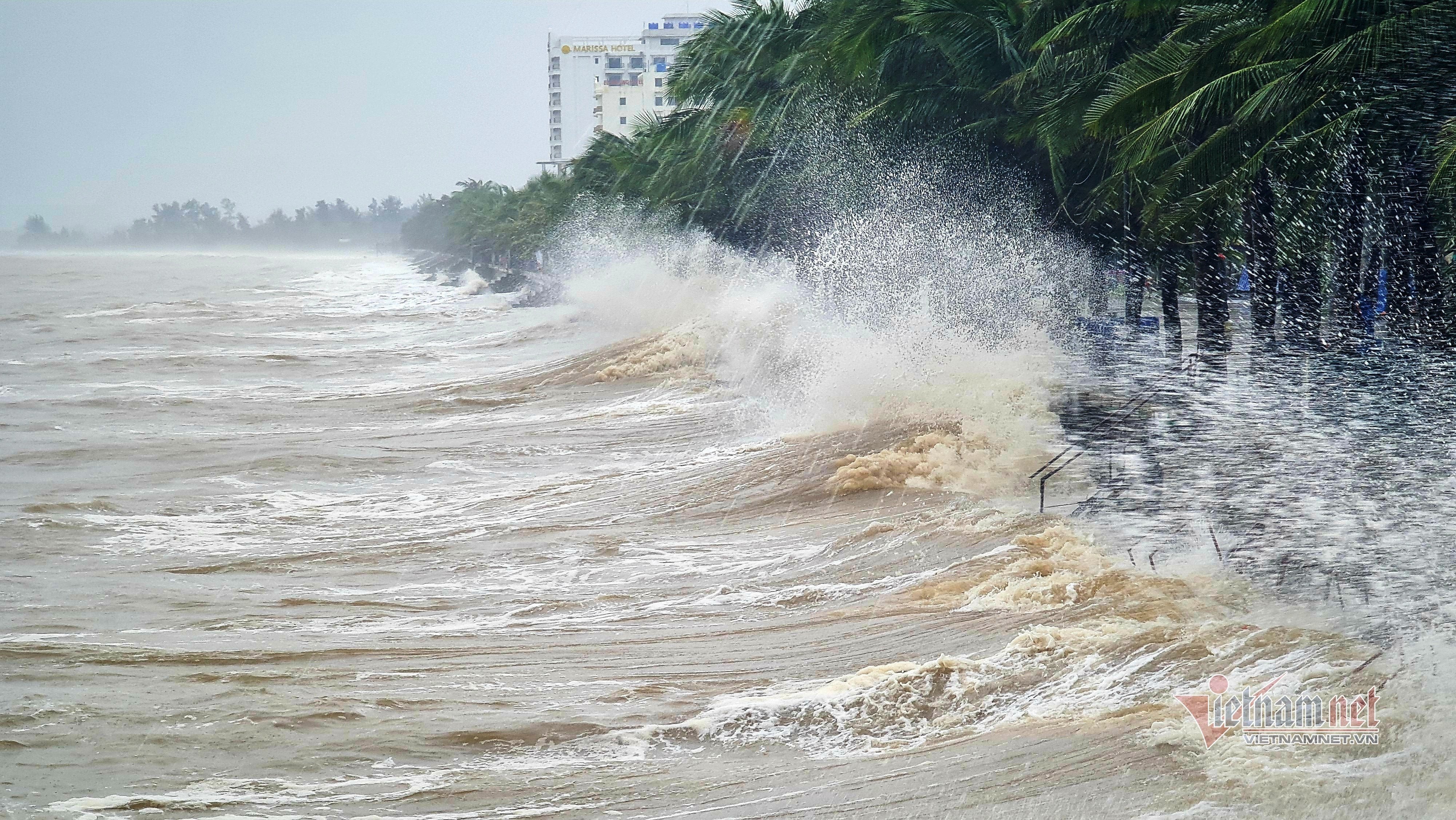
Mr. Huong commented that due to the impact of the low pressure area that is likely to strengthen into a tropical depression, the southern area of the East Sea, the sea area from Binh Thuan to Ca Mau is experiencing strong southwest winds and the trend is to continue to strengthen in the coming time, causing bad weather in the southern area of the East Sea, the Binh Thuan - Ca Mau area with waves 2-3m high, and heavy rain and thunderstorms.
In addition, the low pressure area strengthening into a tropical depression will cause bad weather in the North and Central East Sea in the coming time.
Regarding the heat wave in the North and Central regions, Mr. Huong said that the appearance of the Northwest - Southeast low pressure trough has caused changes in the weather in the Northern provinces.
Specifically, the Southeast wind has caused the low pressure area in the West to weaken. Therefore, in the coming time, the heat in the North and Central regions will tend to decrease.
Experts say that from June 22 onwards, the heat will gradually ease. From June 23, the heat in the North will end, and in the Central region it will ease significantly.
Accordingly, today, the midlands and the Northern Delta, Hoa Binh and from Da Nang to Quang Ngai will only have a few severe hot spots, with the highest temperature from 35-37 degrees, some places above 37 degrees; the lowest relative humidity is commonly 50-55%.
From Thanh Hoa to Thua Thien Hue, the hot weather continues to be extremely severe with the highest temperature from 36-39 degrees, some places over 39 degrees; the lowest relative humidity is 40-45%.
Tomorrow (June 22), the heat in the North will gradually decrease. From Thanh Hoa to Thua Thien Hue, the highest temperature will decrease to 35-37 degrees, some places will be over 37 degrees; the lowest relative humidity will be 50-55%. From June 23, the heat in the Central region will also decrease.
In addition, this evening and tonight, the weather in the North will have scattered showers and thunderstorms, locally heavy rain with rainfall from 15-30mm, some places over 70mm.
From the night of June 22-23, the Northwest region will have scattered showers and thunderstorms (concentrated in the evening and at night). From June 25-27, the North will have scattered showers and thunderstorms, locally heavy rain; from June 28-29, in the evening and at night, there will be scattered showers and thunderstorms.
Also today and tonight, the area from Quang Ngai to Binh Thuan will have showers and thunderstorms, locally heavy to very heavy rain with rainfall from 20-50mm, some places over 80mm.
From Thanh Hoa to Thua Thien Hue, after the heat wave has subsided, from the evening of June 23, there is a possibility of scattered showers and thunderstorms. From Da Nang to Binh Thuan, from the night of June 22-24, there will also be scattered showers and thunderstorms, with some areas having heavy to very heavy rain. Rain in these areas will mainly be concentrated in the late afternoon and evening.
For the Central Highlands and the South, on June 21-22, there will be moderate rain, heavy rain and thunderstorms, locally very heavy rain with common rainfall from 40-80mm, some places over 150mm; moderate rain, heavy rain mainly concentrated in the afternoon and at night. From the night of June 22-25, there will be showers and scattered thunderstorms, locally heavy rain. During thunderstorms, there is a possibility of tornadoes, lightning, hail and strong gusts of wind.
Possibility of 1-2 storms/tropical depressions in the next month
In a further forecast, the National Center for Hydro-Meteorological Forecasting said that from June 21 to July 20, 2024, the average temperature across the country will generally be 0.5-1 degree Celsius higher than the average of many years; in the South Central, Central Highlands and Southern regions, it will be about 1-1.5 degrees higher. At the same time, the total rainfall will be approximately the same as the average of many years in the same period.
Heat wave continues in the Northern and Central regions.
During the forecast period, there is a possibility of 1-2 storms/tropical depressions appearing in the East Sea.
In addition, during this period, the Northern, North Central, Central Highlands and Southern regions will have many days of showers and thunderstorms, including the possibility of some widespread moderate and heavy rain lasting about 2-4 days.
The meteorological agency noted that dangerous weather phenomena such as storms/tropical depressions and southwest monsoons are likely to cause strong winds and large waves, affecting activities in the East Sea. Strong thunderstorms accompanied by whirlwinds, lightning, hail and strong gusts of wind can greatly affect production and people's activities.
In the Central and South Central regions during this period, there is still a possibility of little rain and more heat, leading to drought, water shortages and a very high risk of fire and explosion.

Weather forecast for the next 10 days: Heat wave over 39 degrees then continuous thunderstorms
Weather forecast for the next 10 days (June 20-30), the North will have extremely hot weather for 2 more days, then thunderstorms will appear, the temperature will drop slightly and last for about 1 week. The Central Highlands and the South will have long-term rain.

![[Photo] General Secretary To Lam arrives in Minsk, begins state visit to Belarus](https://vphoto.vietnam.vn/thumb/1200x675/vietnam/resource/IMAGE/2025/5/11/76602f587468437f8b5b7104495f444d)
![[Photo] General Secretary To Lam meets and expresses gratitude to Vietnam's Belarusian friends](https://vphoto.vietnam.vn/thumb/1200x675/vietnam/resource/IMAGE/2025/5/11/c515ee2054c54a87aa8a7cb520f2fa6e)


![[Photo] General Secretary To Lam concludes visit to Russia, departs for Belarus](https://vphoto.vietnam.vn/thumb/1200x675/vietnam/resource/IMAGE/2025/5/11/0acf1081a95e4b1d9886c67fdafd95ed)


Comment (0)